![](/images/other/stat-length.png)
![Trail Walking Seborga - SEBORGA et le Monte NERO - Photo](https://media.geolcdn.com/t/1900/400/ext.pjpeg?maxdim=2&url=https%3A%2F%2Fservices.sitytrail.com%2FGeolivesWS%2FDownloadMedia.ashx%3FTrailID%3D472084%26Media%3Dfix__20150914140159.jpg)
SEBORGA et le Monte NERO
jeanclaude12
User
![Length](/images/other/stat-length.png)
Length
13.9 km
![Max alt](https://static1.geolcdn.com/siteimages/upload/files/1508320355ic_sort_altitude_max_24dp.png)
Max alt
647 m
![Uphill gradient](https://static1.geolcdn.com/siteimages/upload/files/1508320355ic_sort_den_pos_24dp.png)
Uphill gradient
494 m
![Km-Effort](/images/other/stat-length.png)
Km-Effort
21 km
![Min alt](https://static1.geolcdn.com/siteimages/upload/files/1508320355ic_sort_altitude_min_24dp.png)
Min alt
443 m
![Downhill gradient](https://static1.geolcdn.com/siteimages/upload/files/1508320355ic_sort_den_neg_24dp.png)
Downhill gradient
501 m
![Boucle](https://static1.geolcdn.com/siteimages/upload/files/16400158638029165_repeat_loop_refresh_sync_direction_icon.png)
Boucle
Yes
Creation date :
2015-09-15 00:00:00.0
Updated on :
2015-09-15 00:00:00.0
![Walking](https://static1.geolcdn.com/sitytour/trail-icons/101.png)
5h00
Difficulty : Easy
![Scan this QR Code to open this trail in the SityTrail application](https://capi.geolives.com/qq0zvz2zws4bq2lad0pu/sitytour/trails/472084/qr.png?size=200)
FREE GPS app for hiking
About
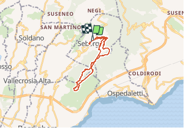
Trail Walking of 13.9 km to be discovered at Liguria, Imperia, Seborga. This trail is proposed by jeanclaude12.
Description
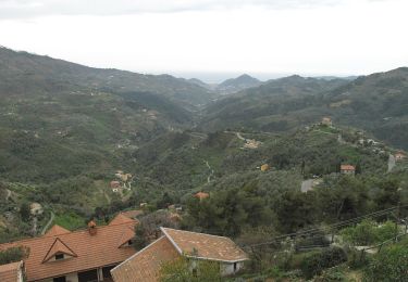
Très agréable randonnée, aux senteurs méditerranéennes, avec de superbes vues panoramiques au-dessus de Seborga dans la Valle del Sasso et en surplomb de San Remo, Ospedaletti et Bordighera.
Positioning
Country:
Italy
Region :
Liguria
Department/Province :
Imperia
Municipality :
Seborga
Location:
Unknown
Start:(Dec)
Start:(UTM)
395083 ; 4853478 (32T) N.
Comments
Trails nearby
![Trail Walking Sanremo - Monte Caggio 25.12.24 - Photo](https://media.geolcdn.com/t/375/260/9663de2c-8e96-4cad-b7b0-6ba43dd5874a.jpg&format=jpg&maxdim=2)
![Walking Walking](https://static1.geolcdn.com/sitytour/trail-icons/101.png)
Monte Caggio 25.12.24
Walking
Easy
Sanremo,
Liguria,
Imperia,
Italy
![](/images/other/stat-length.png)
3.7 km | 6.7 km-effort
1h 25min
![](https://static1.geolcdn.com/siteimages/upload/files/16400158638029165_repeat_loop_refresh_sync_direction_icon.png)
Yes
![Trail On foot Sanremo - Sentiero Balcone Mediterraneo T3 - Photo](https://media.geolcdn.com/t/375/260/d586e1d5-8531-4dde-8893-d425a9597deb.jpeg&format=jpg&maxdim=2)
![On foot On foot](https://static1.geolcdn.com/sitytour/trail-icons/100.png)
Sentiero Balcone Mediterraneo T3
On foot
Easy
Sanremo,
Liguria,
Imperia,
Italy
![](/images/other/stat-length.png)
5.4 km | 7.7 km-effort
1h 44min
![](https://static1.geolcdn.com/siteimages/upload/files/16400158638029165_repeat_loop_refresh_sync_direction_icon.png)
No
![Trail Walking Bordighera - bordighera - Photo](https://media.geolcdn.com/t/375/260/30c0d06e-4d8b-4fee-8056-7d50166bc4d5.jpg&format=jpg&maxdim=2)
![Walking Walking](https://static1.geolcdn.com/sitytour/trail-icons/101.png)
bordighera
Walking
Difficult
Bordighera,
Liguria,
Imperia,
Italy
![](/images/other/stat-length.png)
10.5 km | 19 km-effort
4h 58min
![](https://static1.geolcdn.com/siteimages/upload/files/16400158638029165_repeat_loop_refresh_sync_direction_icon.png)
Yes
![Trail Walking Perinaldo - apricale - Photo](https://media.geolcdn.com/t/375/260/38344c15-0851-4a86-9b60-9db057dcd64b.jpg&format=jpg&maxdim=2)
![Walking Walking](https://static1.geolcdn.com/sitytour/trail-icons/101.png)
![Trail Walking Perinaldo - Perinaldo Monte Caggio - Photo](https://media.geolcdn.com/t/375/260/ext.jpg?maxdim=2&url=https%3A%2F%2Fstatic1.geolcdn.com%2Fsiteimages%2Fupload%2Ffiles%2F1553511878bg_sport_marche.png)
![Walking Walking](https://static1.geolcdn.com/sitytour/trail-icons/101.png)
Perinaldo Monte Caggio
Walking
Easy
Perinaldo,
Liguria,
Imperia,
Italy
![](/images/other/stat-length.png)
10.6 km | 18.1 km-effort
3h 39min
![](https://static1.geolcdn.com/siteimages/upload/files/16400158638029165_repeat_loop_refresh_sync_direction_icon.png)
Yes
![Trail Walking Seborga - De Seborga à la chapelle St Bartolomeo - Photo](https://media.geolcdn.com/t/375/260/ext.jpg?maxdim=2&url=https%3A%2F%2Fstatic1.geolcdn.com%2Fsiteimages%2Fupload%2Ffiles%2F1553511878bg_sport_marche.png)
![Walking Walking](https://static1.geolcdn.com/sitytour/trail-icons/101.png)
De Seborga à la chapelle St Bartolomeo
Walking
Difficult
Seborga,
Liguria,
Imperia,
Italy
![](/images/other/stat-length.png)
11.2 km | 21 km-effort
5h 15min
![](https://static1.geolcdn.com/siteimages/upload/files/16400158638029165_repeat_loop_refresh_sync_direction_icon.png)
Yes