![](/images/other/stat-length.png)
![Trail Walking Saint-Géry-Vers - QUERCY (Causse) - Photo](https://media.geolcdn.com/t/1900/400/ext.pjpeg?maxdim=2&url=https%3A%2F%2Fservices.sitytrail.com%2FGeolivesWS%2FDownloadMedia.ashx%3FTrailID%3D472076%26Media%3Dfix__20150915174553.jpg)
QUERCY (Causse)
GerardBouche
User
![Length](/images/other/stat-length.png)
Length
6.2 km
![Max alt](https://static1.geolcdn.com/siteimages/upload/files/1508320355ic_sort_altitude_max_24dp.png)
Max alt
296 m
![Uphill gradient](https://static1.geolcdn.com/siteimages/upload/files/1508320355ic_sort_den_pos_24dp.png)
Uphill gradient
174 m
![Km-Effort](/images/other/stat-length.png)
Km-Effort
8.5 km
![Min alt](https://static1.geolcdn.com/siteimages/upload/files/1508320355ic_sort_altitude_min_24dp.png)
Min alt
142 m
![Downhill gradient](https://static1.geolcdn.com/siteimages/upload/files/1508320355ic_sort_den_neg_24dp.png)
Downhill gradient
171 m
![Boucle](https://static1.geolcdn.com/siteimages/upload/files/16400158638029165_repeat_loop_refresh_sync_direction_icon.png)
Boucle
Yes
Creation date :
2017-06-28 00:00:00.0
Updated on :
2017-06-28 00:00:00.0
![Walking](https://static1.geolcdn.com/sitytour/trail-icons/101.png)
1h48
Difficulty : Easy
![Scan this QR Code to open this trail in the SityTrail application](https://capi.geolives.com/qq0zvz2zws4bq2lad0pu/sitytour/trails/472076/qr.png?size=200)
FREE GPS app for hiking
About
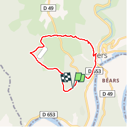
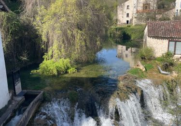
Trail Walking of 6.2 km to be discovered at Occitania, Lot, Saint-Géry-Vers. This trail is proposed by GerardBouche.
Description
Au départ du parking visiteurs "Mas de Saboth" belle balade avec pt de vue sur le Lot et petits sentiers ombragés par le chêne pubescent.
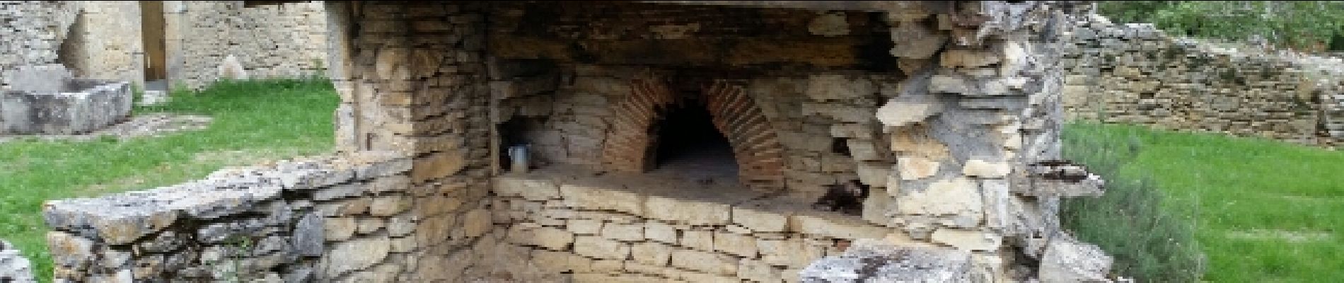
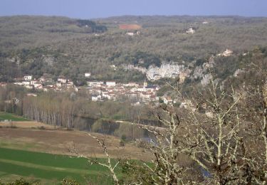
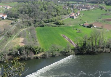
Positioning
Country:
France
Region :
Occitania
Department/Province :
Lot
Municipality :
Saint-Géry-Vers
Location:
Vers
Start:(Dec)
Start:(UTM)
384156 ; 4925927 (31T) N.
Comments
Trails nearby
![Trail Walking Saint-Géry-Vers - Vers, St Gery Vallée du Lot - Photo](https://media.geolcdn.com/t/375/260/ext.jpg?maxdim=2&url=https%3A%2F%2Fservices.sitytrail.com%2FGeolivesWS%2FDownloadMedia.ashx%3FTrailID%3D103241%26Media%3D5146_6.jpg)
![Walking Walking](https://static1.geolcdn.com/sitytour/trail-icons/101.png)
Vers, St Gery Vallée du Lot
Walking
Difficult
(3)
Saint-Géry-Vers,
Occitania,
Lot,
France
![](/images/other/stat-length.png)
14.1 km | 19.8 km-effort
4h 0min
![](https://static1.geolcdn.com/siteimages/upload/files/16400158638029165_repeat_loop_refresh_sync_direction_icon.png)
Yes
![Walking Walking](https://static1.geolcdn.com/sitytour/trail-icons/101.png)
Causse de Vers-7539719
Walking
Difficult
(1)
Saint-Géry-Vers,
Occitania,
Lot,
France
![](/images/other/stat-length.png)
11.6 km | 15.9 km-effort
3h 36min
![](https://static1.geolcdn.com/siteimages/upload/files/16400158638029165_repeat_loop_refresh_sync_direction_icon.png)
Yes
![Walking Walking](https://static1.geolcdn.com/sitytour/trail-icons/101.png)
randogps46-388
Walking
Difficult
(1)
Aujols,
Occitania,
Lot,
France
![](/images/other/stat-length.png)
11.9 km | 16.8 km-effort
3h 49min
![](https://static1.geolcdn.com/siteimages/upload/files/16400158638029165_repeat_loop_refresh_sync_direction_icon.png)
Yes
![Trail Walking Arcambal - Étape 5 Les Mazuts Cahen - Photo](https://media.geolcdn.com/t/375/260/2b1b58ea-d9da-4d3c-9ded-fdbc44ee415e.jpg&format=jpg&maxdim=2)
![Walking Walking](https://static1.geolcdn.com/sitytour/trail-icons/101.png)
Étape 5 Les Mazuts Cahen
Walking
Medium
Arcambal,
Occitania,
Lot,
France
![](/images/other/stat-length.png)
16.9 km | 21 km-effort
4h 40min
![](https://static1.geolcdn.com/siteimages/upload/files/16400158638029165_repeat_loop_refresh_sync_direction_icon.png)
No
![Trail Mountain bike Lamagdelaine - lamagdelaine, vers - Photo](https://media.geolcdn.com/t/375/260/283c2e24-a254-41e5-9434-72402b6820e6.jpg&format=jpg&maxdim=2)
![Mountain bike Mountain bike](https://static1.geolcdn.com/sitytour/trail-icons/202.png)
lamagdelaine, vers
Mountain bike
Very difficult
Lamagdelaine,
Occitania,
Lot,
France
![](/images/other/stat-length.png)
33 km | 41 km-effort
2h 19min
![](https://static1.geolcdn.com/siteimages/upload/files/16400158638029165_repeat_loop_refresh_sync_direction_icon.png)
Yes
![Trail Walking Saint-Géry-Vers - Boucle Vers - Merlan gr46 - Photo](https://media.geolcdn.com/t/375/260/2b826dd5-3670-4ee5-a059-34afa2c2d67d.jpg&format=jpg&maxdim=2)
![Walking Walking](https://static1.geolcdn.com/sitytour/trail-icons/101.png)
Boucle Vers - Merlan gr46
Walking
Easy
Saint-Géry-Vers,
Occitania,
Lot,
France
![](/images/other/stat-length.png)
14.7 km | 19.3 km-effort
4h 21min
![](https://static1.geolcdn.com/siteimages/upload/files/16400158638029165_repeat_loop_refresh_sync_direction_icon.png)
Yes
![Trail Walking Arcambal - Galessie les Mazuts Barouillet - Photo](https://media.geolcdn.com/t/375/260/16327faa-cf00-4004-ade5-741b674ecd90.jpg&format=jpg&maxdim=2)
![Walking Walking](https://static1.geolcdn.com/sitytour/trail-icons/101.png)
Galessie les Mazuts Barouillet
Walking
Very easy
Arcambal,
Occitania,
Lot,
France
![](/images/other/stat-length.png)
10.7 km | 13.9 km-effort
2h 30min
![](https://static1.geolcdn.com/siteimages/upload/files/16400158638029165_repeat_loop_refresh_sync_direction_icon.png)
Yes
![Trail Walking Saint-Géry-Vers - Vers merlan pech picou - Photo](https://media.geolcdn.com/t/375/260/012b6a5e-2859-438e-93b8-84dfecc2d09a.jpg&format=jpg&maxdim=2)
![Walking Walking](https://static1.geolcdn.com/sitytour/trail-icons/101.png)
Vers merlan pech picou
Walking
Very easy
Saint-Géry-Vers,
Occitania,
Lot,
France
![](/images/other/stat-length.png)
10.2 km | 13.5 km-effort
2h 13min
![](https://static1.geolcdn.com/siteimages/upload/files/16400158638029165_repeat_loop_refresh_sync_direction_icon.png)
No
![Trail Electric bike Saint-Géry-Vers - St gery St cirq Cabreret - Photo](https://media.geolcdn.com/t/375/260/d519f58f-2190-4a19-bfda-7ad5dc0cd01a.jpg&format=jpg&maxdim=2)
![Electric bike Electric bike](https://static1.geolcdn.com/sitytour/trail-icons/205.png)
St gery St cirq Cabreret
Electric bike
Very easy
Saint-Géry-Vers,
Occitania,
Lot,
France
![](/images/other/stat-length.png)
39 km | 51 km-effort
3h 24min
![](https://static1.geolcdn.com/siteimages/upload/files/16400158638029165_repeat_loop_refresh_sync_direction_icon.png)
Yes
Fait le 11/11 avec Bene joli sentier