![](/images/other/stat-length.png)
![Trail Walking Villaz - YHH115 Le Parmelan - Photo](https://media.geolcdn.com/t/1900/400/ext.pjpeg?maxdim=2&url=https%3A%2F%2Fstatic1.geolcdn.com%2Fsiteimages%2Fupload%2Ffiles%2F1553511878bg_sport_marche.png)
YHH115 Le Parmelan
yveshumbert
User
![Length](/images/other/stat-length.png)
Length
9.1 km
![Max alt](https://static1.geolcdn.com/siteimages/upload/files/1508320355ic_sort_altitude_max_24dp.png)
Max alt
1826 m
![Uphill gradient](https://static1.geolcdn.com/siteimages/upload/files/1508320355ic_sort_den_pos_24dp.png)
Uphill gradient
732 m
![Km-Effort](/images/other/stat-length.png)
Km-Effort
18.9 km
![Min alt](https://static1.geolcdn.com/siteimages/upload/files/1508320355ic_sort_altitude_min_24dp.png)
Min alt
1171 m
![Downhill gradient](https://static1.geolcdn.com/siteimages/upload/files/1508320355ic_sort_den_neg_24dp.png)
Downhill gradient
734 m
![Boucle](https://static1.geolcdn.com/siteimages/upload/files/16400158638029165_repeat_loop_refresh_sync_direction_icon.png)
Boucle
Yes
Creation date :
2015-09-11 00:00:00.0
Updated on :
2015-09-11 00:00:00.0
![Walking](https://static1.geolcdn.com/sitytour/trail-icons/101.png)
4h09
Difficulty : Difficult
![Scan this QR Code to open this trail in the SityTrail application](https://capi.geolives.com/qq0zvz2zws4bq2lad0pu/sitytour/trails/470802/qr.png?size=200)
FREE GPS app for hiking
About
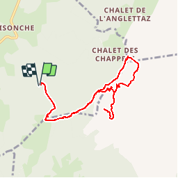
Trail Walking of 9.1 km to be discovered at Auvergne-Rhône-Alpes, Upper Savoy, Villaz. This trail is proposed by yveshumbert.
Description
Rando d' une journée en boucle au départ du parking du Parmelan.
Pour la montée prennez le chemin qui monte directement au grand Montoire et à la descente celui qui passe par le petit Montoire Du sommet du Parmelan vous aurez une très jolie vue sur Annecy
Positioning
Country:
France
Region :
Auvergne-Rhône-Alpes
Department/Province :
Upper Savoy
Municipality :
Villaz
Location:
Unknown
Start:(Dec)
Start:(UTM)
284719 ; 5092464 (32T) N.
Comments
Trails nearby
![Trail Walking Fillière - LE PARMELAN: ANGLETTAZ - GRANDE GLACIERE - GROTTE DE L'ENFER - LAPIAZ - REFUGE... RETOUR PAR GRAND & PETIT MONTOIR - Photo](https://media.geolcdn.com/t/375/260/722005e2-5797-472c-b09d-da3e50a0e57d.jpg&format=jpg&maxdim=2)
![Walking Walking](https://static1.geolcdn.com/sitytour/trail-icons/101.png)
LE PARMELAN: ANGLETTAZ - GRANDE GLACIERE - GROTTE DE L'ENFER - LAPIAZ - REFUG...
Walking
Difficult
(2)
Fillière,
Auvergne-Rhône-Alpes,
Upper Savoy,
France
![](/images/other/stat-length.png)
9 km | 15.6 km-effort
4h 30min
![](https://static1.geolcdn.com/siteimages/upload/files/16400158638029165_repeat_loop_refresh_sync_direction_icon.png)
Yes
![Trail Walking Fillière - refuge Patmelan via anglettaz . gd glacière . fontaine du tour . grotte de l enfer / retour via gd montoir et pt montoir - Photo](https://media.geolcdn.com/t/375/260/d9aff979-a700-421f-a6a0-6747275eea2c.jpg&format=jpg&maxdim=2)
![Walking Walking](https://static1.geolcdn.com/sitytour/trail-icons/101.png)
refuge Patmelan via anglettaz . gd glacière . fontaine du tour . grotte de l ...
Walking
Medium
Fillière,
Auvergne-Rhône-Alpes,
Upper Savoy,
France
![](/images/other/stat-length.png)
10.2 km | 16.1 km-effort
6h 1min
![](https://static1.geolcdn.com/siteimages/upload/files/16400158638029165_repeat_loop_refresh_sync_direction_icon.png)
Yes
![Trail Walking Fillière - tour parmelan - Photo](https://media.geolcdn.com/t/375/260/ext.jpg?maxdim=2&url=https%3A%2F%2Fstatic1.geolcdn.com%2Fsiteimages%2Fupload%2Ffiles%2F1553511878bg_sport_marche.png)
![Walking Walking](https://static1.geolcdn.com/sitytour/trail-icons/101.png)
tour parmelan
Walking
Easy
(2)
Fillière,
Auvergne-Rhône-Alpes,
Upper Savoy,
France
![](/images/other/stat-length.png)
12.9 km | 22 km-effort
4h 0min
![](https://static1.geolcdn.com/siteimages/upload/files/16400158638029165_repeat_loop_refresh_sync_direction_icon.png)
Yes
![Trail Walking Fillière - chalet de l'angletaz pour Umi - Photo](https://media.geolcdn.com/t/375/260/31a59abd-fd5f-44b3-890d-ba2d03dc72c1.jpg&format=jpg&maxdim=2)
![Walking Walking](https://static1.geolcdn.com/sitytour/trail-icons/101.png)
chalet de l'angletaz pour Umi
Walking
Easy
Fillière,
Auvergne-Rhône-Alpes,
Upper Savoy,
France
![](/images/other/stat-length.png)
3.8 km | 5.7 km-effort
1h 11min
![](https://static1.geolcdn.com/siteimages/upload/files/16400158638029165_repeat_loop_refresh_sync_direction_icon.png)
Yes
![Trail Walking Fillière - LE PARMELAN: ANGLETTAZ - GRANDE GLACIERE -](https://media.geolcdn.com/t/375/260/1a67916c-32da-4c49-ba0d-07b010a4e013.jpg&format=jpg&maxdim=2)
![Walking Walking](https://static1.geolcdn.com/sitytour/trail-icons/101.png)
LE PARMELAN: ANGLETTAZ - GRANDE GLACIERE - "LES LAPIAZ" - REFUGE DU PARMELAN ...
Walking
Medium
(1)
Fillière,
Auvergne-Rhône-Alpes,
Upper Savoy,
France
![](/images/other/stat-length.png)
9.4 km | 14.5 km-effort
4h 35min
![](https://static1.geolcdn.com/siteimages/upload/files/16400158638029165_repeat_loop_refresh_sync_direction_icon.png)
Yes
![Trail On foot Dingy-Saint-Clair - PR Boucle du Parmelan - Photo](https://media.geolcdn.com/t/375/260/6f92a529-84d8-4dac-bcdf-47427f9f0956.jpeg&format=jpg&maxdim=2)
![On foot On foot](https://static1.geolcdn.com/sitytour/trail-icons/100.png)
PR Boucle du Parmelan
On foot
Medium
Dingy-Saint-Clair,
Auvergne-Rhône-Alpes,
Upper Savoy,
France
![](/images/other/stat-length.png)
11.3 km | 25 km-effort
5h 38min
![](https://static1.geolcdn.com/siteimages/upload/files/16400158638029165_repeat_loop_refresh_sync_direction_icon.png)
No
![Trail Walking Annecy - Belvédère mont Baron - Photo](https://media.geolcdn.com/t/375/260/9f969196-bc81-4eef-b145-80c017b0d1a2.jpg&format=jpg&maxdim=2)
![Walking Walking](https://static1.geolcdn.com/sitytour/trail-icons/101.png)
Belvédère mont Baron
Walking
Medium
Annecy,
Auvergne-Rhône-Alpes,
Upper Savoy,
France
![](/images/other/stat-length.png)
6.3 km | 11.6 km-effort
2h 17min
![](https://static1.geolcdn.com/siteimages/upload/files/16400158638029165_repeat_loop_refresh_sync_direction_icon.png)
Yes
![Trail Walking Fillière - Tete du Parmelan - Photo](https://media.geolcdn.com/t/375/260/e502a722-32d6-4592-b868-3c83d0cfe463.jpg&format=jpg&maxdim=2)
![Walking Walking](https://static1.geolcdn.com/sitytour/trail-icons/101.png)
Tete du Parmelan
Walking
Difficult
Fillière,
Auvergne-Rhône-Alpes,
Upper Savoy,
France
![](/images/other/stat-length.png)
14.9 km | 26 km-effort
7h 15min
![](https://static1.geolcdn.com/siteimages/upload/files/16400158638029165_repeat_loop_refresh_sync_direction_icon.png)
Yes
![Trail Walking Nâves-Parmelan - Parmelan (depuis Nâves) - Photo](https://media.geolcdn.com/t/375/260/ext.jpg?maxdim=2&url=https%3A%2F%2Fservices.sitytrail.com%2FGeolivesWS%2FDownloadMedia.ashx%3FTrailID%3D149712%26Media%3D20120826135829.jpeg)
![Walking Walking](https://static1.geolcdn.com/sitytour/trail-icons/101.png)
Parmelan (depuis Nâves)
Walking
Medium
Nâves-Parmelan,
Auvergne-Rhône-Alpes,
Upper Savoy,
France
![](/images/other/stat-length.png)
6.3 km | 17.3 km-effort
4h 5min
![](https://static1.geolcdn.com/siteimages/upload/files/16400158638029165_repeat_loop_refresh_sync_direction_icon.png)
No