![](/images/other/stat-length.png)
![Trail Walking Fontenu - Chalain - Photo](https://media.geolcdn.com/t/1900/400/ext.pjpeg?maxdim=2&url=https%3A%2F%2Fstatic1.geolcdn.com%2Fsiteimages%2Fupload%2Ffiles%2F1553511878bg_sport_marche.png)
Chalain
dominiq
User
![Length](/images/other/stat-length.png)
Length
11.2 km
![Max alt](https://static1.geolcdn.com/siteimages/upload/files/1508320355ic_sort_altitude_max_24dp.png)
Max alt
612 m
![Uphill gradient](https://static1.geolcdn.com/siteimages/upload/files/1508320355ic_sort_den_pos_24dp.png)
Uphill gradient
341 m
![Km-Effort](/images/other/stat-length.png)
Km-Effort
15.7 km
![Min alt](https://static1.geolcdn.com/siteimages/upload/files/1508320355ic_sort_altitude_min_24dp.png)
Min alt
486 m
![Downhill gradient](https://static1.geolcdn.com/siteimages/upload/files/1508320355ic_sort_den_neg_24dp.png)
Downhill gradient
341 m
![Boucle](https://static1.geolcdn.com/siteimages/upload/files/16400158638029165_repeat_loop_refresh_sync_direction_icon.png)
Boucle
Yes
Creation date :
2015-09-11 00:00:00.0
Updated on :
2015-09-11 00:00:00.0
![Walking](https://static1.geolcdn.com/sitytour/trail-icons/101.png)
3h27
Difficulty : Easy
![Scan this QR Code to open this trail in the SityTrail application](https://capi.geolives.com/qq0zvz2zws4bq2lad0pu/sitytour/trails/470741/qr.png?size=200)
FREE GPS app for hiking
About
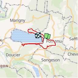
Trail Walking of 11.2 km to be discovered at Bourgogne-Franche-Comté, Jura, Fontenu. This trail is proposed by dominiq.
Description
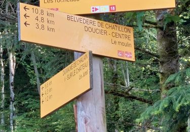
Le départ n'a pas été correctement enregistré mais il faut suivre le sentier qui monte en pente douce au dessus du lac puis suivre la route jusqu'au virage et prendre le sentier à gauche.
Positioning
Country:
France
Region :
Bourgogne-Franche-Comté
Department/Province :
Jura
Municipality :
Fontenu
Location:
Unknown
Start:(Dec)
Start:(UTM)
715080 ; 5171841 (31T) N.
Comments
Trails nearby
![Trail Walking Menétrux-en-Joux - Les cascades du Hérisson : Boucle du randonneur - Photo](https://media.geolcdn.com/t/375/260/ext.jpg?maxdim=2&url=https%3A%2F%2Fservices.sitytrail.com%2FGeolivesWS%2FDownloadMedia.ashx%3FTrailID%3D792637%26Media%3Dfix__20170718143932.jpg)
![Walking Walking](https://static1.geolcdn.com/sitytour/trail-icons/101.png)
Les cascades du Hérisson : Boucle du randonneur
Walking
Medium
(3)
Menétrux-en-Joux,
Bourgogne-Franche-Comté,
Jura,
France
![](/images/other/stat-length.png)
14.5 km | 20 km-effort
5h 10min
![](https://static1.geolcdn.com/siteimages/upload/files/16400158638029165_repeat_loop_refresh_sync_direction_icon.png)
Yes
![Trail Walking Menétrux-en-Joux - Le Hérisson et ses cascades - Photo](https://media.geolcdn.com/t/375/260/ext.jpg?maxdim=2&url=https%3A%2F%2Fservices.sitytrail.com%2FGeolivesWS%2FDownloadMedia.ashx%3FTrailID%3D109457%26Media%3D3924_2.jpg)
![Walking Walking](https://static1.geolcdn.com/sitytour/trail-icons/101.png)
Le Hérisson et ses cascades
Walking
Medium
(7)
Menétrux-en-Joux,
Bourgogne-Franche-Comté,
Jura,
France
![](/images/other/stat-length.png)
11.9 km | 17.6 km-effort
4h 0min
![](https://static1.geolcdn.com/siteimages/upload/files/16400158638029165_repeat_loop_refresh_sync_direction_icon.png)
Yes
![Trail Mountain bike Doucier - La Dame Blanche - Doucier - Photo](https://media.geolcdn.com/t/375/260/ext.jpg?maxdim=2&url=https%3A%2F%2Fservices.sitytrail.com%2FGeolivesWS%2FDownloadMedia.ashx%3FTrailID%3D104084%26Media%3D7109_1.jpg)
![Mountain bike Mountain bike](https://static1.geolcdn.com/sitytour/trail-icons/202.png)
La Dame Blanche - Doucier
Mountain bike
Difficult
(1)
Doucier,
Bourgogne-Franche-Comté,
Jura,
France
![](/images/other/stat-length.png)
33 km | 42 km-effort
2h 30min
![](https://static1.geolcdn.com/siteimages/upload/files/16400158638029165_repeat_loop_refresh_sync_direction_icon.png)
Yes
![Trail Walking Menétrux-en-Joux - Menetrux. Les Cascades du hérisson. - Photo](https://media.geolcdn.com/t/375/260/8e5e2f86-bd6e-477f-a743-cdfd861bfcc6.jpg&format=jpg&maxdim=2)
![Walking Walking](https://static1.geolcdn.com/sitytour/trail-icons/101.png)
Menetrux. Les Cascades du hérisson.
Walking
Medium
Menétrux-en-Joux,
Bourgogne-Franche-Comté,
Jura,
France
![](/images/other/stat-length.png)
13.9 km | 20 km-effort
3h 59min
![](https://static1.geolcdn.com/siteimages/upload/files/16400158638029165_repeat_loop_refresh_sync_direction_icon.png)
Yes
![Trail Walking Menétrux-en-Joux - Ménétrux-en-Joux - cascades Evantail et Hérisson - Saut de la Forge - La Fromagerie - Photo](https://media.geolcdn.com/t/375/260/d48ed8df-2feb-4b91-8f37-fd07908921c0.jpg&format=jpg&maxdim=2)
![Walking Walking](https://static1.geolcdn.com/sitytour/trail-icons/101.png)
Ménétrux-en-Joux - cascades Evantail et Hérisson - Saut de la Forge - La From...
Walking
Very difficult
Menétrux-en-Joux,
Bourgogne-Franche-Comté,
Jura,
France
![](/images/other/stat-length.png)
13.6 km | 19.7 km-effort
4h 28min
![](https://static1.geolcdn.com/siteimages/upload/files/16400158638029165_repeat_loop_refresh_sync_direction_icon.png)
Yes
![Trail Walking Doucier - Balisage Lac de Chambly - Photo](https://media.geolcdn.com/t/375/260/a66299b1-acba-4c28-b135-ec0a9e2beef8.jpg&format=jpg&maxdim=2)
![Walking Walking](https://static1.geolcdn.com/sitytour/trail-icons/101.png)
Balisage Lac de Chambly
Walking
Difficult
(1)
Doucier,
Bourgogne-Franche-Comté,
Jura,
France
![](/images/other/stat-length.png)
11.4 km | 14.6 km-effort
3h 19min
![](https://static1.geolcdn.com/siteimages/upload/files/16400158638029165_repeat_loop_refresh_sync_direction_icon.png)
Yes
![Trail Walking Fontenu - Tour du lac de Chalain - Photo](https://media.geolcdn.com/t/375/260/1c5595f4-5d36-4f85-b728-7ff9b046c0c9.jpg&format=jpg&maxdim=2)
![Walking Walking](https://static1.geolcdn.com/sitytour/trail-icons/101.png)
Tour du lac de Chalain
Walking
Medium
Fontenu,
Bourgogne-Franche-Comté,
Jura,
France
![](/images/other/stat-length.png)
12.7 km | 16.3 km-effort
3h 56min
![](https://static1.geolcdn.com/siteimages/upload/files/16400158638029165_repeat_loop_refresh_sync_direction_icon.png)
Yes
![Trail Walking Menétrux-en-Joux - CASCADES DU HERISSON DEPUIS MENETRUX-EN-JOUX - Photo](https://media.geolcdn.com/t/375/260/e70f75bd-2d3f-4c85-950b-39b567cdc95a.jpg&format=jpg&maxdim=2)
![Walking Walking](https://static1.geolcdn.com/sitytour/trail-icons/101.png)
CASCADES DU HERISSON DEPUIS MENETRUX-EN-JOUX
Walking
Very difficult
Menétrux-en-Joux,
Bourgogne-Franche-Comté,
Jura,
France
![](/images/other/stat-length.png)
15 km | 21 km-effort
4h 0min
![](https://static1.geolcdn.com/siteimages/upload/files/16400158638029165_repeat_loop_refresh_sync_direction_icon.png)
Yes
![Trail On foot Marigny - La Queille - Photo](https://media.geolcdn.com/t/375/260/2900c982-6017-4412-a9fc-672092055637.jpeg&format=jpg&maxdim=2)
![On foot On foot](https://static1.geolcdn.com/sitytour/trail-icons/100.png)
La Queille
On foot
Easy
Marigny,
Bourgogne-Franche-Comté,
Jura,
France
![](/images/other/stat-length.png)
6.7 km | 8.6 km-effort
1h 57min
![](https://static1.geolcdn.com/siteimages/upload/files/16400158638029165_repeat_loop_refresh_sync_direction_icon.png)
No