![](/images/other/stat-length.png)
![Trail Running Perly-Certoux - YHH099 Perly --> Croix-de-Rozon --> Troinex --> Perly - Photo](https://media.geolcdn.com/t/1900/400/ext.pjpeg?maxdim=2&url=https%3A%2F%2Fstatic1.geolcdn.com%2Fsiteimages%2Fupload%2Ffiles%2F1524743154running.jpg)
YHH099 Perly --> Croix-de-Rozon --> Troinex --> Perly
yveshumbert
User
![Length](/images/other/stat-length.png)
Length
14.8 km
![Max alt](https://static1.geolcdn.com/siteimages/upload/files/1508320355ic_sort_altitude_max_24dp.png)
Max alt
491 m
![Uphill gradient](https://static1.geolcdn.com/siteimages/upload/files/1508320355ic_sort_den_pos_24dp.png)
Uphill gradient
171 m
![Km-Effort](/images/other/stat-length.png)
Km-Effort
17.1 km
![Min alt](https://static1.geolcdn.com/siteimages/upload/files/1508320355ic_sort_altitude_min_24dp.png)
Min alt
422 m
![Downhill gradient](https://static1.geolcdn.com/siteimages/upload/files/1508320355ic_sort_den_neg_24dp.png)
Downhill gradient
170 m
![Boucle](https://static1.geolcdn.com/siteimages/upload/files/16400158638029165_repeat_loop_refresh_sync_direction_icon.png)
Boucle
Yes
Creation date :
2015-09-12 00:00:00.0
Updated on :
2015-09-12 00:00:00.0
![Running](https://static1.geolcdn.com/sitytour/trail-icons/103.png)
1h20
Difficulty : Unknown
![Scan this QR Code to open this trail in the SityTrail application](https://capi.geolives.com/qq0zvz2zws4bq2lad0pu/sitytour/trails/467708/qr.png?size=200)
FREE GPS app for hiking
About
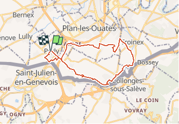
Trail Running of 14.8 km to be discovered at Geneva, Unknown, Perly-Certoux. This trail is proposed by yveshumbert.
Description
Parcours de course à pied en boucle au départ de Perly.
Itinéraire qui vous fera traverser les villages de Perly, Bardonnex, Croix-de-Rozon, Troinex, Saconnex d' Arve et Arare
Points of interest
Positioning
Country:
Switzerland
Region :
Geneva
Department/Province :
Unknown
Municipality :
Perly-Certoux
Location:
Unknown
Start:(Dec)
Start:(UTM)
275434 ; 5115617 (32T) N.
Comments
Trails nearby
![Trail On foot Carouge (GE) - De Staël - Place Verte - Photo](https://media.geolcdn.com/t/375/260/097d8cc8-85e9-4d02-9d1d-72c864b74792.jpeg&format=jpg&maxdim=2)
![On foot On foot](https://static1.geolcdn.com/sitytour/trail-icons/100.png)
De Staël - Place Verte
On foot
Easy
Carouge (GE),
Geneva,
Unknown,
Switzerland
![](/images/other/stat-length.png)
3.3 km | 3.8 km-effort
51min
![](https://static1.geolcdn.com/siteimages/upload/files/16400158638029165_repeat_loop_refresh_sync_direction_icon.png)
No
![Trail Walking Saint-Julien-en-Genevois - Le long de l'Aire (Départ Thairy) - Photo](https://media.geolcdn.com/t/375/260/aa03f1d1-2591-4501-969f-008dc11afaf6.jpg&format=jpg&maxdim=2)
![Walking Walking](https://static1.geolcdn.com/sitytour/trail-icons/101.png)
Le long de l'Aire (Départ Thairy)
Walking
Easy
Saint-Julien-en-Genevois,
Auvergne-Rhône-Alpes,
Upper Savoy,
France
![](/images/other/stat-length.png)
14.6 km | 16.4 km-effort
3h 6min
![](https://static1.geolcdn.com/siteimages/upload/files/16400158638029165_repeat_loop_refresh_sync_direction_icon.png)
Yes
![Trail Cycle Neydens - Le Saleve - Neydens - Photo](https://media.geolcdn.com/t/375/260/ext.jpg?maxdim=2&url=https%3A%2F%2Fservices.sitytrail.com%2FGeolivesWS%2FDownloadMedia.ashx%3FTrailID%3D101844%26Media%3D2130_2.jpg)
![Cycle Cycle](https://static1.geolcdn.com/sitytour/trail-icons/200.png)
Le Saleve - Neydens
Cycle
Very difficult
Neydens,
Auvergne-Rhône-Alpes,
Upper Savoy,
France
![](/images/other/stat-length.png)
31 km | 43 km-effort
3h 0min
![](https://static1.geolcdn.com/siteimages/upload/files/16400158638029165_repeat_loop_refresh_sync_direction_icon.png)
Yes
![Trail Walking Carouge (GE) - Carouge Naviguer - Photo](https://media.geolcdn.com/t/375/260/ext.jpg?maxdim=2&url=https%3A%2F%2Fstatic1.geolcdn.com%2Fsiteimages%2Fupload%2Ffiles%2F1553511878bg_sport_marche.png)
![Walking Walking](https://static1.geolcdn.com/sitytour/trail-icons/101.png)
Carouge Naviguer
Walking
Easy
Carouge (GE),
Geneva,
Unknown,
Switzerland
![](/images/other/stat-length.png)
4.6 km | 5.1 km-effort
1h 10min
![](https://static1.geolcdn.com/siteimages/upload/files/16400158638029165_repeat_loop_refresh_sync_direction_icon.png)
Yes
![Trail Walking Onex - bords du Rhône onex - Photo](https://media.geolcdn.com/t/375/260/ext.jpg?maxdim=2&url=https%3A%2F%2Fstatic1.geolcdn.com%2Fsiteimages%2Fupload%2Ffiles%2F1553511878bg_sport_marche.png)
![Walking Walking](https://static1.geolcdn.com/sitytour/trail-icons/101.png)
bords du Rhône onex
Walking
Very easy
Onex,
Geneva,
Unknown,
Switzerland
![](/images/other/stat-length.png)
10.4 km | 12.9 km-effort
2h 12min
![](https://static1.geolcdn.com/siteimages/upload/files/16400158638029165_repeat_loop_refresh_sync_direction_icon.png)
Yes
![Trail Mountain bike Confignon - confignon - La Plaine - Photo](https://media.geolcdn.com/t/375/260/ext.jpg?maxdim=2&url=https%3A%2F%2Fservices.sitytrail.com%2FGeolivesWS%2FDownloadMedia.ashx%3FTrailID%3D841017%26Media%3D4c81c5d2-4ec3-42fb-86bf-f5809a339ef1.JPG)
![Mountain bike Mountain bike](https://static1.geolcdn.com/sitytour/trail-icons/202.png)
confignon - La Plaine
Mountain bike
Very easy
Confignon,
Geneva,
Unknown,
Switzerland
![](/images/other/stat-length.png)
31 km | 36 km-effort
1h 51min
![](https://static1.geolcdn.com/siteimages/upload/files/16400158638029165_repeat_loop_refresh_sync_direction_icon.png)
Yes
![Trail Walking Lancy - 20K LBgSaL - Photo](https://media.geolcdn.com/t/375/260/ext.jpg?maxdim=2&url=https%3A%2F%2Fstatic1.geolcdn.com%2Fsiteimages%2Fupload%2Ffiles%2F1553511878bg_sport_marche.png)
![Walking Walking](https://static1.geolcdn.com/sitytour/trail-icons/101.png)
![Trail Walking Lancy - 46K LCDLL - Photo](https://media.geolcdn.com/t/375/260/ext.jpg?maxdim=2&url=https%3A%2F%2Fstatic1.geolcdn.com%2Fsiteimages%2Fupload%2Ffiles%2F1553511878bg_sport_marche.png)
![Walking Walking](https://static1.geolcdn.com/sitytour/trail-icons/101.png)
![Trail Walking Lancy - 41K LCDLL - Photo](https://media.geolcdn.com/t/375/260/ext.jpg?maxdim=2&url=https%3A%2F%2Fstatic1.geolcdn.com%2Fsiteimages%2Fupload%2Ffiles%2F1553511878bg_sport_marche.png)
![Walking Walking](https://static1.geolcdn.com/sitytour/trail-icons/101.png)