![](/images/other/stat-length.png)
![Trail Walking Pontresina - YHH096 Schruns à Tirano (6e jour) - Photo](https://media.geolcdn.com/t/1900/400/ext.pjpeg?maxdim=2&url=https%3A%2F%2Fstatic1.geolcdn.com%2Fsiteimages%2Fupload%2Ffiles%2F1553511878bg_sport_marche.png)
YHH096 Schruns à Tirano (6e jour)
yveshumbert
User
![Length](/images/other/stat-length.png)
![Max alt](https://static1.geolcdn.com/siteimages/upload/files/1508320355ic_sort_altitude_max_24dp.png)
![Uphill gradient](https://static1.geolcdn.com/siteimages/upload/files/1508320355ic_sort_den_pos_24dp.png)
![Km-Effort](/images/other/stat-length.png)
![Min alt](https://static1.geolcdn.com/siteimages/upload/files/1508320355ic_sort_altitude_min_24dp.png)
![Downhill gradient](https://static1.geolcdn.com/siteimages/upload/files/1508320355ic_sort_den_neg_24dp.png)
![Boucle](https://static1.geolcdn.com/siteimages/upload/files/16400158638029165_repeat_loop_refresh_sync_direction_icon.png)
![Walking](https://static1.geolcdn.com/sitytour/trail-icons/101.png)
6h12
Difficulty : Very difficult
![Scan this QR Code to open this trail in the SityTrail application](https://capi.geolives.com/qq0zvz2zws4bq2lad0pu/sitytour/trails/467697/qr.png?size=200)
FREE GPS app for hiking
About
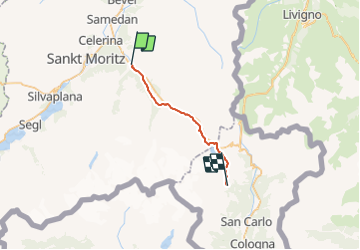
Trail Walking of 20 km to be discovered at Grisons, Maloja, Pontresina. This trail is proposed by yveshumbert.
Description
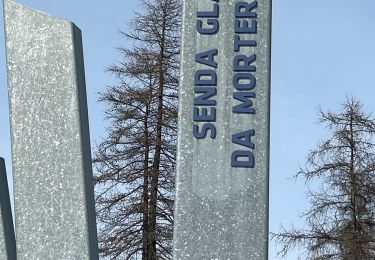
Randonnée de 8 jours au départ de Schruns (Autriche) et arrivée à Tirano (Italie). Etape # 6 Pontresina à Alp Grüm.
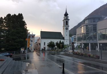
La première partie de la rando suit la rivière jusqu a Morteratsch.
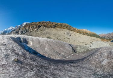
Le chemin continue par la Diavolezza, puis au col de la Bernina. On longe ensuite le lac. Finalement on redescend sur Alp Grun.
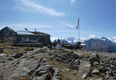
A Alp Grum on peut dormir et se restaurer a l hôtel Belvedere.
Positioning
Comments
Trails nearby
![Trail On foot Sankt Moritz - SEERUNDGANG - Photo](https://media.geolcdn.com/t/375/260/fb476387-3b2e-4236-b860-c8f411416028.jpeg&format=jpg&maxdim=2)
![On foot On foot](https://static1.geolcdn.com/sitytour/trail-icons/100.png)
On foot
![](/images/other/stat-length.png)
![](https://static1.geolcdn.com/siteimages/upload/files/16400158638029165_repeat_loop_refresh_sync_direction_icon.png)
![Trail On foot Pontresina - Muottas Muragl - Unterer Schafberg - Photo](https://media.geolcdn.com/t/375/260/fdb48e21-1399-4e12-aef6-21c111ae9825.jpeg&format=jpg&maxdim=2)
![On foot On foot](https://static1.geolcdn.com/sitytour/trail-icons/100.png)
On foot
![](/images/other/stat-length.png)
![](https://static1.geolcdn.com/siteimages/upload/files/16400158638029165_repeat_loop_refresh_sync_direction_icon.png)
![Trail On foot Samedan - Muottas Muragl - Chna. Segantini - Photo](https://media.geolcdn.com/t/375/260/d84cc500-2aaa-4cb6-8029-493b05a6f4f0.jpeg&format=jpg&maxdim=2)
![On foot On foot](https://static1.geolcdn.com/sitytour/trail-icons/100.png)
On foot
![](/images/other/stat-length.png)
![](https://static1.geolcdn.com/siteimages/upload/files/16400158638029165_repeat_loop_refresh_sync_direction_icon.png)
![Trail On foot Pontresina - Puntraschigna - Roseg - Photo](https://media.geolcdn.com/t/375/260/228522e8-b30d-4ac8-8507-135e9cf1526f.jpeg&format=jpg&maxdim=2)
![On foot On foot](https://static1.geolcdn.com/sitytour/trail-icons/100.png)
On foot
![](/images/other/stat-length.png)
![](https://static1.geolcdn.com/siteimages/upload/files/16400158638029165_repeat_loop_refresh_sync_direction_icon.png)
![Trail On foot Pontresina - Morteratsch-Pontresina - Photo](https://media.geolcdn.com/t/375/260/94324081-6d23-45ff-8174-b20d5cceabc3.jpeg&format=jpg&maxdim=2)
![On foot On foot](https://static1.geolcdn.com/sitytour/trail-icons/100.png)
On foot
![](/images/other/stat-length.png)
![](https://static1.geolcdn.com/siteimages/upload/files/16400158638029165_repeat_loop_refresh_sync_direction_icon.png)
![Trail On foot Pontresina - Morteratsch-chamanna da Boval - Photo](https://media.geolcdn.com/t/375/260/c22691e5-109a-463b-9df6-1a1d7b81abf6.jpeg&format=jpg&maxdim=2)
![On foot On foot](https://static1.geolcdn.com/sitytour/trail-icons/100.png)
On foot
![](/images/other/stat-length.png)
![](https://static1.geolcdn.com/siteimages/upload/files/16400158638029165_repeat_loop_refresh_sync_direction_icon.png)
![Trail sport Pontresina - 2024 02 21 - Photo](https://media.geolcdn.com/t/375/260/ed0f1d78-ef2c-464c-8c70-b0956e5ece8b.jpg&format=jpg&maxdim=2)
sport
![](/images/other/stat-length.png)
![](https://static1.geolcdn.com/siteimages/upload/files/16400158638029165_repeat_loop_refresh_sync_direction_icon.png)
![Trail Other activity Pontresina - y10_muottas_muragl - Photo](https://media.geolcdn.com/t/375/260/ext.jpg?maxdim=2&url=https%3A%2F%2Fstatic1.geolcdn.com%2Fsiteimages%2Fupload%2Ffiles%2F1545311037marcheuse_200dpi.jpg)
![Other activity Other activity](https://static1.geolcdn.com/sitytour/trail-icons/900.png)
Other activity
![](/images/other/stat-length.png)
![](https://static1.geolcdn.com/siteimages/upload/files/16400158638029165_repeat_loop_refresh_sync_direction_icon.png)
![Trail Walking Sankt Moritz - mtb04 - Photo](https://media.geolcdn.com/t/375/260/ext.jpg?maxdim=2&url=https%3A%2F%2Fstatic1.geolcdn.com%2Fsiteimages%2Fupload%2Ffiles%2F1553511878bg_sport_marche.png)
![Walking Walking](https://static1.geolcdn.com/sitytour/trail-icons/101.png)