Trail Walking Klosters - YHH092 Schruns à Tirano (2e jour) - Photo

YHH092 Schruns à Tirano (2e jour)

© OpenStreetMap contributors
Length
Length
12.8 km
Max alt
Max alt
1642 m
Uphill gradient
Uphill gradient
632 m
Km-Effort
Km-Effort  
19.9 km
Min alt
Min alt
1158 m
Downhill gradient
Downhill gradient
234 m
Boucle
Boucle
No
Creation date :
2015-09-03 00:00:00.0
Updated on :
2015-09-03 00:00:00.0

(0 Reviews)

Walking
Walking
4h49
Difficulty : Very difficult

Scan this QR Code to open this trail in the SityTrail application

FREE GPS app for hiking

Logo SityTrail SityTrail

IGN / Geographical institutes

Download SityTrail from the App Store Download SityTrail from Google Play

Logo SityTrail SityTrail World

The world is yours!

Download SityTrail from the App Store Download SityTrail from Google Play Download SityTrail on Huawei AppGallery

About

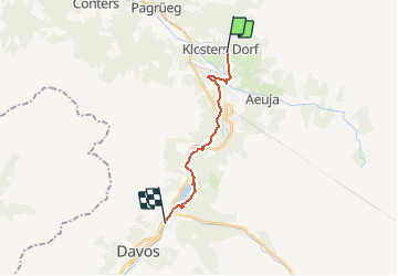
Trail Walking of 12.8 km to be discovered at Grisons, Prättigau/Davos, Klosters. This trail is proposed by yveshumbert.

Description

Randonnée de 8 jours au départ de Schruns (Autriche) et arrivée à Tirano (Italie). Etape # 2 Kloster à Davos.
De Kloster on traverse la rivière par le pont en face de la gare. Le chemin s eleve rapidement jusque a Ruti, on passe sous la voie de chemin de fer, puis on prend le chemin qui la longe.
Le chemin nous emmene au Schwarzsee, puis a unt laret. Puis une courte montée jusque a ob Laret
A Wolfgang on passe a cote de la route nationale, puis on descend on direction du lac de Davos, qu il faut contourner par la gauche.
Au bout du lac, il y a un centre de voile et un restaurant. Un petit km vous sépare encore de Davos dorf
A Davos il y a un bon choix d' hôtels pour manger et dormir

Elevation profile

Points of interest

Point of interest Davos - Schwarzsee - Photo
yveshumbert
DAVOS 
Point of interest Davos - Davosersee - Photo
yveshumbert
DAVOS 
Point of interest Davos - Davos - Photo
yveshumbert
DAVOS 

Positioning

Country:
Switzerland
Region :
Grisons
Department/Province :
Prättigau/Davos
Municipality :
Klosters
Location:
Unknown
Start:(UTM)
567029 ; 5192330 (32T) N.

Trails nearby

Trail On foot Davos - Strelapass - Parsennhütte - Photo
On foot
PRO

On foot

Easy
Davos, Grisons, Prättigau/Davos, Switzerland
8 km | 10.9 km-effort
2h 28min
No
Trail On foot Davos - CH-Gotschnagrat - Grüenhorn - Parsennfurgga - Photo
On foot
PRO

On foot

Easy
Davos, Grisons, Prättigau/Davos, Switzerland
3.8 km | 7.4 km-effort
1h 40min
No
Trail Other activity Klosters - y10_klosters_schlappiner joch - Photo
Other activity
GUIDE+

Other activity

Very easy
Klosters, Grisons, Prättigau/Davos, Switzerland
11.8 km | 21 km-effort
4h 11min
No
Trail Other activity Klosters - y10_Klosters Monbiel_Alp Spärra - Photo
Other activity
GUIDE+

Other activity

Very easy
Klosters, Grisons, Prättigau/Davos, Switzerland
13.1 km | 20 km-effort
4h 36min
Yes
Trail Other activity Davos - y10_parsenn_hoehenweg - Photo
Other activity
GUIDE+

Other activity

Very easy
Davos, Grisons, Prättigau/Davos, Switzerland
8.5 km | 14.5 km-effort
3h 24min
No
Trail Walking Klosters - walser_28 - Photo
Walking
GUIDE+

Walking

Very easy
Klosters, Grisons, Prättigau/Davos, Switzerland
13.8 km | 26 km-effort
Unknown
No


Close
My subscriptions