Trail Walking Gemeinde Sankt Gallenkirch - YHH091 Schruns à Tirano (1er jour) - Photo

YHH091 Schruns à Tirano (1er jour)

© OpenStreetMap contributors
Length
Length
13.5 km
Max alt
Max alt
2214 m
Uphill gradient
Uphill gradient
839 m
Km-Effort
Km-Effort  
26 km
Min alt
Min alt
1136 m
Downhill gradient
Downhill gradient
1101 m
Boucle
Boucle
No
Creation date :
2015-09-03 00:00:00.0
Updated on :
2015-09-03 00:00:00.0

(0 Reviews)

Walking
Walking
5h01
Difficulty : Very difficult

Scan this QR Code to open this trail in the SityTrail application

FREE GPS app for hiking

Logo SityTrail SityTrail

IGN / Geographical institutes

Download SityTrail from the App Store Download SityTrail from Google Play

Logo SityTrail SityTrail World

The world is yours!

Download SityTrail from the App Store Download SityTrail from Google Play Download SityTrail on Huawei AppGallery

About

Trail Walking of 13.5 km to be discovered at Vorarlberg, Bezirk Bludenz, Gemeinde Sankt Gallenkirch. This trail is proposed by yveshumbert.

Description

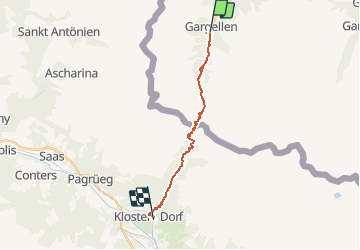
Randonnée de 8 jours au départ de Schruns (Autriche) et arrivée à Tirano (Italie). Etape # 1 Schruns à Kloster.
Prendre le bus de Schruns a Gargallen (terminus). on suit pour commencer la route, puis rapidement on prend un sentier sur la droite.  
Le chemin continue dans la vallée. Une montée courte nous amène a la frontière suisse par le col de Slappin. Le chemin redescend sur Slappin, puis on suit la route jusqu a Kloster.
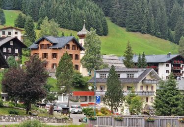
A Kloster il y a un bon choix d' hôtel pour manger et dormir

Elevation profile

Points of interest

Point of interest Gemeinde Sankt Gallenkirch - Gargellen - Photo
yveshumbert
GEMEINDE SANKT GALLENKIRCH 
Point of interest Gemeinde Sankt Gallenkirch - point 1693 - Photo
yveshumbert
GEMEINDE SANKT GALLENKIRCH 
Point of interest Gemeinde Sankt Gallenkirch - point 1776 - Photo
yveshumbert
GEMEINDE SANKT GALLENKIRCH 
Point of interest Gemeinde Sankt Gallenkirch - point 1818 - Photo
yveshumbert
GEMEINDE SANKT GALLENKIRCH 
Point of interest Gemeinde Sankt Gallenkirch - Schlappiner Joch - Photo
yveshumbert
GEMEINDE SANKT GALLENKIRCH 
Point of interest Klosters - Schlappin - Photo
yveshumbert
KLOSTERS 
Point of interest Klosters - Point 1982 - Photo
yveshumbert
KLOSTERS 
Point of interest Klosters - Kloster - Photo
yveshumbert
KLOSTERS 

Positioning

Country:
Austria
Region :
Vorarlberg
Department/Province :
Bezirk Bludenz
Municipality :
Gemeinde Sankt Gallenkirch
Location:
Unknown
Start:(UTM)
569840 ; 5202245 (32T) N.

Trails nearby

Trail On foot Gemeinde Sankt Gallenkirch - Gargellen:Schmugglersroute (PVDB) - Photo
On foot
GUIDE
Peter.vdbergh

On foot

Difficult
Gemeinde Sankt Gallenkirch, Vorarlberg, Bezirk Bludenz, Austria
14.3 km | 24 km-effort
7h 12min
No
Trail Walking Luzein - wa17 - Photo
Walking
GUIDE+

Walking

Very easy
Luzein, Grisons, Prättigau/Davos, Switzerland
12 km | 22 km-effort
Unknown
Yes
Trail Walking Luzein - Partnun - Alpenrundweg - Photo
Walking
GUIDE+

Walking

Very easy
Luzein, Grisons, Prättigau/Davos, Switzerland
11 km | 20 km-effort
Unknown
Yes
Trail Walking Luzein - Sulzfluh, Rotspitz, Gruobenpass, Partnunsee - Photo
Walking
perenhout

Walking

Medium
Luzein, Grisons, Prättigau/Davos, Switzerland
11.2 km | 21 km-effort
5h 25min
Yes
Trail Walking Gemeinde Sankt Gallenkirch - 21 09 04 - Photo
Walking
jmbilger

Walking

Easy
Gemeinde Sankt Gallenkirch, Vorarlberg, Bezirk Bludenz, Austria
3.8 km | 6 km-effort
1h 6min
No
Trail Walking Gemeinde Sankt Gallenkirch - 21 09 03 schafberg - Gargellen  - Photo
Walking
jmbilger

Walking

Easy
Gemeinde Sankt Gallenkirch, Vorarlberg, Bezirk Bludenz, Austria
2 km | 2.7 km-effort
1h 35min
No


Close
My subscriptions