Trail Walking Rochebrune - YHH085 Rochebrune, les 3 cols - Photo

YHH085 Rochebrune, les 3 cols

© OpenStreetMap contributors
Length
Length
9.1 km
Max alt
Max alt
740 m
Uphill gradient
Uphill gradient
322 m
Km-Effort
Km-Effort  
13.4 km
Min alt
Min alt
534 m
Downhill gradient
Downhill gradient
336 m
Boucle
Boucle
Yes
Creation date :
2015-09-03 00:00:00.0
Updated on :
2015-09-03 00:00:00.0

(0 Reviews)

Walking
Walking
3h20
Difficulty : Difficult

Scan this QR Code to open this trail in the SityTrail application

FREE GPS app for hiking

Logo SityTrail SityTrail

IGN / Geographical institutes

Download SityTrail from the App Store Download SityTrail from Google Play

Logo SityTrail SityTrail World

The world is yours!

Download SityTrail from the App Store Download SityTrail from Google Play Download SityTrail on Huawei AppGallery

About

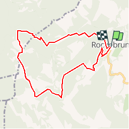
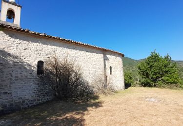
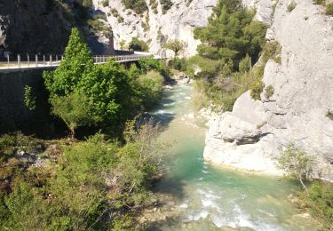
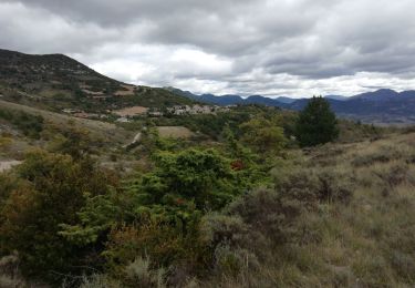
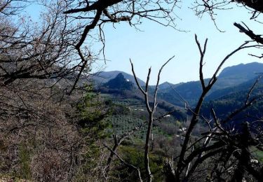
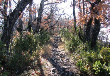
Trail Walking of 9.1 km to be discovered at Auvergne-Rhône-Alpes, Drôme, Rochebrune. This trail is proposed by yveshumbert.

Description

Randonnée d' une journée en boucle au départ du Rochebrune.Très jolie rando. On monte gentiment par un chemin large, qui se rétrécit pour arriver au col de la Croix. On suit ensuite la route jusqu' au col des Lantons. Ensuite on descend sur un chemin carossable jusqu' à un gite d' étape, où ils vendent des fromages de chèvre produit sur place. On continue ensuite de descendre sur le chemin carossable, mais il ne faut pas manquer le petit sentier qui montera sur votre droite, qui vous amménera au col Serriès. De là toujours sur un chemin étroit on suit la rive gauche du vallon. Arrivé dans le creux du Vallon une courte remontée vous ramménera à Rochebrune. Ne pas manquer de visiter ce joli village et sa chapelle

Elevation profile

Positioning

Country:
France
Region :
Auvergne-Rhône-Alpes
Department/Province :
Drôme
Municipality :
Rochebrune
Location:
Unknown
Start:(UTM)
678984 ; 4911660 (31T) N.

Trails nearby

Trail Walking Les Pilles - NYONS (Monts d'Autuche) - Photo
Walking
GerardBouche

Walking

Medium
(1)
Les Pilles, Auvergne-Rhône-Alpes, Drôme, France
9.1 km | 17.9 km-effort
3h 35min
Yes
Trail Walking Bénivay-Ollon - Balade en Baronnies - Propiac - Photo
Walking
tracegps

Walking

Medium
(2)
Bénivay-Ollon, Auvergne-Rhône-Alpes, Drôme, France
9.8 km | 15.4 km-effort
3h 0min
Yes
Trail Road bike Sainte-Jalle - Col d’Ey depuis Sainte Jalle via Rochebrune  - Photo
Road bike
Pierre Jongen

Road bike

Medium
Sainte-Jalle, Auvergne-Rhône-Alpes, Drôme, France
18.8 km | 24 km-effort
1h 55min
Yes
Trail Walking Arpavon - BruBer-Arpavon : ND Consolation - Photo
Walking
Bruno Berlemont

Walking

Medium
Arpavon, Auvergne-Rhône-Alpes, Drôme, France
5.5 km | 8.2 km-effort
1h 30min
Yes
Trail Walking Buis-les-Baronnies - Buis - Baume Noire - Photo
Walking
MarcLEBARON

Walking

Difficult
Buis-les-Baronnies, Auvergne-Rhône-Alpes, Drôme, France
16.7 km | 27 km-effort
5h 30min
No
Trail Walking Sainte-Jalle - GRP Baronnies Ste Jalle Arpavon 18km - Photo
Walking
GUIDE
thonyc

Walking

Medium
Sainte-Jalle, Auvergne-Rhône-Alpes, Drôme, France
18 km | 27 km-effort
5h 32min
Yes
Trail Mountain bike Les Pilles - run bike nyons - Photo
Mountain bike
sebout2

Mountain bike

Very difficult
Les Pilles, Auvergne-Rhône-Alpes, Drôme, France
24 km | 39 km-effort
4h 26min
Yes
Trail Walking Beauvoisin - Le Gros Moure par Bénivay Ollon  - Photo
Walking
tracegps

Walking

Medium
Beauvoisin, Auvergne-Rhône-Alpes, Drôme, France
16 km | 26 km-effort
4h 0min
Yes
Trail Mountain bike Les Pilles - Les monts d'Autuche - Photo
Mountain bike
tracegps

Mountain bike

Very difficult
(1)
Les Pilles, Auvergne-Rhône-Alpes, Drôme, France
22 km | 35 km-effort
3h 0min
Yes


Close
My subscriptions