![](/images/other/stat-length.png)
![Trail Walking Plévenon - tour du Cap frehel à port la latte - Photo](https://media.geolcdn.com/t/1900/400/ext.pjpeg?maxdim=2&url=https%3A%2F%2Fstatic1.geolcdn.com%2Fsiteimages%2Fupload%2Ffiles%2F1553511878bg_sport_marche.png)
tour du Cap frehel à port la latte
olivier78000
User
![Length](/images/other/stat-length.png)
Length
15.2 km
![Max alt](https://static1.geolcdn.com/siteimages/upload/files/1508320355ic_sort_altitude_max_24dp.png)
Max alt
78 m
![Uphill gradient](https://static1.geolcdn.com/siteimages/upload/files/1508320355ic_sort_den_pos_24dp.png)
Uphill gradient
275 m
![Km-Effort](/images/other/stat-length.png)
Km-Effort
18.9 km
![Min alt](https://static1.geolcdn.com/siteimages/upload/files/1508320355ic_sort_altitude_min_24dp.png)
Min alt
12 m
![Downhill gradient](https://static1.geolcdn.com/siteimages/upload/files/1508320355ic_sort_den_neg_24dp.png)
Downhill gradient
272 m
![Boucle](https://static1.geolcdn.com/siteimages/upload/files/16400158638029165_repeat_loop_refresh_sync_direction_icon.png)
Boucle
Yes
Creation date :
2015-09-02 00:00:00.0
Updated on :
2015-09-02 00:00:00.0
![Walking](https://static1.geolcdn.com/sitytour/trail-icons/101.png)
4h07
Difficulty : Easy
![Scan this QR Code to open this trail in the SityTrail application](https://capi.geolives.com/qq0zvz2zws4bq2lad0pu/sitytour/trails/467305/qr.png?size=200)
FREE GPS app for hiking
About
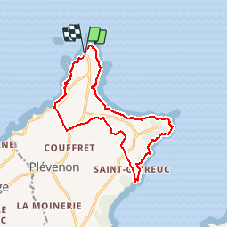
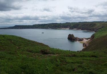
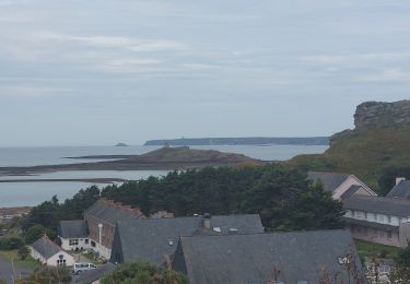
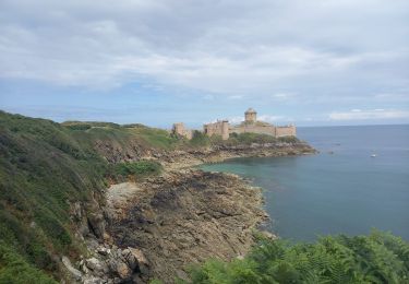
Trail Walking of 15.2 km to be discovered at Brittany, Côtes-d'Armor, Plévenon. This trail is proposed by olivier78000.
Description
Magnifique randonnée. Qui longe la mer et s'engouffre dans les bois et forêts. Attention à port grehel. Bien suivre le GR34. A faire absolument.
Positioning
Country:
France
Region :
Brittany
Department/Province :
Côtes-d'Armor
Municipality :
Plévenon
Location:
Unknown
Start:(Dec)
Start:(UTM)
550070 ; 5392478 (30U) N.
Comments
Trails nearby
![Trail Walking Plévenon - cap Frehel - Photo](https://media.geolcdn.com/t/375/260/ext.jpg?maxdim=2&url=https%3A%2F%2Fservices.sitytrail.com%2FGeolivesWS%2FDownloadMedia.ashx%3FTrailID%3D733815%26Media%3Dfix__20170416142659.jpg)
![Walking Walking](https://static1.geolcdn.com/sitytour/trail-icons/101.png)
cap Frehel
Walking
Medium
(1)
Plévenon,
Brittany,
Côtes-d'Armor,
France
![](/images/other/stat-length.png)
17.2 km | 21 km-effort
4h 43min
![](https://static1.geolcdn.com/siteimages/upload/files/16400158638029165_repeat_loop_refresh_sync_direction_icon.png)
Yes
![Walking Walking](https://static1.geolcdn.com/sitytour/trail-icons/101.png)
SityTrail - GR 34 Pléhérel Plage -- Pléneuf Val André
Walking
Very difficult
Fréhel,
Brittany,
Côtes-d'Armor,
France
![](/images/other/stat-length.png)
20 km | 25 km-effort
5h 35min
![](https://static1.geolcdn.com/siteimages/upload/files/16400158638029165_repeat_loop_refresh_sync_direction_icon.png)
No
![Walking Walking](https://static1.geolcdn.com/sitytour/trail-icons/101.png)
SityTrail - GR 34 St Cast le Guildo -- Le Petit Trécelin
Walking
Very difficult
Saint-Cast-le-Guildo,
Brittany,
Côtes-d'Armor,
France
![](/images/other/stat-length.png)
18.9 km | 24 km-effort
5h 23min
![](https://static1.geolcdn.com/siteimages/upload/files/16400158638029165_repeat_loop_refresh_sync_direction_icon.png)
No
![Trail Walking Plévenon - Fort La Latte - 2017 06 22 - Photo](https://media.geolcdn.com/t/375/260/8294287f-801d-42c8-995a-de2105ee0c15.jpg&format=jpg&maxdim=2)
![Walking Walking](https://static1.geolcdn.com/sitytour/trail-icons/101.png)
Fort La Latte - 2017 06 22
Walking
Very easy
Plévenon,
Brittany,
Côtes-d'Armor,
France
![](/images/other/stat-length.png)
3.1 km | 4 km-effort
1h 0min
![](https://static1.geolcdn.com/siteimages/upload/files/16400158638029165_repeat_loop_refresh_sync_direction_icon.png)
Yes
![Trail Other activity Plévenon - Cap Frehel Fort la latte - Photo](https://media.geolcdn.com/t/375/260/ext.jpg?maxdim=2&url=https%3A%2F%2Fstatic1.geolcdn.com%2Fsiteimages%2Fupload%2Ffiles%2F1545311037marcheuse_200dpi.jpg)
![Other activity Other activity](https://static1.geolcdn.com/sitytour/trail-icons/900.png)
Cap Frehel Fort la latte
Other activity
Medium
(1)
Plévenon,
Brittany,
Côtes-d'Armor,
France
![](/images/other/stat-length.png)
12.9 km | 15.6 km-effort
4h 41min
![](https://static1.geolcdn.com/siteimages/upload/files/16400158638029165_repeat_loop_refresh_sync_direction_icon.png)
Yes
![Trail Walking Plévenon - Cap Frehel - Photo](https://media.geolcdn.com/t/375/260/017eb03e-444e-4bbb-a7dd-b551f9a78235.jpg&format=jpg&maxdim=2)
![Walking Walking](https://static1.geolcdn.com/sitytour/trail-icons/101.png)
Cap Frehel
Walking
Easy
Plévenon,
Brittany,
Côtes-d'Armor,
France
![](/images/other/stat-length.png)
12.1 km | 14.2 km-effort
4h 28min
![](https://static1.geolcdn.com/siteimages/upload/files/16400158638029165_repeat_loop_refresh_sync_direction_icon.png)
Yes
![Trail Walking Fréhel - J4G2 - Photo](https://media.geolcdn.com/t/375/260/9526b197-a435-4e56-a4d2-07969405d323.jpg&format=jpg&maxdim=2)
![Walking Walking](https://static1.geolcdn.com/sitytour/trail-icons/101.png)
![Trail Walking Plévenon - GR_34_BF_12_Plevenon_Erquy_20230818 - Photo](https://media.geolcdn.com/t/375/260/2759aa01-3305-4693-920a-9eec8c0be183.jpg&format=jpg&maxdim=2)
![Walking Walking](https://static1.geolcdn.com/sitytour/trail-icons/101.png)
GR_34_BF_12_Plevenon_Erquy_20230818
Walking
Easy
Plévenon,
Brittany,
Côtes-d'Armor,
France
![](/images/other/stat-length.png)
15.5 km | 18.7 km-effort
3h 44min
![](https://static1.geolcdn.com/siteimages/upload/files/16400158638029165_repeat_loop_refresh_sync_direction_icon.png)
No
![Trail Walking Plévenon - Cap Fréhel et Fort la Latte 5.7.23 - Photo](https://media.geolcdn.com/t/375/260/17bf9c44-d657-48b0-aeb2-b0316457cb2f.jpg&format=jpg&maxdim=2)
![Walking Walking](https://static1.geolcdn.com/sitytour/trail-icons/101.png)
Cap Fréhel et Fort la Latte 5.7.23
Walking
Easy
Plévenon,
Brittany,
Côtes-d'Armor,
France
![](/images/other/stat-length.png)
13.4 km | 16 km-effort
3h 25min
![](https://static1.geolcdn.com/siteimages/upload/files/16400158638029165_repeat_loop_refresh_sync_direction_icon.png)
Yes