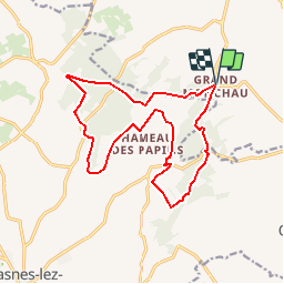
![](/images/other/stat-length.png)
![Trail Walking Ellezelles - Pays des Collines - Grand Montchaut - Photo](https://media.geolcdn.com/t/1900/400/ext.pjpeg?maxdim=2&url=https%3A%2F%2Fstatic1.geolcdn.com%2Fsiteimages%2Fupload%2Ffiles%2F1553511878bg_sport_marche.png)
Pays des Collines - Grand Montchaut
elsdewilde
User
![Length](/images/other/stat-length.png)
![Max alt](https://static1.geolcdn.com/siteimages/upload/files/1508320355ic_sort_altitude_max_24dp.png)
![Uphill gradient](https://static1.geolcdn.com/siteimages/upload/files/1508320355ic_sort_den_pos_24dp.png)
![Km-Effort](/images/other/stat-length.png)
![Min alt](https://static1.geolcdn.com/siteimages/upload/files/1508320355ic_sort_altitude_min_24dp.png)
![Downhill gradient](https://static1.geolcdn.com/siteimages/upload/files/1508320355ic_sort_den_neg_24dp.png)
![Boucle](https://static1.geolcdn.com/siteimages/upload/files/16400158638029165_repeat_loop_refresh_sync_direction_icon.png)
![Walking](https://static1.geolcdn.com/sitytour/trail-icons/101.png)
4h03
Difficulty : Unknown
![Scan this QR Code to open this trail in the SityTrail application](https://capi.geolives.com/qq0zvz2zws4bq2lad0pu/sitytour/trails/465168/qr.png?size=200)
FREE GPS app for hiking
About
Trail Walking of 15 km to be discovered at Wallonia, Hainaut, Ellezelles. This trail is proposed by elsdewilde.
Description
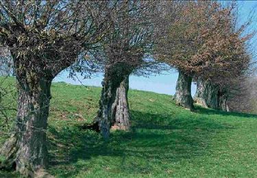
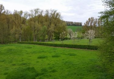
Pittige gps-wandeling van Westwandelingen door het Pays des Collines. Het Pays des Collines bestaat uit de gemeentes Ellezelles, Flobecq, Frasnes-lez-Anvaing en Mont-de-l'Enclus en heeft een uitgesproken eigen identiteit. De streek kan bogen op een rijk verleden en geniet van een eigen specifieke geomorfologie. Het is een golvend landschap met veel bossen en pittoreske dorpjes. Deze wandeling start in Grand Monchaut, een piepklein dorpje. Meteen is de toon gezet voor wat komen zal: stilte, veel groen en heuvels. De wandeling gaat op en af langs verkeersarme wegen, bospaden en onverharde weggetjes. Laat je bij het kruispunt aan het 'Bois d'Hubermont' niet afschrikken door de bordjes 'Propriété Privée, défense d'entrer', dit geldt enkel voor het bos, niet voor het pad dat er door loopt. Wat verder na de scherpe bocht naar links kom je er weer enkele tegen, ook hier is de doorgang geen probleem, er wordt enkel verwacht dat je op het pad blijft. Er zitten enkele stevige kuitenbijters in deze wandeling, maar je inzet wordt hiervoor beloond met enkele schitterende uitzichten. Een 4-sterrentocht in een prachtige streek. Totale stijging: 245 meter.
Positioning
Comments
Trails nearby
![Trail Walking Ellezelles - RB-Ha-02 - Ellezelles - 2024-10-29 - Photo](https://media.geolcdn.com/t/375/260/ext.jpg?maxdim=2&url=https%3A%2F%2Fservices.sitytrail.com%2FGeolivesWS%2FDownloadMedia.ashx%3FTrailID%3D217832%26Media%3D2f63cbc9-67e0-4d65-89f9-544523dd5718.jpg)
![Walking Walking](https://static1.geolcdn.com/sitytour/trail-icons/101.png)
Walking
![](/images/other/stat-length.png)
![](https://static1.geolcdn.com/siteimages/upload/files/16400158638029165_repeat_loop_refresh_sync_direction_icon.png)
![Trail Electric bike Ronse - Ellezelles par petits chemins pittoresques - Photo](https://media.geolcdn.com/t/375/260/e0aa3d15-f60d-4f83-a5a3-a0f3e8c9900b.jpg&format=jpg&maxdim=2)
![Electric bike Electric bike](https://static1.geolcdn.com/sitytour/trail-icons/205.png)
Electric bike
![](/images/other/stat-length.png)
![](https://static1.geolcdn.com/siteimages/upload/files/16400158638029165_repeat_loop_refresh_sync_direction_icon.png)
![Trail Mountain bike Ronse - Vers Musiekbos - Photo](https://media.geolcdn.com/t/375/260/ext.jpg?maxdim=2&url=https%3A%2F%2Fservices.sitytrail.com%2FGeolivesWS%2FDownloadMedia.ashx%3FTrailID%3D412567%26Media%3Dfix__20150426141940.jpg)
![Mountain bike Mountain bike](https://static1.geolcdn.com/sitytour/trail-icons/202.png)
Mountain bike
![](/images/other/stat-length.png)
![](https://static1.geolcdn.com/siteimages/upload/files/16400158638029165_repeat_loop_refresh_sync_direction_icon.png)
![Trail Walking Ellezelles - Le sentier de l'étrange - Photo](https://media.geolcdn.com/t/375/260/ext.jpg?maxdim=2&url=https%3A%2F%2Fservices.sitytrail.com%2FGeolivesWS%2FDownloadMedia.ashx%3FTrailID%3D202842%26Media%3Dfd094432-4170-43a7-b091-423977983591.jpg)
![Walking Walking](https://static1.geolcdn.com/sitytour/trail-icons/101.png)
Walking
![](/images/other/stat-length.png)
![](https://static1.geolcdn.com/siteimages/upload/files/16400158638029165_repeat_loop_refresh_sync_direction_icon.png)
![Trail Equestrian Flobecq - Loop of Flobecq - Photo](https://media.geolcdn.com/t/375/260/ext.jpg?maxdim=2&url=https%3A%2F%2Fpivotmedia.tourismewallonie.be%2FANX-02-000EIV%2FANX-02-000EIV.jpg)
![Equestrian Equestrian](https://static1.geolcdn.com/sitytour/trail-icons/300.png)
Equestrian
![](/images/other/stat-length.png)
![](https://static1.geolcdn.com/siteimages/upload/files/16400158638029165_repeat_loop_refresh_sync_direction_icon.png)
![Trail Equestrian Ellezelles - Loop of Ellezelles - Photo](https://media.geolcdn.com/t/375/260/ext.jpg?maxdim=2&url=https%3A%2F%2Fpivotmedia.tourismewallonie.be%2FANX-02-020D-00MD%2FANX-02-020D-00MD.jpg)
![Equestrian Equestrian](https://static1.geolcdn.com/sitytour/trail-icons/300.png)
Equestrian
![](/images/other/stat-length.png)
![](https://static1.geolcdn.com/siteimages/upload/files/16400158638029165_repeat_loop_refresh_sync_direction_icon.png)
![Trail On foot Ellezelles - Walk Jean Nature - Photo](https://media.geolcdn.com/t/375/260/ext.jpg?maxdim=2&url=https%3A%2F%2Fpivotmedia.tourismewallonie.be%2FANX-02-03ZF-0001%2FANX-02-03ZF-0001.JPG)
![On foot On foot](https://static1.geolcdn.com/sitytour/trail-icons/100.png)
On foot
![](/images/other/stat-length.png)
![](https://static1.geolcdn.com/siteimages/upload/files/16400158638029165_repeat_loop_refresh_sync_direction_icon.png)
![Trail Mountain bike Frasnes-lez-Anvaing - Across woodland and countryside - Photo](https://media.geolcdn.com/t/375/260/ext.jpg?maxdim=2&url=https%3A%2F%2Fpivotmedia.tourismewallonie.be%2FANX-02-000EX4%2FANX-02-000EX4.jpg)
![Mountain bike Mountain bike](https://static1.geolcdn.com/sitytour/trail-icons/202.png)
Mountain bike
![](/images/other/stat-length.png)
![](https://static1.geolcdn.com/siteimages/upload/files/16400158638029165_repeat_loop_refresh_sync_direction_icon.png)
![Trail On foot Frasnes-lez-Anvaing - La Balade des Hiboux - Photo](https://media.geolcdn.com/t/375/260/ext.jpg?maxdim=2&url=https%3A%2F%2Fpivotmedia.tourismewallonie.be%2FANX-02-000END%2FANX-02-000END.jpg)
![On foot On foot](https://static1.geolcdn.com/sitytour/trail-icons/100.png)
On foot
![](/images/other/stat-length.png)
![](https://static1.geolcdn.com/siteimages/upload/files/16400158638029165_repeat_loop_refresh_sync_direction_icon.png)