Trail Walking Saint-Martin-la-Méanne - St Martin la Meanne - Argentat par les gorges - Photo

St Martin la Meanne - Argentat par les gorges

 grageot
grageot

User

© OpenStreetMap contributors
Length
Length
19.7 km
Max alt
Max alt
514 m
Uphill gradient
Uphill gradient
613 m
Km-Effort
Km-Effort  
29 km
Min alt
Min alt
178 m
Downhill gradient
Downhill gradient
915 m
Boucle
Boucle
No
Creation date :
2015-09-03 00:00:00.0
Updated on :
2015-09-03 00:00:00.0

(0 Reviews)

Walking
Walking
6h00
Difficulty : Medium

Scan this QR Code to open this trail in the SityTrail application

FREE GPS app for hiking

Logo SityTrail SityTrail

IGN / Geographical institutes

Download SityTrail from the App Store Download SityTrail from Google Play

Logo SityTrail SityTrail World

The world is yours!

Download SityTrail from the App Store Download SityTrail from Google Play Download SityTrail on Huawei AppGallery

About

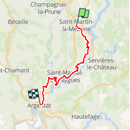
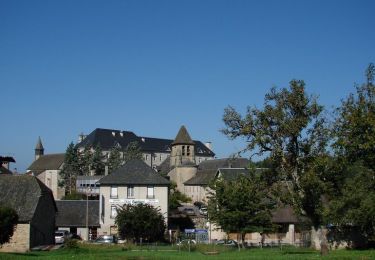
Trail Walking of 19.7 km to be discovered at New Aquitaine, Corrèze, Saint-Martin-la-Méanne. This trail is proposed by grageot.

Description

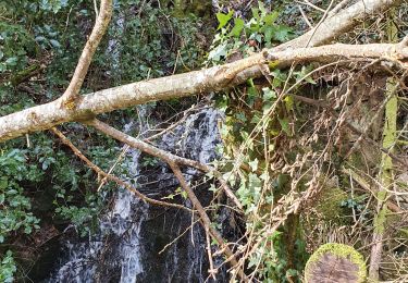
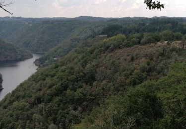
Dernier tronçon du GR de  "la Dordogne de villages en barrages" fin du GR des gorges de la Dordogne -  balisage jaune et blanc pas toujours visible. Après le Roc Castel descendre directement dans la pense, on retrouve rapidement le sentier.A faire plutôt au printemps pour voir les gorges et le barrage.

Elevation profile

Positioning

Country:
France
Region :
New Aquitaine
Department/Province :
Corrèze
Municipality :
Saint-Martin-la-Méanne
Location:
Unknown
Start:(UTM)
420555 ; 5002232 (31T) N.

Trails nearby

Trail Walking Servières-le-Château - Les chapelles - Servières le Château - Photo
Walking
tracegps

Walking

Difficult
(2)
Servières-le-Château, New Aquitaine, Corrèze, France
7.3 km | 12.2 km-effort
3h 0min
Yes
Trail Walking Saint-Martin-la-Méanne - St-Martin la Méanne_St- Martial-Entraygues - Photo
Walking
viam19

Walking

Difficult
Saint-Martin-la-Méanne, New Aquitaine, Corrèze, France
10.6 km | 16.4 km-effort
6h 18min
No
Trail Car Servières-le-Château - gorges de la Dordogne  - Photo
Car
Django44380

Car

Medium
Servières-le-Château, New Aquitaine, Corrèze, France
130 km | 173 km-effort
6h 51min
No
Trail Walking La Roche-Canillac - La Roche-Canillac  Moulin de la Grave - Photo
Walking
grageot

Walking

Medium
(1)
La Roche-Canillac, New Aquitaine, Corrèze, France
12.5 km | 19.3 km-effort
3h 20min
Yes
Trail Walking Servières-le-Château - Correze - Servieres-le-Chateau Camping du lac de Feyt 16km 100m - Photo
Walking
RandoVal

Walking

Very easy
Servières-le-Château, New Aquitaine, Corrèze, France
16.5 km | 21 km-effort
Unknown
Yes
Trail Walking Champagnac-la-Prune - champagnac la prune  - Photo
Walking
miremi

Walking

Medium
Champagnac-la-Prune, New Aquitaine, Corrèze, France
8.3 km | 11 km-effort
3h 8min
No
Trail Trail Servières-le-Château - Trail Hiver trail 15 km Servieres le Chateau  - Photo
Trail
Sherpat31

Trail

Medium
Servières-le-Château, New Aquitaine, Corrèze, France
14.3 km | 21 km-effort
1h 53min
Yes
Trail Walking Gumond - la borde - Photo
Walking
chanac les mines

Walking

Very difficult
Gumond, New Aquitaine, Corrèze, France
14.7 km | 19.3 km-effort
3h 48min
Yes
Trail Walking Gumond - Etang Laborde laroche - Photo
Walking
fanclem

Walking

Very difficult
Gumond, New Aquitaine, Corrèze, France
15 km | 19.6 km-effort
3h 54min
Yes


Close
My subscriptions