![](/images/other/stat-length.png)
![Trail Walking Lanchères - maison de l'oiseau - Photo](https://media.geolcdn.com/t/1900/400/ext.pjpeg?maxdim=2&url=https%3A%2F%2Fservices.sitytrail.com%2FGeolivesWS%2FDownloadMedia.ashx%3FTrailID%3D462656%26Media%3Dfix__20150822180137.jpg)
maison de l'oiseau
Brindille
User
![Length](/images/other/stat-length.png)
![Max alt](https://static1.geolcdn.com/siteimages/upload/files/1508320355ic_sort_altitude_max_24dp.png)
![Uphill gradient](https://static1.geolcdn.com/siteimages/upload/files/1508320355ic_sort_den_pos_24dp.png)
![Km-Effort](/images/other/stat-length.png)
![Min alt](https://static1.geolcdn.com/siteimages/upload/files/1508320355ic_sort_altitude_min_24dp.png)
![Downhill gradient](https://static1.geolcdn.com/siteimages/upload/files/1508320355ic_sort_den_neg_24dp.png)
![Boucle](https://static1.geolcdn.com/siteimages/upload/files/16400158638029165_repeat_loop_refresh_sync_direction_icon.png)
![Walking](https://static1.geolcdn.com/sitytour/trail-icons/101.png)
2h33
Difficulty : Unknown
![Scan this QR Code to open this trail in the SityTrail application](https://capi.geolives.com/qq0zvz2zws4bq2lad0pu/sitytour/trails/462656/qr.png?size=200)
FREE GPS app for hiking
About
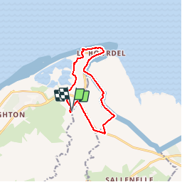
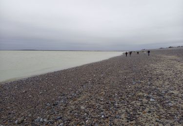
Trail Walking of 9.8 km to be discovered at Hauts-de-France, Somme, Lanchères. This trail is proposed by Brindille.
Description
Départ de Sallenelle à la maison de l'oiseau.
Au point 6 il est possible de longer la mer sur les galets jusqu'au poste d'observation.
Au point 12 bien bifurquer à droite pour rejoindre un large chemin qui mène à la D3, la traverser et suivre la piste cyclable jusqu'au rond point. Tourner sur la gauche et longer le bras d'eau en espérant que le chemin soit entretenu car il ne l'est pas toujours. Continuer tout droit pour rejoindre le petit pont de bois qui mène à la maison de l'oiseau, donc au point de départ.
Positioning
Comments
Trails nearby
![Trail Walking Cayeux-sur-Mer - Le Hourdel V2 - Photo](https://media.geolcdn.com/t/375/260/ext.jpg?maxdim=2&url=https%3A%2F%2Fservices.sitytrail.com%2FGeolivesWS%2FDownloadMedia.ashx%3FTrailID%3D108609%26Media%3D1517_1.jpg)
![Walking Walking](https://static1.geolcdn.com/sitytour/trail-icons/101.png)
Walking
![](/images/other/stat-length.png)
![](https://static1.geolcdn.com/siteimages/upload/files/16400158638029165_repeat_loop_refresh_sync_direction_icon.png)
![Trail Walking Saint-Valery-sur-Somme - w-frankrijk-over-dijken-en-kwelders - Photo](https://media.geolcdn.com/t/375/260/ext.jpg?maxdim=2&url=https%3A%2F%2Fstatic1.geolcdn.com%2Fsiteimages%2Fupload%2Ffiles%2F1553511878bg_sport_marche.png)
![Walking Walking](https://static1.geolcdn.com/sitytour/trail-icons/101.png)
Walking
![](/images/other/stat-length.png)
![](https://static1.geolcdn.com/siteimages/upload/files/16400158638029165_repeat_loop_refresh_sync_direction_icon.png)
![Trail Mountain bike Cayeux-sur-Mer - Cayeux-sur-Mer Cyclisme - Photo](https://media.geolcdn.com/t/375/260/dfc5e36a-a876-4158-8d07-2ca8055ddf3f.jpeg&format=jpg&maxdim=2)
![Mountain bike Mountain bike](https://static1.geolcdn.com/sitytour/trail-icons/202.png)
Mountain bike
![](/images/other/stat-length.png)
![](https://static1.geolcdn.com/siteimages/upload/files/16400158638029165_repeat_loop_refresh_sync_direction_icon.png)
![Trail Walking Saint-Valery-sur-Somme - Baie de Somme - Photo](https://media.geolcdn.com/t/375/260/cb6e4d30-4f7e-42c4-9ece-16b315675a3a.jpg&format=jpg&maxdim=2)
![Walking Walking](https://static1.geolcdn.com/sitytour/trail-icons/101.png)
Walking
![](/images/other/stat-length.png)
![](https://static1.geolcdn.com/siteimages/upload/files/16400158638029165_repeat_loop_refresh_sync_direction_icon.png)
![Trail Walking Cayeux-sur-Mer - entre le Hourdel et Cailleux - Photo](https://media.geolcdn.com/t/375/260/b237faa7-5642-4003-8111-9e6140f1adf8.jpg&format=jpg&maxdim=2)
![Walking Walking](https://static1.geolcdn.com/sitytour/trail-icons/101.png)
Walking
![](/images/other/stat-length.png)
![](https://static1.geolcdn.com/siteimages/upload/files/16400158638029165_repeat_loop_refresh_sync_direction_icon.png)
![Trail Walking Cayeux-sur-Mer - Crayeux sur mer - Photo](https://media.geolcdn.com/t/375/260/e74086ef-56e3-4ae1-8a72-f13407de6209.jpg&format=jpg&maxdim=2)
![Walking Walking](https://static1.geolcdn.com/sitytour/trail-icons/101.png)
Walking
![](/images/other/stat-length.png)
![](https://static1.geolcdn.com/siteimages/upload/files/16400158638029165_repeat_loop_refresh_sync_direction_icon.png)
![Trail On foot Le Crotoy - Balade au Crotoy - Photo](https://media.geolcdn.com/t/375/260/26de7ff6-9c66-49a7-b6c3-e3a464c722c9.jpeg&format=jpg&maxdim=2)
![On foot On foot](https://static1.geolcdn.com/sitytour/trail-icons/100.png)
On foot
![](/images/other/stat-length.png)
![](https://static1.geolcdn.com/siteimages/upload/files/16400158638029165_repeat_loop_refresh_sync_direction_icon.png)
![Trail On foot Cayeux-sur-Mer - Le Hourdel - Photo](https://media.geolcdn.com/t/375/260/e02b6736-5598-4803-9f59-ea4f4aaa2d0c.jpeg&format=jpg&maxdim=2)
![On foot On foot](https://static1.geolcdn.com/sitytour/trail-icons/100.png)
On foot
![](/images/other/stat-length.png)
![](https://static1.geolcdn.com/siteimages/upload/files/16400158638029165_repeat_loop_refresh_sync_direction_icon.png)
![Trail Walking Cayeux-sur-Mer - Pointe du Hourdel (Baie de Somme) - Photo](https://media.geolcdn.com/t/375/260/f4197274-2126-494d-824f-85d2cdf45160.jpg&format=jpg&maxdim=2)
![Walking Walking](https://static1.geolcdn.com/sitytour/trail-icons/101.png)
Walking
![](/images/other/stat-length.png)
![](https://static1.geolcdn.com/siteimages/upload/files/16400158638029165_repeat_loop_refresh_sync_direction_icon.png)