Trail Walking Sixt-Fer-à-Cheval - Le Buet par Grenairon - Photo
© OpenStreetMap contributors
Length
Length
25 km
Max alt
Max alt
3083 m
Uphill gradient
Uphill gradient
2112 m
Km-Effort
Km-Effort  
53 km
Min alt
Min alt
1133 m
Downhill gradient
Downhill gradient
1855 m
Boucle
Boucle
No
Creation date :
2015-08-22 00:00:00.0
Updated on :
2015-08-22 00:00:00.0

(1 Reviews)

Walking
Walking
10h32
Difficulty : Difficult

Scan this QR Code to open this trail in the SityTrail application

FREE GPS app for hiking

Logo SityTrail SityTrail

IGN / Geographical institutes

Download SityTrail from the App Store Download SityTrail from Google Play

Logo SityTrail SityTrail World

The world is yours!

Download SityTrail from the App Store Download SityTrail from Google Play Download SityTrail on Huawei AppGallery

About

Trail Walking of 25 km to be discovered at Auvergne-Rhône-Alpes, Upper Savoy, Sixt-Fer-à-Cheval. This trail is proposed by ferocedumole.

Elevation profile

Positioning

Country:
France
Region :
Auvergne-Rhône-Alpes
Department/Province :
Upper Savoy
Municipality :
Sixt-Fer-à-Cheval
Location:
Unknown
Start:(UTM)
328623 ; 5101167 (32T) N.

Comments

Please log in to post a review or rate the element


bien super qualité de carte.aurai aimé un descriptif plus détaillé sur les rando comme visio


Trails nearby

Trail Walking Sixt-Fer-à-Cheval - Lac d'Anterne - Photo
Walking
i20

Walking

Medium
(1)
Sixt-Fer-à-Cheval, Auvergne-Rhône-Alpes, Upper Savoy, France
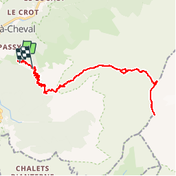
19.8 km | 37 km-effort
5h 9min
Yes
Trail Walking Sixt-Fer-à-Cheval - Sixt Fer à Cheval et cascades - Photo
Walking
tracegps

Walking

Medium
(3)
Sixt-Fer-à-Cheval, Auvergne-Rhône-Alpes, Upper Savoy, France
9.3 km | 14.1 km-effort
3h 0min
Yes
Trail Walking Samoëns - Samoens . gorges des tines - retour  - Photo
Walking
GUIDE
stef789

Walking

Very easy
Samoëns, Auvergne-Rhône-Alpes, Upper Savoy, France
9.6 km | 12.9 km-effort
4h 1min
Yes
Trail Walking Sixt-Fer-à-Cheval - Gorges des Tines - Gers - Samoens  - Photo
Walking
GUIDE
Kargil

Walking

Difficult
(1)
Sixt-Fer-à-Cheval, Auvergne-Rhône-Alpes, Upper Savoy, France
18.6 km | 33 km-effort
5h 52min
Yes
Trail Walking Sixt-Fer-à-Cheval - 2020-08-15 Marche Refuge Grenairon Le Mont Buet Les Fonts Salvagny - Photo
Walking
GUIDE
holtzv

Walking

Very easy
Sixt-Fer-à-Cheval, Auvergne-Rhône-Alpes, Upper Savoy, France
20 km | 40 km-effort
12h 24min
No
Trail Walking Passy - Le tour des Fiz : J2 - Photo
Walking
Greg813

Walking

Difficult
Passy, Auvergne-Rhône-Alpes, Upper Savoy, France
15.7 km | 31 km-effort
4h 41min
No
Trail Walking Sixt-Fer-à-Cheval - J9GR5Nord - Photo
Walking
annehc

Walking

Very difficult
Sixt-Fer-à-Cheval, Auvergne-Rhône-Alpes, Upper Savoy, France
16.8 km | 29 km-effort
6h 36min
No
Trail Walking Sixt-Fer-à-Cheval - SIXT PASSY RESERVE: CHALETS DE SALES 2 - Photo
Walking
djeepee74

Walking

Medium
Sixt-Fer-à-Cheval, Auvergne-Rhône-Alpes, Upper Savoy, France
11.5 km | 21 km-effort
4h 50min
Yes
Trail Walking Samoëns - les chalets du Bémont et cascade du Nant d Ant - Photo
Walking
José800

Walking

Medium
Samoëns, Auvergne-Rhône-Alpes, Upper Savoy, France
6.7 km | 10.5 km-effort
2h 10min
No


Close
My subscriptions