![](/images/other/stat-length.png)
![Trail Running Vernier - YHH028 Vernier (bord du Rhône) - Photo](https://media.geolcdn.com/t/1900/400/ext.pjpeg?maxdim=2&url=https%3A%2F%2Fstatic1.geolcdn.com%2Fsiteimages%2Fupload%2Ffiles%2F1524743154running.jpg)
YHH028 Vernier (bord du Rhône)
yveshumbert
User
![Length](/images/other/stat-length.png)
Length
10 km
![Max alt](https://static1.geolcdn.com/siteimages/upload/files/1508320355ic_sort_altitude_max_24dp.png)
Max alt
439 m
![Uphill gradient](https://static1.geolcdn.com/siteimages/upload/files/1508320355ic_sort_den_pos_24dp.png)
Uphill gradient
204 m
![Km-Effort](/images/other/stat-length.png)
Km-Effort
12.7 km
![Min alt](https://static1.geolcdn.com/siteimages/upload/files/1508320355ic_sort_altitude_min_24dp.png)
Min alt
368 m
![Downhill gradient](https://static1.geolcdn.com/siteimages/upload/files/1508320355ic_sort_den_neg_24dp.png)
Downhill gradient
205 m
![Boucle](https://static1.geolcdn.com/siteimages/upload/files/16400158638029165_repeat_loop_refresh_sync_direction_icon.png)
Boucle
Yes
Creation date :
2015-08-21 00:00:00.0
Updated on :
2015-08-21 00:00:00.0
![Running](https://static1.geolcdn.com/sitytour/trail-icons/103.png)
1h00
Difficulty : Medium
![Scan this QR Code to open this trail in the SityTrail application](https://capi.geolives.com/qq0zvz2zws4bq2lad0pu/sitytour/trails/462099/qr.png?size=200)
FREE GPS app for hiking
About
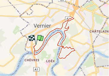
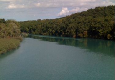
Trail Running of 10 km to be discovered at Geneva, Unknown, Vernier. This trail is proposed by yveshumbert.
Description
Jolie ballade à pied le long du Rhône,qui peut aussi se faire en jogging.Si vous trouvez le trajet trop long, vous pouvez couper à deux endroits, au niveau du lieu dit "le moulin" et/ou en prenant la passerelle sans faire le tour dans la Lignon
Positioning
Country:
Switzerland
Region :
Geneva
Department/Province :
Unknown
Municipality :
Vernier
Location:
Unknown
Start:(Dec)
Start:(UTM)
274606 ; 5121056 (32T) N.
Comments
Trails nearby
![Trail On foot Carouge (GE) - De Staël - Place Verte - Photo](https://media.geolcdn.com/t/375/260/097d8cc8-85e9-4d02-9d1d-72c864b74792.jpeg&format=jpg&maxdim=2)
![On foot On foot](https://static1.geolcdn.com/sitytour/trail-icons/100.png)
De Staël - Place Verte
On foot
Easy
Carouge (GE),
Geneva,
Unknown,
Switzerland
![](/images/other/stat-length.png)
3.3 km | 3.8 km-effort
51min
![](https://static1.geolcdn.com/siteimages/upload/files/16400158638029165_repeat_loop_refresh_sync_direction_icon.png)
No
![Trail Walking Bernex - Helsana Trail Rhone - Photo](https://media.geolcdn.com/t/375/260/ext.jpg?maxdim=2&url=https%3A%2F%2Fstatic1.geolcdn.com%2Fsiteimages%2Fupload%2Ffiles%2F1553511878bg_sport_marche.png)
![Walking Walking](https://static1.geolcdn.com/sitytour/trail-icons/101.png)
Helsana Trail Rhone
Walking
Very easy
(1)
Bernex,
Geneva,
Unknown,
Switzerland
![](/images/other/stat-length.png)
6.6 km | 8 km-effort
2h 1min
![](https://static1.geolcdn.com/siteimages/upload/files/16400158638029165_repeat_loop_refresh_sync_direction_icon.png)
No
![Trail Cycle Geneva - Via Rhôna - Genève - Pont St Esprit - Photo](https://media.geolcdn.com/t/375/260/ext.jpg?maxdim=2&url=https%3A%2F%2Fservices.sitytrail.com%2FGeolivesWS%2FDownloadMedia.ashx%3FTrailID%3D317976%26Media%3D17420_2.jpg)
![Cycle Cycle](https://static1.geolcdn.com/sitytour/trail-icons/200.png)
Via Rhôna - Genève - Pont St Esprit
Cycle
Difficult
Geneva,
Geneva,
Unknown,
Switzerland
![](/images/other/stat-length.png)
463 km | 518 km-effort
42h 0min
![](https://static1.geolcdn.com/siteimages/upload/files/16400158638029165_repeat_loop_refresh_sync_direction_icon.png)
No
![Trail Mountain bike Geneva - Via Rhôna - Genève - Pont St Esprit - Photo](https://media.geolcdn.com/t/375/260/ext.jpg?maxdim=2&url=https%3A%2F%2Fservices.sitytrail.com%2FGeolivesWS%2FDownloadMedia.ashx%3FTrailID%3D317975%26Media%3D17420_3.jpg)
![Mountain bike Mountain bike](https://static1.geolcdn.com/sitytour/trail-icons/202.png)
Via Rhôna - Genève - Pont St Esprit
Mountain bike
Difficult
Geneva,
Geneva,
Unknown,
Switzerland
![](/images/other/stat-length.png)
463 km | 518 km-effort
42h 0min
![](https://static1.geolcdn.com/siteimages/upload/files/16400158638029165_repeat_loop_refresh_sync_direction_icon.png)
No
![Trail Other activity Meyrin - geneve lille - Photo](https://media.geolcdn.com/t/375/260/ext.jpg?maxdim=2&url=https%3A%2F%2Fservices.sitytrail.com%2FGeolivesWS%2FDownloadMedia.ashx%3FTrailID%3D224518%26Media%3Dfix__20130930114226.jpg)
![Other activity Other activity](https://static1.geolcdn.com/sitytour/trail-icons/900.png)
geneve lille
Other activity
Very easy
(1)
Meyrin,
Geneva,
Unknown,
Switzerland
![](/images/other/stat-length.png)
615 km | 794 km-effort
1h 1min
![](https://static1.geolcdn.com/siteimages/upload/files/16400158638029165_repeat_loop_refresh_sync_direction_icon.png)
No
![Trail Other activity Meyrin - geneve lille - Photo](https://media.geolcdn.com/t/375/260/ext.jpg?maxdim=2&url=https%3A%2F%2Fservices.sitytrail.com%2FGeolivesWS%2FDownloadMedia.ashx%3FTrailID%3D224516%26Media%3Dfix__20130930114226.jpg)
![Other activity Other activity](https://static1.geolcdn.com/sitytour/trail-icons/900.png)
geneve lille
Other activity
Very easy
Meyrin,
Geneva,
Unknown,
Switzerland
![](/images/other/stat-length.png)
615 km | 794 km-effort
1h 1min
![](https://static1.geolcdn.com/siteimages/upload/files/16400158638029165_repeat_loop_refresh_sync_direction_icon.png)
No
![Trail Cycle Meyrin - 2012-04-21 11h33m19 - Photo](https://media.geolcdn.com/t/375/260/ext.jpg?maxdim=2&url=https%3A%2F%2Fstatic1.geolcdn.com%2Fsiteimages%2Fupload%2Ffiles%2F1524743154velo.jpg)
![Cycle Cycle](https://static1.geolcdn.com/sitytour/trail-icons/200.png)
2012-04-21 11h33m19
Cycle
Medium
(1)
Meyrin,
Geneva,
Unknown,
Switzerland
![](/images/other/stat-length.png)
33 km | 39 km-effort
1h 27min
![](https://static1.geolcdn.com/siteimages/upload/files/16400158638029165_repeat_loop_refresh_sync_direction_icon.png)
Yes
![Trail Walking Vernier - bord du Rhône lignon - Photo](https://media.geolcdn.com/t/375/260/ext.jpg?maxdim=2&url=https%3A%2F%2Fservices.sitytrail.com%2FGeolivesWS%2FDownloadMedia.ashx%3FTrailID%3D45700%26Media%3Dimage5.jpg)
![Walking Walking](https://static1.geolcdn.com/sitytour/trail-icons/101.png)
bord du Rhône lignon
Walking
Very easy
(1)
Vernier,
Geneva,
Unknown,
Switzerland
![](/images/other/stat-length.png)
6.1 km | 7.9 km-effort
Unknown
![](https://static1.geolcdn.com/siteimages/upload/files/16400158638029165_repeat_loop_refresh_sync_direction_icon.png)
Yes
![Trail Other activity Le Grand-Saconnex - bdr19_dGVA_Heremence - Photo](https://media.geolcdn.com/t/375/260/ext.jpg?maxdim=2&url=https%3A%2F%2Fstatic1.geolcdn.com%2Fsiteimages%2Fupload%2Ffiles%2F1545311037marcheuse_200dpi.jpg)
![Other activity Other activity](https://static1.geolcdn.com/sitytour/trail-icons/900.png)
bdr19_dGVA_Heremence
Other activity
Very easy
Le Grand-Saconnex,
Geneva,
Unknown,
Switzerland
![](/images/other/stat-length.png)
89 km | 104 km-effort
23h 30min
![](https://static1.geolcdn.com/siteimages/upload/files/16400158638029165_repeat_loop_refresh_sync_direction_icon.png)
No