![](/images/other/stat-length.png)
![Trail Snowshoes Val de Bagnes - Champsec, Sentier Raquettes n° 5, Champsec - Le Rosay - Photo](https://media.geolcdn.com/t/1900/400/ext.pjpeg?maxdim=2&url=https%3A%2F%2Fstatic1.geolcdn.com%2Fsiteimages%2Fupload%2Ffiles%2F1524743153raquette.jpg)
Champsec, Sentier Raquettes n° 5, Champsec - Le Rosay
verbier
User
![Length](/images/other/stat-length.png)
![Max alt](https://static1.geolcdn.com/siteimages/upload/files/1508320355ic_sort_altitude_max_24dp.png)
![Uphill gradient](https://static1.geolcdn.com/siteimages/upload/files/1508320355ic_sort_den_pos_24dp.png)
![Km-Effort](/images/other/stat-length.png)
![Min alt](https://static1.geolcdn.com/siteimages/upload/files/1508320355ic_sort_altitude_min_24dp.png)
![Downhill gradient](https://static1.geolcdn.com/siteimages/upload/files/1508320355ic_sort_den_neg_24dp.png)
![Boucle](https://static1.geolcdn.com/siteimages/upload/files/16400158638029165_repeat_loop_refresh_sync_direction_icon.png)
![Snowshoes](https://static1.geolcdn.com/sitytour/trail-icons/504.png)
2h00
Difficulty : Unknown
![Scan this QR Code to open this trail in the SityTrail application](https://capi.geolives.com/qq0zvz2zws4bq2lad0pu/sitytour/trails/46088/qr.png?size=200)
FREE GPS app for hiking
About
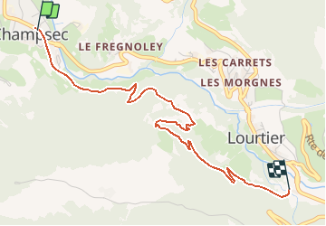
Trail Snowshoes of 3.8 km to be discovered at Valais/Wallis, Entremont, Val de Bagnes. This trail is proposed by verbier.
Description
Départ du village de Champsec (906 m) direction camping de la Sasse (929 m). Suivre le chemin pédestre jusqu’au lieu-dit La Tinte (1''150 m) puis deux variantes possibles :
1. traverser le pont de la Dranse direction Le Rosay (1''071 m) jusqu’à Lourtier (1''087 m)
2. suivre les balises jusqu’à la Gare des Glariers (1''094 m).
Positioning
Comments
Trails nearby
![Trail On foot Liddes - Chemins pédestre de montagne, région Orsières - Photo](https://media.geolcdn.com/t/375/260/8db834a7-d9d6-41f8-95ac-2756844d7a1f.jpeg&format=jpg&maxdim=2)
![On foot On foot](https://static1.geolcdn.com/sitytour/trail-icons/100.png)
On foot
![](/images/other/stat-length.png)
![](https://static1.geolcdn.com/siteimages/upload/files/16400158638029165_repeat_loop_refresh_sync_direction_icon.png)
![Trail On foot Val de Bagnes - Ancien Bisse du Levron - Photo](https://media.geolcdn.com/t/375/260/80610014-2440-48cc-bb45-b16896750006.jpeg&format=jpg&maxdim=2)
![On foot On foot](https://static1.geolcdn.com/sitytour/trail-icons/100.png)
On foot
![](/images/other/stat-length.png)
![](https://static1.geolcdn.com/siteimages/upload/files/16400158638029165_repeat_loop_refresh_sync_direction_icon.png)
![Trail On foot Val de Bagnes - Fionnay-Bonatchiesse - Photo](https://media.geolcdn.com/t/375/260/722b9f42-8e6c-40c8-97d5-9a76a6e7f852.jpeg&format=jpg&maxdim=2)
![On foot On foot](https://static1.geolcdn.com/sitytour/trail-icons/100.png)
On foot
![](/images/other/stat-length.png)
![](https://static1.geolcdn.com/siteimages/upload/files/16400158638029165_repeat_loop_refresh_sync_direction_icon.png)
![Trail On foot Val de Bagnes - Louvie-Fionnay - Photo](https://media.geolcdn.com/t/375/260/5fd2d0df-c707-4ac6-b9ec-327205fb196f.jpeg&format=jpg&maxdim=2)
![On foot On foot](https://static1.geolcdn.com/sitytour/trail-icons/100.png)
On foot
![](/images/other/stat-length.png)
![](https://static1.geolcdn.com/siteimages/upload/files/16400158638029165_repeat_loop_refresh_sync_direction_icon.png)
![Trail On foot Val de Bagnes - Col Termin-Louvie - Photo](https://media.geolcdn.com/t/375/260/5fd2d0df-c707-4ac6-b9ec-327205fb196f.jpeg&format=jpg&maxdim=2)
![On foot On foot](https://static1.geolcdn.com/sitytour/trail-icons/100.png)
On foot
![](/images/other/stat-length.png)
![](https://static1.geolcdn.com/siteimages/upload/files/16400158638029165_repeat_loop_refresh_sync_direction_icon.png)
![Trail Walking Val de Bagnes - La Haute Route : J2 - Photo](https://media.geolcdn.com/t/375/260/180b2b28-d72b-4e1f-bcdd-fa58e937cbf2.jpg&format=jpg&maxdim=2)
![Walking Walking](https://static1.geolcdn.com/sitytour/trail-icons/101.png)
Walking
![](/images/other/stat-length.png)
![](https://static1.geolcdn.com/siteimages/upload/files/16400158638029165_repeat_loop_refresh_sync_direction_icon.png)
![Trail On foot Val de Bagnes - Promenade de la Dranse - Photo](https://media.geolcdn.com/t/375/260/086adfed-46f4-4991-8417-75cd394f8ae1.jpeg&format=jpg&maxdim=2)
![On foot On foot](https://static1.geolcdn.com/sitytour/trail-icons/100.png)
On foot
![](/images/other/stat-length.png)
![](https://static1.geolcdn.com/siteimages/upload/files/16400158638029165_repeat_loop_refresh_sync_direction_icon.png)
![Trail On foot Val de Bagnes - Chemins pédestres, région Bagnes - Photo](https://media.geolcdn.com/t/375/260/8db834a7-d9d6-41f8-95ac-2756844d7a1f.jpeg&format=jpg&maxdim=2)
![On foot On foot](https://static1.geolcdn.com/sitytour/trail-icons/100.png)
On foot
![](/images/other/stat-length.png)
![](https://static1.geolcdn.com/siteimages/upload/files/16400158638029165_repeat_loop_refresh_sync_direction_icon.png)
![Trail On foot Val de Bagnes - Bruson - Moay - Photo](https://media.geolcdn.com/t/375/260/086adfed-46f4-4991-8417-75cd394f8ae1.jpeg&format=jpg&maxdim=2)
![On foot On foot](https://static1.geolcdn.com/sitytour/trail-icons/100.png)
On foot
![](/images/other/stat-length.png)
![](https://static1.geolcdn.com/siteimages/upload/files/16400158638029165_repeat_loop_refresh_sync_direction_icon.png)