


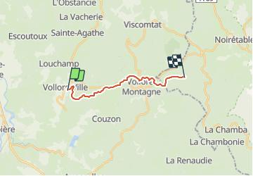

9.7 km | 12.8 km-effort


User


FREE GPS app for hiking
 SityTrail
IGN / Geographical institutes
SityTrail World
The world is yours!
Trail Walking of 13 km to be discovered at Auvergne-Rhône-Alpes, Puy-de-Dôme, Vollore-Ville. This trail is proposed by pierreroze.
vollore ville à l'hermitage

Walking

Walking

Walking
On foot

On foot

On foot

Walking
Walking

sport