![](/images/other/stat-length.png)
![Trail Walking Châtel-Saint-Germain - Promenade de la perdrix - Photo](https://media.geolcdn.com/t/1900/400/ext.pjpeg?maxdim=2&url=https%3A%2F%2Fstatic1.geolcdn.com%2Fsiteimages%2Fupload%2Ffiles%2F1553511878bg_sport_marche.png)
Promenade de la perdrix
ticaillou
User
![Length](/images/other/stat-length.png)
![Max alt](https://static1.geolcdn.com/siteimages/upload/files/1508320355ic_sort_altitude_max_24dp.png)
![Uphill gradient](https://static1.geolcdn.com/siteimages/upload/files/1508320355ic_sort_den_pos_24dp.png)
![Km-Effort](/images/other/stat-length.png)
![Min alt](https://static1.geolcdn.com/siteimages/upload/files/1508320355ic_sort_altitude_min_24dp.png)
![Downhill gradient](https://static1.geolcdn.com/siteimages/upload/files/1508320355ic_sort_den_neg_24dp.png)
![Boucle](https://static1.geolcdn.com/siteimages/upload/files/16400158638029165_repeat_loop_refresh_sync_direction_icon.png)
![Signpost](https://services.sitytrail.com/GeolivesWS/DownloadMedia.ashx?TrailID=457899&Media=balise.png)
![Walking](https://static1.geolcdn.com/sitytour/trail-icons/101.png)
2h00
Difficulty : Easy
![Scan this QR Code to open this trail in the SityTrail application](https://capi.geolives.com/qq0zvz2zws4bq2lad0pu/sitytour/trails/457899/qr.png?size=200)
FREE GPS app for hiking
About
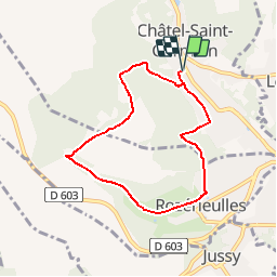
Trail Walking of 6.4 km to be discovered at Grand Est, Moselle, Châtel-Saint-Germain. This trail is proposed by ticaillou.
Description
A partir de la place du lavoir suivre le rue de Cléry sur la gauche, puis la rue des Chauvaux jusqu'aux écoles. Monter la rue du Rébénot, puis le chemin des Goules jusqu'à la route de guerre. Sur la gauche reprendre tout de suite à droite (env. 20m) un diverticule de la route de guerre. Monter jusqu'à l'ancienne voie romaine. Prendre à gauche vers Rozérieulles jusqu'aux courts de tennis. Les contourner par la gauche et poursuivre à droite vers la rue du fort Jeanne d'Arc. Continuer tout droit sur la route de Paris jusqu'à l'entrée du fort. Tourner à droite en direction du moto cross et prendre gauche le chemin de contournement du fort. Continuer tout droit vers le bois du reposoir. Traverser la route de guerre et descendre par le chemin de Gravelotte. Prendre à droite le chemin du reposoir jusqu'à la rue de Cléry.
Positioning
Comments
Trails nearby
![Trail Walking Plappeville - Saint Quentin - Photo](https://media.geolcdn.com/t/375/260/ext.jpg?maxdim=2&url=https%3A%2F%2Fservices.sitytrail.com%2FGeolivesWS%2FDownloadMedia.ashx%3FTrailID%3D159776%26Media%3D20121024120133.jpg)
![Walking Walking](https://static1.geolcdn.com/sitytour/trail-icons/101.png)
Walking
![](/images/other/stat-length.png)
![](https://static1.geolcdn.com/siteimages/upload/files/16400158638029165_repeat_loop_refresh_sync_direction_icon.png)
![Trail Walking Châtel-Saint-Germain - Châtel-Saint-Germain - Photo](https://media.geolcdn.com/t/375/260/ext.jpg?maxdim=2&url=https%3A%2F%2Fservices.sitytrail.com%2FGeolivesWS%2FDownloadMedia.ashx%3FTrailID%3D150891%26Media%3D20120830125222.jpg)
![Walking Walking](https://static1.geolcdn.com/sitytour/trail-icons/101.png)
Walking
![](/images/other/stat-length.png)
![](https://static1.geolcdn.com/siteimages/upload/files/16400158638029165_repeat_loop_refresh_sync_direction_icon.png)
![Trail Walking Plappeville - Autour du fort de Plappeville. - Photo](https://media.geolcdn.com/t/375/260/ext.jpg?maxdim=2&url=https%3A%2F%2Fservices.sitytrail.com%2FGeolivesWS%2FDownloadMedia.ashx%3FTrailID%3D147559%26Media%3D20120816102740.jpg)
![Walking Walking](https://static1.geolcdn.com/sitytour/trail-icons/101.png)
Walking
![](/images/other/stat-length.png)
![](https://static1.geolcdn.com/siteimages/upload/files/16400158638029165_repeat_loop_refresh_sync_direction_icon.png)
![Trail On foot Vaux - Circuit de la Vallée de la Mance - Photo](https://media.geolcdn.com/t/375/260/981790cb-52ff-420b-b1f6-a906426f0c54.jpeg&format=jpg&maxdim=2)
![On foot On foot](https://static1.geolcdn.com/sitytour/trail-icons/100.png)
On foot
![](/images/other/stat-length.png)
![](https://static1.geolcdn.com/siteimages/upload/files/16400158638029165_repeat_loop_refresh_sync_direction_icon.png)
![Trail On foot Lessy - Circuit de Plappeville - Photo](https://media.geolcdn.com/t/375/260/7273a269-0c57-4318-8c49-dbed329cb79a.jpeg&format=jpg&maxdim=2)
![On foot On foot](https://static1.geolcdn.com/sitytour/trail-icons/100.png)
On foot
![](/images/other/stat-length.png)
![](https://static1.geolcdn.com/siteimages/upload/files/16400158638029165_repeat_loop_refresh_sync_direction_icon.png)
![Trail On foot Scy-Chazelles - Circuit Robert Schuman - Photo](https://media.geolcdn.com/t/375/260/7afac14e-8e32-42d2-8dfe-26d9e6a8df51.jpeg&format=jpg&maxdim=2)
![On foot On foot](https://static1.geolcdn.com/sitytour/trail-icons/100.png)
On foot
![](/images/other/stat-length.png)
![](https://static1.geolcdn.com/siteimages/upload/files/16400158638029165_repeat_loop_refresh_sync_direction_icon.png)
![Trail On foot Scy-Chazelles - Circuit du Tour du Mont St Quentin - Photo](https://media.geolcdn.com/t/375/260/0227a6bb-ecc7-41f2-b92a-b603e3858c5b.jpeg&format=jpg&maxdim=2)
![On foot On foot](https://static1.geolcdn.com/sitytour/trail-icons/100.png)
On foot
![](/images/other/stat-length.png)
![](https://static1.geolcdn.com/siteimages/upload/files/16400158638029165_repeat_loop_refresh_sync_direction_icon.png)
![Trail Walking Saulny - plesnois - Photo](https://media.geolcdn.com/t/375/260/30dd64af-04ad-4ba2-adb2-9542b50b478b.jpg&format=jpg&maxdim=2)
![Walking Walking](https://static1.geolcdn.com/sitytour/trail-icons/101.png)
![Trail Walking Saulny - Saulny 8 mai 2013 14 km - Photo](https://media.geolcdn.com/t/375/260/ext.jpg?maxdim=2&url=https%3A%2F%2Fstatic1.geolcdn.com%2Fsiteimages%2Fupload%2Ffiles%2F1553511878bg_sport_marche.png)
![Walking Walking](https://static1.geolcdn.com/sitytour/trail-icons/101.png)
Walking
![](/images/other/stat-length.png)
![](https://static1.geolcdn.com/siteimages/upload/files/16400158638029165_repeat_loop_refresh_sync_direction_icon.png)