![](/images/other/stat-length.png)
![Trail Walking Montarcher - Montarcher circuit des Croix - Photo](https://media.geolcdn.com/t/1900/400/ext.pjpeg?maxdim=2&url=https%3A%2F%2Fservices.sitytrail.com%2FGeolivesWS%2FDownloadMedia.ashx%3FTrailID%3D455587%26Media%3D20150807120337.jpg)
Montarcher circuit des Croix
GPit42
User
![Length](/images/other/stat-length.png)
Length
12.8 km
![Max alt](https://static1.geolcdn.com/siteimages/upload/files/1508320355ic_sort_altitude_max_24dp.png)
Max alt
1145 m
![Uphill gradient](https://static1.geolcdn.com/siteimages/upload/files/1508320355ic_sort_den_pos_24dp.png)
Uphill gradient
382 m
![Km-Effort](/images/other/stat-length.png)
Km-Effort
17.9 km
![Min alt](https://static1.geolcdn.com/siteimages/upload/files/1508320355ic_sort_altitude_min_24dp.png)
Min alt
961 m
![Downhill gradient](https://static1.geolcdn.com/siteimages/upload/files/1508320355ic_sort_den_neg_24dp.png)
Downhill gradient
378 m
![Boucle](https://static1.geolcdn.com/siteimages/upload/files/16400158638029165_repeat_loop_refresh_sync_direction_icon.png)
Boucle
Yes
Creation date :
2015-08-07 00:00:00.0
Updated on :
2015-08-07 00:00:00.0
![Walking](https://static1.geolcdn.com/sitytour/trail-icons/101.png)
3h46
Difficulty : Very easy
![Scan this QR Code to open this trail in the SityTrail application](https://capi.geolives.com/qq0zvz2zws4bq2lad0pu/sitytour/trails/455587/qr.png?size=200)
FREE GPS app for hiking
About
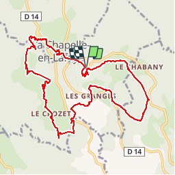
Trail Walking of 12.8 km to be discovered at Auvergne-Rhône-Alpes, Loire, Montarcher. This trail is proposed by GPit42.
Description
Balade n°22 tirée du topo guide PR la Loire à pied
indiquée 9 kms - un autre GPS nous affiche 10,72 kms alors que celui-ci 12,8 kms qui nous semble surévalué
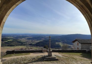
très beau circuit qui porte bien son nom
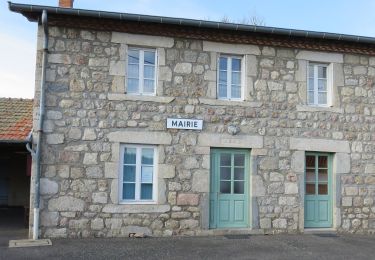
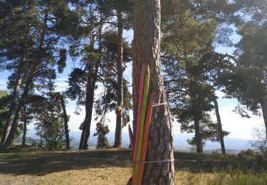
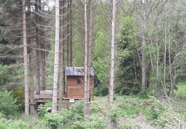
Positioning
Country:
France
Region :
Auvergne-Rhône-Alpes
Department/Province :
Loire
Municipality :
Montarcher
Location:
Unknown
Start:(Dec)
Start:(UTM)
577836 ; 5034495 (31T) N.
Comments
Trails nearby
![Trail On foot Montarcher - Montarcher - Photo](https://media.geolcdn.com/t/375/260/3ba12c50-f9c1-4680-a510-ed795cb76957.jpeg&format=jpg&maxdim=2)
![On foot On foot](https://static1.geolcdn.com/sitytour/trail-icons/100.png)
Montarcher
On foot
Easy
Montarcher,
Auvergne-Rhône-Alpes,
Loire,
France
![](/images/other/stat-length.png)
13.2 km | 18.1 km-effort
4h 6min
![](https://static1.geolcdn.com/siteimages/upload/files/16400158638029165_repeat_loop_refresh_sync_direction_icon.png)
Yes
![Trail Walking Montarcher - le circuit des brigands - Photo](https://media.geolcdn.com/t/375/260/7e2918f3-c381-4b30-9846-01d4675035ef.jpg&format=jpg&maxdim=2)
![Walking Walking](https://static1.geolcdn.com/sitytour/trail-icons/101.png)
le circuit des brigands
Walking
Easy
Montarcher,
Auvergne-Rhône-Alpes,
Loire,
France
![](/images/other/stat-length.png)
13.8 km | 0 m-effort
3h 30min
![](https://static1.geolcdn.com/siteimages/upload/files/16400158638029165_repeat_loop_refresh_sync_direction_icon.png)
Yes
![Trail Walking Montarcher - tour de Montarcher - Photo](https://media.geolcdn.com/t/375/260/172ac877-0307-4162-be24-d60bf4a6e862.jpg&format=jpg&maxdim=2)
![Walking Walking](https://static1.geolcdn.com/sitytour/trail-icons/101.png)
tour de Montarcher
Walking
Very easy
Montarcher,
Auvergne-Rhône-Alpes,
Loire,
France
![](/images/other/stat-length.png)
599 m | 665 m-effort
25min
![](https://static1.geolcdn.com/siteimages/upload/files/16400158638029165_repeat_loop_refresh_sync_direction_icon.png)
Yes
![Trail Walking Montarcher - montarcher - Photo](https://media.geolcdn.com/t/375/260/ext.jpg?maxdim=2&url=https%3A%2F%2Fstatic1.geolcdn.com%2Fsiteimages%2Fupload%2Ffiles%2F1553511878bg_sport_marche.png)
![Walking Walking](https://static1.geolcdn.com/sitytour/trail-icons/101.png)
montarcher
Walking
Very easy
Montarcher,
Auvergne-Rhône-Alpes,
Loire,
France
![](/images/other/stat-length.png)
5.7 km | 6.8 km-effort
1h 51min
![](https://static1.geolcdn.com/siteimages/upload/files/16400158638029165_repeat_loop_refresh_sync_direction_icon.png)
Yes
![Trail Walking La Chapelle-en-Lafaye - la Chaulme Crozet Chaussettes 895 - Photo](https://media.geolcdn.com/t/375/260/2fbfa6af-8623-425a-8c47-6eafbd828ff9.jpg&format=jpg&maxdim=2)
![Walking Walking](https://static1.geolcdn.com/sitytour/trail-icons/101.png)
la Chaulme Crozet Chaussettes 895
Walking
Easy
La Chapelle-en-Lafaye,
Auvergne-Rhône-Alpes,
Loire,
France
![](/images/other/stat-length.png)
3.6 km | 4.8 km-effort
1h 27min
![](https://static1.geolcdn.com/siteimages/upload/files/16400158638029165_repeat_loop_refresh_sync_direction_icon.png)
Yes
![Trail Walking Marols - J6-Chossy - Jouenzec - Photo](https://media.geolcdn.com/t/375/260/ext.jpg?maxdim=2&url=https%3A%2F%2Fstatic1.geolcdn.com%2Fsiteimages%2Fupload%2Ffiles%2F1553511878bg_sport_marche.png)
![Walking Walking](https://static1.geolcdn.com/sitytour/trail-icons/101.png)
J6-Chossy - Jouenzec
Walking
Medium
Marols,
Auvergne-Rhône-Alpes,
Loire,
France
![](/images/other/stat-length.png)
22 km | 29 km-effort
5h 4min
![](https://static1.geolcdn.com/siteimages/upload/files/16400158638029165_repeat_loop_refresh_sync_direction_icon.png)
No
![Trail Walking Marols - J6 - Photo](https://media.geolcdn.com/t/375/260/ext.jpg?maxdim=2&url=https%3A%2F%2Fstatic1.geolcdn.com%2Fsiteimages%2Fupload%2Ffiles%2F1553511878bg_sport_marche.png)
![Walking Walking](https://static1.geolcdn.com/sitytour/trail-icons/101.png)
J6
Walking
Very difficult
Marols,
Auvergne-Rhône-Alpes,
Loire,
France
![](/images/other/stat-length.png)
22 km | 29 km-effort
5h 13min
![](https://static1.geolcdn.com/siteimages/upload/files/16400158638029165_repeat_loop_refresh_sync_direction_icon.png)
No
![Trail Walking Saint-Jean-Soleymieux - la courte - Photo](https://media.geolcdn.com/t/375/260/ext.jpg?maxdim=2&url=https%3A%2F%2Fstatic1.geolcdn.com%2Fsiteimages%2Fupload%2Ffiles%2F1553511878bg_sport_marche.png)
![Walking Walking](https://static1.geolcdn.com/sitytour/trail-icons/101.png)
la courte
Walking
Very easy
Saint-Jean-Soleymieux,
Auvergne-Rhône-Alpes,
Loire,
France
![](/images/other/stat-length.png)
4.4 km | 6.2 km-effort
57min
![](https://static1.geolcdn.com/siteimages/upload/files/16400158638029165_repeat_loop_refresh_sync_direction_icon.png)
Yes
![Trail Walking Saint-Jean-Soleymieux - sentier des babets - Photo](https://media.geolcdn.com/t/375/260/ext.jpg?maxdim=2&url=https%3A%2F%2Fstatic1.geolcdn.com%2Fsiteimages%2Fupload%2Ffiles%2F1553511878bg_sport_marche.png)
![Walking Walking](https://static1.geolcdn.com/sitytour/trail-icons/101.png)
sentier des babets
Walking
Easy
Saint-Jean-Soleymieux,
Auvergne-Rhône-Alpes,
Loire,
France
![](/images/other/stat-length.png)
7.5 km | 10.1 km-effort
1h 49min
![](https://static1.geolcdn.com/siteimages/upload/files/16400158638029165_repeat_loop_refresh_sync_direction_icon.png)
Yes
super joli parcours..