![](/images/other/stat-length.png)
![Trail Walking Chaudeyrolles - Ardeche - Mézenc - Le tour du Mézenc 17km D+557m - Photo](https://media.geolcdn.com/t/1900/400/ext.pjpeg?maxdim=2&url=https%3A%2F%2Fstatic1.geolcdn.com%2Fsiteimages%2Fupload%2Ffiles%2F1553511878bg_sport_marche.png)
Ardeche - Mézenc - Le tour du Mézenc 17km D+557m
manumax
User
![Length](/images/other/stat-length.png)
![Max alt](https://static1.geolcdn.com/siteimages/upload/files/1508320355ic_sort_altitude_max_24dp.png)
![Uphill gradient](https://static1.geolcdn.com/siteimages/upload/files/1508320355ic_sort_den_pos_24dp.png)
![Km-Effort](/images/other/stat-length.png)
![Min alt](https://static1.geolcdn.com/siteimages/upload/files/1508320355ic_sort_altitude_min_24dp.png)
![Downhill gradient](https://static1.geolcdn.com/siteimages/upload/files/1508320355ic_sort_den_neg_24dp.png)
![Boucle](https://static1.geolcdn.com/siteimages/upload/files/16400158638029165_repeat_loop_refresh_sync_direction_icon.png)
![Walking](https://static1.geolcdn.com/sitytour/trail-icons/101.png)
6h30
Difficulty : Difficult
![Scan this QR Code to open this trail in the SityTrail application](https://capi.geolives.com/qq0zvz2zws4bq2lad0pu/sitytour/trails/454357/qr.png?size=200)
FREE GPS app for hiking
About
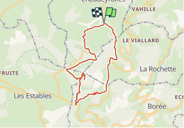
Trail Walking of 16.7 km to be discovered at Auvergne-Rhône-Alpes, Haute-Loire, Chaudeyrolles. This trail is proposed by manumax.
Description
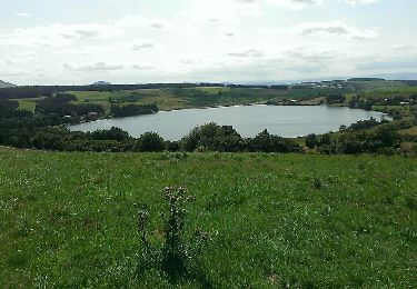
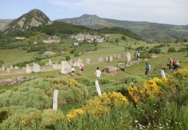
Randonnée à faire de préférence en Juillet pour la beauté des floraisons. Le mont Mézenc, d'origine volcanique, culmine à 1 754 m d'altitude. Il est situé sur la même ligne de crête que le mont Gerbier de Jonc, entre Velay et Vivarais dans le massif du Mézenc au sein du Massif central. Il est constitué de deux sommets distants d'un demi kilomètre. Le sommet Sud est le plus élevé à 1 754 mètres d'altitude, il est situé dans le département de l'Ardèche. Le sommet Nord est surmonté d'une croix et culmine pour sa part à 1 749 mètres d'altitude. Il s'agit du point culminant du département de la Haute-Loire. (source Wikipédia)
Positioning
Comments
Trails nearby
![Trail Walking Saint-Front - Tour du lac St Front - Photo](https://media.geolcdn.com/t/375/260/ext.jpg?maxdim=2&url=https%3A%2F%2Fservices.sitytrail.com%2FGeolivesWS%2FDownloadMedia.ashx%3FTrailID%3D331313%26Media%3Dfix__20140805155239.jpg)
![Walking Walking](https://static1.geolcdn.com/sitytour/trail-icons/101.png)
Walking
![](/images/other/stat-length.png)
![](https://static1.geolcdn.com/siteimages/upload/files/16400158638029165_repeat_loop_refresh_sync_direction_icon.png)
![Trail Mountain bike Les Estables - Site VTT FFC du Mézenc et de la Loire sauvage - Circuit n° 04 - Tour du Mont Alambre - Photo](https://media.geolcdn.com/t/375/260/ext.jpg?maxdim=2&url=https%3A%2F%2Fservices.sitytrail.com%2FGeolivesWS%2FDownloadMedia.ashx%3FTrailID%3D107489%26Media%3D12434_3.jpg)
![Mountain bike Mountain bike](https://static1.geolcdn.com/sitytour/trail-icons/202.png)
Mountain bike
![](/images/other/stat-length.png)
![](https://static1.geolcdn.com/siteimages/upload/files/16400158638029165_repeat_loop_refresh_sync_direction_icon.png)
![Trail Mountain bike Les Estables - Site VTT FFC du Mézenc et de la Loire sauvage - Circuit n° 07 - Boucle en foret domaniale - Photo](https://media.geolcdn.com/t/375/260/ext.jpg?maxdim=2&url=https%3A%2F%2Fservices.sitytrail.com%2FGeolivesWS%2FDownloadMedia.ashx%3FTrailID%3D107492%26Media%3D12437_2.jpg)
![Mountain bike Mountain bike](https://static1.geolcdn.com/sitytour/trail-icons/202.png)
Mountain bike
![](/images/other/stat-length.png)
![](https://static1.geolcdn.com/siteimages/upload/files/16400158638029165_repeat_loop_refresh_sync_direction_icon.png)
![Trail Walking Borée - Boree Mezenc Croix Boutieres 19km - Photo](https://media.geolcdn.com/t/375/260/cc287dcb-1e8d-4076-b943-e2b204dd23b4.jpg&format=jpg&maxdim=2)
![Walking Walking](https://static1.geolcdn.com/sitytour/trail-icons/101.png)
Walking
![](/images/other/stat-length.png)
![](https://static1.geolcdn.com/siteimages/upload/files/16400158638029165_repeat_loop_refresh_sync_direction_icon.png)
![Trail Walking Les Estables - Mont Mezenc - Photo](https://media.geolcdn.com/t/375/260/ce0fbf1f-346a-43be-bffd-dfd03dc61c12.jpg&format=jpg&maxdim=2)
![Walking Walking](https://static1.geolcdn.com/sitytour/trail-icons/101.png)
Walking
![](/images/other/stat-length.png)
![](https://static1.geolcdn.com/siteimages/upload/files/16400158638029165_repeat_loop_refresh_sync_direction_icon.png)
![Trail Cycle Saint-Clément - ST CLEMENT - Photo](https://media.geolcdn.com/t/375/260/ext.jpg?maxdim=2&url=https%3A%2F%2Fstatic1.geolcdn.com%2Fsiteimages%2Fupload%2Ffiles%2F1524743154velo.jpg)
![Cycle Cycle](https://static1.geolcdn.com/sitytour/trail-icons/200.png)
Cycle
![](/images/other/stat-length.png)
![](https://static1.geolcdn.com/siteimages/upload/files/16400158638029165_repeat_loop_refresh_sync_direction_icon.png)
![Trail Walking Borée - Le tour du Mont Mézenc en Ardèche - Photo](https://media.geolcdn.com/t/375/260/970aece0-8ccf-44ea-bc9f-1d6489c7e0aa.jpg&format=jpg&maxdim=2)
![Walking Walking](https://static1.geolcdn.com/sitytour/trail-icons/101.png)
Walking
![](/images/other/stat-length.png)
![](https://static1.geolcdn.com/siteimages/upload/files/16400158638029165_repeat_loop_refresh_sync_direction_icon.png)
![Trail Walking La Rochette - Le tour du Mont Signon au départ de la chambre d'hôtes La retrouvade - Photo](https://media.geolcdn.com/t/375/260/a743c4a1-06ad-43d0-8b82-bee213f09387.jpg&format=jpg&maxdim=2)
![Walking Walking](https://static1.geolcdn.com/sitytour/trail-icons/101.png)
Walking
![](/images/other/stat-length.png)
![](https://static1.geolcdn.com/siteimages/upload/files/16400158638029165_repeat_loop_refresh_sync_direction_icon.png)
![Trail Walking Les Estables - Mont Mezenc Tour et sommet - Photo](https://media.geolcdn.com/t/375/260/fadc45c1-ba83-4e9a-a452-756f5fd46c63.jpg&format=jpg&maxdim=2)
![Walking Walking](https://static1.geolcdn.com/sitytour/trail-icons/101.png)
Walking
![](/images/other/stat-length.png)
![](https://static1.geolcdn.com/siteimages/upload/files/16400158638029165_repeat_loop_refresh_sync_direction_icon.png)