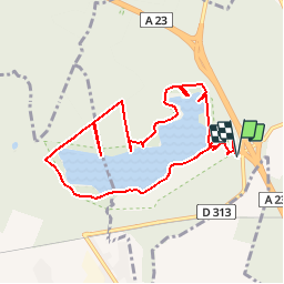
![](/images/other/stat-length.png)
Circuit de la Mare à Goriaux
corsinou
User
![Length](/images/other/stat-length.png)
![Max alt](https://static1.geolcdn.com/siteimages/upload/files/1508320355ic_sort_altitude_max_24dp.png)
![Uphill gradient](https://static1.geolcdn.com/siteimages/upload/files/1508320355ic_sort_den_pos_24dp.png)
![Km-Effort](/images/other/stat-length.png)
![Min alt](https://static1.geolcdn.com/siteimages/upload/files/1508320355ic_sort_altitude_min_24dp.png)
![Downhill gradient](https://static1.geolcdn.com/siteimages/upload/files/1508320355ic_sort_den_neg_24dp.png)
![Boucle](https://static1.geolcdn.com/siteimages/upload/files/16400158638029165_repeat_loop_refresh_sync_direction_icon.png)
![Walking](https://static1.geolcdn.com/sitytour/trail-icons/101.png)
2h09
Difficulty : Easy
![Scan this QR Code to open this trail in the SityTrail application](https://capi.geolives.com/qq0zvz2zws4bq2lad0pu/sitytour/trails/453764/qr.png?size=200)
FREE GPS app for hiking
About
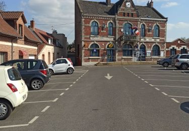
Trail Walking of 8.5 km to be discovered at Hauts-de-France, Nord, Raismes. This trail is proposed by corsinou.
Description
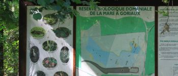
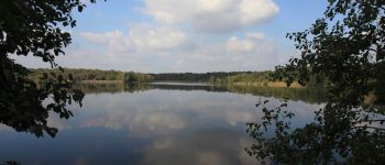
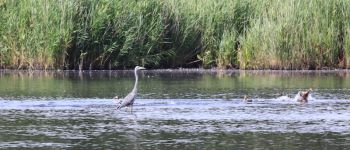
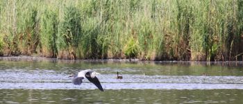
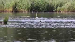
Randonnée autour de la réserve domaniale de la Mare à Goriaux.
L'affaissement de terrain de 1916 a créé trois mares : Bassy, Aubry et la mare à Goriaux. Ces trois mares ont fini par former en 1930 un seul plan d'eau, prenant le nom de mare à Goriaux (goriaux signifiant cochons en patois).
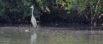
En 1968 une réserve ornithologique est créée à cause de la prolifération de l'avifaune.
En 1982 le site a été classé réserve biologique domaniale, pour l'intérêt de la recolonisation par la flore et la faune du terril de la mare à Goriaux.
Positioning
Comments
Trails nearby
![Trail Walking Raismes - Circuit du Terril de Sabatier - Photo](https://media.geolcdn.com/t/375/260/ext.jpg?maxdim=2&url=https%3A%2F%2Fservices.sitytrail.com%2FGeolivesWS%2FDownloadMedia.ashx%3FTrailID%3D479716%26Media%3D781031eb-7ab3-4c80-8a0c-0836d5a81ce2.JPG)
![Walking Walking](https://static1.geolcdn.com/sitytour/trail-icons/101.png)
Walking
![](/images/other/stat-length.png)
![](https://static1.geolcdn.com/siteimages/upload/files/16400158638029165_repeat_loop_refresh_sync_direction_icon.png)
![Trail Walking Wallers - Mare à Goriau - Photo](https://media.geolcdn.com/t/375/260/299e6191-18b5-438f-9d95-49f66a90f690.jpg&format=jpg&maxdim=2)
![Walking Walking](https://static1.geolcdn.com/sitytour/trail-icons/101.png)
Walking
![](/images/other/stat-length.png)
![](https://static1.geolcdn.com/siteimages/upload/files/16400158638029165_repeat_loop_refresh_sync_direction_icon.png)
![Trail Walking Raismes - Mare à Goriaux - Photo](https://media.geolcdn.com/t/375/260/cb4184f6-3666-47fb-a89a-0644abab2b32.jpg&format=jpg&maxdim=2)
![Walking Walking](https://static1.geolcdn.com/sitytour/trail-icons/101.png)
Walking
![](/images/other/stat-length.png)
![](https://static1.geolcdn.com/siteimages/upload/files/16400158638029165_repeat_loop_refresh_sync_direction_icon.png)
![Trail Walking Saint-Amand-les-Eaux - terril vicoigne - Photo](https://media.geolcdn.com/t/375/260/d8552856-5959-4bc8-a6d2-93f721ca17ec.jpg&format=jpg&maxdim=2)
![Walking Walking](https://static1.geolcdn.com/sitytour/trail-icons/101.png)
Walking
![](/images/other/stat-length.png)
![](https://static1.geolcdn.com/siteimages/upload/files/16400158638029165_repeat_loop_refresh_sync_direction_icon.png)
![Trail Walking Saint-Amand-les-Eaux - notre dame d'amour(NDA), propose par VDN - Photo](https://media.geolcdn.com/t/375/260/630cd120-0ef0-4a83-86e7-91e6331d9f35.jpg&format=jpg&maxdim=2)
![Walking Walking](https://static1.geolcdn.com/sitytour/trail-icons/101.png)
Walking
![](/images/other/stat-length.png)
![](https://static1.geolcdn.com/siteimages/upload/files/16400158638029165_repeat_loop_refresh_sync_direction_icon.png)
![Trail Walking Raismes - variante de la course des terrils - Photo](https://media.geolcdn.com/t/375/260/f1af6116-6469-445b-a358-4f5a4f22ced7.jpg&format=jpg&maxdim=2)
![Walking Walking](https://static1.geolcdn.com/sitytour/trail-icons/101.png)
Walking
![](/images/other/stat-length.png)
![](https://static1.geolcdn.com/siteimages/upload/files/16400158638029165_repeat_loop_refresh_sync_direction_icon.png)
![Trail Walking Wallers - Mare goraux - Photo](https://media.geolcdn.com/t/375/260/82eaa7c8-ae6a-4094-92a3-48d31e49731d.jpg&format=jpg&maxdim=2)
![Walking Walking](https://static1.geolcdn.com/sitytour/trail-icons/101.png)
Walking
![](/images/other/stat-length.png)
![](https://static1.geolcdn.com/siteimages/upload/files/16400158638029165_repeat_loop_refresh_sync_direction_icon.png)
![Trail Walking Haveluy - les pavés Bernard Hinault et pont femme à barbe - Photo](https://media.geolcdn.com/t/375/260/30f93038-ad16-4382-a628-c3d075d4266b.jpg&format=jpg&maxdim=2)
![Walking Walking](https://static1.geolcdn.com/sitytour/trail-icons/101.png)
Walking
![](/images/other/stat-length.png)
![](https://static1.geolcdn.com/siteimages/upload/files/16400158638029165_repeat_loop_refresh_sync_direction_icon.png)
![Trail Walking Wallers - tour d'Hasnon par forêt et ruisseau - Photo](https://media.geolcdn.com/t/375/260/2b9bf806-1bf3-4e60-9b73-d4a339f79ca9.jpg&format=jpg&maxdim=2)
![Walking Walking](https://static1.geolcdn.com/sitytour/trail-icons/101.png)
Walking
![](/images/other/stat-length.png)
![](https://static1.geolcdn.com/siteimages/upload/files/16400158638029165_repeat_loop_refresh_sync_direction_icon.png)