Trail Walking L'Argentière-la-Bessée - LES ECRINS - LE PAS DE LA CAVALE 22.5KM - Photo
 jpb83
jpb83

User

© OpenStreetMap contributors
Length
Length
22 km
Max alt
Max alt
2721 m
Uphill gradient
Uphill gradient
1226 m
Km-Effort
Km-Effort  
38 km
Min alt
Min alt
1567 m
Downhill gradient
Downhill gradient
1226 m
Boucle
Boucle
Yes
Creation date :
2015-08-02 00:00:00.0
Updated on :
2015-08-02 00:00:00.0

(0 Reviews)

Walking
Walking
7h49
Difficulty : Difficult

Scan this QR Code to open this trail in the SityTrail application

FREE GPS app for hiking

Logo SityTrail SityTrail

IGN / Geographical institutes

Download SityTrail from the App Store Download SityTrail from Google Play

Logo SityTrail SityTrail World

The world is yours!

Download SityTrail from the App Store Download SityTrail from Google Play Download SityTrail on Huawei AppGallery

About

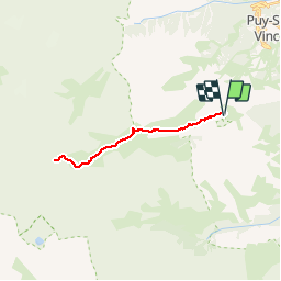
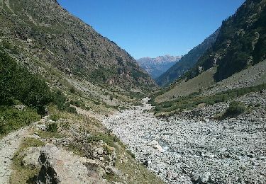
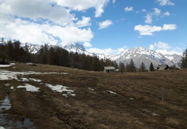
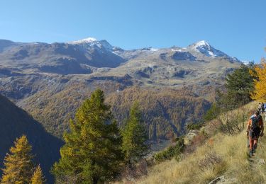
Trail Walking of 22 km to be discovered at Provence-Alpes-Côte d'Azur, Hautes-Alpes, L'Argentière-la-Bessée. This trail is proposed by jpb83.

Description

Pour rejoindre le Champsaur par le Pas de la Cavale, un sentier court le long du vallon du Fournel, tout en douceur. Une longue randonnée dans un paysage des plus sauvages.

Elevation profile

Points of interest

Positioning

Country:
France
Region :
Provence-Alpes-Côte d'Azur
Department/Province :
Hautes-Alpes
Municipality :
L'Argentière-la-Bessée
Location:
Unknown
Start:(UTM)
299052 ; 4962590 (32T) N.

Trails nearby

Trail Walking Puy-Saint-Vincent - La tête d'Oreac - Photo
Walking
Sigmut

Walking

Easy
(2)
Puy-Saint-Vincent, Provence-Alpes-Côte d'Azur, Hautes-Alpes, France
6 km | 10.4 km-effort
3h 55min
Yes
Trail Walking Puy-Saint-Vincent - Cascades de Narreyroux - Puy Saint Vincent - Photo
Walking
tracegps

Walking

Difficult
(1)
Puy-Saint-Vincent, Provence-Alpes-Côte d'Azur, Hautes-Alpes, France
11.4 km | 19.2 km-effort
4h 0min
Yes
Trail Walking Vallouise-Pelvoux - refuge des bancs  - Photo
Walking
Philou888

Walking

Easy
(1)
Vallouise-Pelvoux, Provence-Alpes-Côte d'Azur, Hautes-Alpes, France
9.3 km | 16.1 km-effort
3h 4min
Yes
Trail On foot Vallouise-Pelvoux - Boucle de Vallouise - Photo
On foot
GUIDE+

On foot

Easy
Vallouise-Pelvoux, Provence-Alpes-Côte d'Azur, Hautes-Alpes, France
8.1 km | 11.6 km-effort
2h 38min
Yes
Trail Snowshoes Puy-Saint-Vincent - la tête d'Oréac - Photo
Snowshoes
GUIDE
amiral13

Snowshoes

Medium
Puy-Saint-Vincent, Provence-Alpes-Côte d'Azur, Hautes-Alpes, France
6.4 km | 11.4 km-effort
4h 7min
Yes
Trail Walking Puy-Saint-Vincent - le lac des Hermes - Photo
Walking
GUIDE
amiral13

Walking

Easy
Puy-Saint-Vincent, Provence-Alpes-Côte d'Azur, Hautes-Alpes, France
4.3 km | 6.5 km-effort
3h 9min
Yes
Trail Walking Puy-Saint-Vincent - Narreyroux au départ de PSV 1600 - Photo
Walking
GUIDE
amiral13

Walking

Very easy
Puy-Saint-Vincent, Provence-Alpes-Côte d'Azur, Hautes-Alpes, France
4.6 km | 6.3 km-effort
1h 49min
Yes
Trail Walking Puy-Saint-Vincent - Boucle col de la Pousterle et tête d'Oréac - Photo
Walking
GUIDE
amiral13

Walking

Medium
Puy-Saint-Vincent, Provence-Alpes-Côte d'Azur, Hautes-Alpes, France
9.5 km | 15.5 km-effort
3h 9min
Yes
Trail Walking Freissinières - les Violins  Dormillouse  - Photo
Walking
GUIDE
orsel

Walking

Easy
Freissinières, Provence-Alpes-Côte d'Azur, Hautes-Alpes, France
14.8 km | 28 km-effort
9h 14min
Yes


Close
My subscriptions