![](/images/other/stat-length.png)
![Trail Walking Beyrède-Jumet-Camous - Le signal de Bassia depuis le col de Beyrède - Photo](https://media.geolcdn.com/t/1900/400/ext.pjpeg?maxdim=2&url=https%3A%2F%2Fstatic1.geolcdn.com%2Fsiteimages%2Fupload%2Ffiles%2F1553511878bg_sport_marche.png)
Le signal de Bassia depuis le col de Beyrède
2033
User
![Length](/images/other/stat-length.png)
![Max alt](https://static1.geolcdn.com/siteimages/upload/files/1508320355ic_sort_altitude_max_24dp.png)
![Uphill gradient](https://static1.geolcdn.com/siteimages/upload/files/1508320355ic_sort_den_pos_24dp.png)
![Km-Effort](/images/other/stat-length.png)
![Min alt](https://static1.geolcdn.com/siteimages/upload/files/1508320355ic_sort_altitude_min_24dp.png)
![Downhill gradient](https://static1.geolcdn.com/siteimages/upload/files/1508320355ic_sort_den_neg_24dp.png)
![Boucle](https://static1.geolcdn.com/siteimages/upload/files/16400158638029165_repeat_loop_refresh_sync_direction_icon.png)
![Walking](https://static1.geolcdn.com/sitytour/trail-icons/101.png)
1h53
Difficulty : Medium
![Scan this QR Code to open this trail in the SityTrail application](https://capi.geolives.com/qq0zvz2zws4bq2lad0pu/sitytour/trails/451595/qr.png?size=200)
FREE GPS app for hiking
About
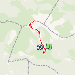
Trail Walking of 4.1 km to be discovered at Occitania, Hautespyrenees, Beyrède-Jumet-Camous. This trail is proposed by 2033.
Description
Accès voiture:
De Campan à Ste Marie de Campan, puis direction col d'Aspin. 2 km après la Séoube, juste en dessous du plateau de Payolle, prendre à gauche en direction du Col de Beyrède.
Passer un premier col et se garer au large col de Beyrède.
Départ alt 1 410 m. Prendre plein nord une large piste. Un balisage jaune est présent jusqu'au sommet. Le sentier part sur la gauche en traversée montante et pénètre dans la forêt. Après le passage d'un petit ressaut, le sentier continue vers l'ouest.
Atteindre le col à l'altitude 1865 m, et poursuivre vers la droite (est) en suivant la crête. On arrive au sommet (relais télécom), alt 1 921 m, en 1h 45. Le marquage jaune s'arrête. Superbe vue sur Les Baronnies, sur une partie de la Vallée d'Aure et sur le massif du Pic du Midi.
Positioning
Comments
Trails nearby
![Trail Walking Esparros - Du Signal de Bassia vers le col de Beyrède par la crête sud-est et le Pas de Bassia - Photo](https://media.geolcdn.com/t/375/260/ext.jpg?maxdim=2&url=https%3A%2F%2Fstatic1.geolcdn.com%2Fsiteimages%2Fupload%2Ffiles%2F1553511878bg_sport_marche.png)
![Walking Walking](https://static1.geolcdn.com/sitytour/trail-icons/101.png)
Walking
![](/images/other/stat-length.png)
![](https://static1.geolcdn.com/siteimages/upload/files/16400158638029165_repeat_loop_refresh_sync_direction_icon.png)
![Trail Walking Ancizan - Vallée de la Gaoube - Photo](https://media.geolcdn.com/t/375/260/e9b5d96b-48c0-4d82-9142-57559dc5c2b3.jpg&format=jpg&maxdim=2)
![Walking Walking](https://static1.geolcdn.com/sitytour/trail-icons/101.png)
Walking
![](/images/other/stat-length.png)
![](https://static1.geolcdn.com/siteimages/upload/files/16400158638029165_repeat_loop_refresh_sync_direction_icon.png)
![Trail Walking Beyrède-Jumet-Camous - Signal de Bassia de Hèche - Photo](https://media.geolcdn.com/t/375/260/ext.jpg?maxdim=2&url=https%3A%2F%2Fservices.sitytrail.com%2FGeolivesWS%2FDownloadMedia.ashx%3FTrailID%3D101301%26Media%3D796_2.jpg)
![Walking Walking](https://static1.geolcdn.com/sitytour/trail-icons/101.png)
Walking
![](/images/other/stat-length.png)
![](https://static1.geolcdn.com/siteimages/upload/files/16400158638029165_repeat_loop_refresh_sync_direction_icon.png)
![Trail On foot Campan - Boucle d'Espiadet - Photo](https://media.geolcdn.com/t/375/260/0625399b-d0a9-424d-94f3-d72094f23909.jpeg&format=jpg&maxdim=2)
![On foot On foot](https://static1.geolcdn.com/sitytour/trail-icons/100.png)
On foot
![](/images/other/stat-length.png)
![](https://static1.geolcdn.com/siteimages/upload/files/16400158638029165_repeat_loop_refresh_sync_direction_icon.png)
![Trail Walking Campan - Pic de Bassia, Pic du Castillon, Pic de Paou - Photo](https://media.geolcdn.com/t/375/260/ext.jpg?maxdim=2&url=https%3A%2F%2Fstatic1.geolcdn.com%2Fsiteimages%2Fupload%2Ffiles%2F1553511878bg_sport_marche.png)
![Walking Walking](https://static1.geolcdn.com/sitytour/trail-icons/101.png)
Walking
![](/images/other/stat-length.png)
![](https://static1.geolcdn.com/siteimages/upload/files/16400158638029165_repeat_loop_refresh_sync_direction_icon.png)
![Trail Snowshoes Campan - raquet 1 - Photo](https://media.geolcdn.com/t/375/260/ext.jpg?maxdim=2&url=https%3A%2F%2Fstatic1.geolcdn.com%2Fsiteimages%2Fupload%2Ffiles%2F1524743153raquette.jpg)
![Snowshoes Snowshoes](https://static1.geolcdn.com/sitytour/trail-icons/504.png)
Snowshoes
![](/images/other/stat-length.png)
![](https://static1.geolcdn.com/siteimages/upload/files/16400158638029165_repeat_loop_refresh_sync_direction_icon.png)
![Trail Walking Campan - payolle - Photo](https://media.geolcdn.com/t/375/260/ext.jpg?maxdim=2&url=https%3A%2F%2Fstatic1.geolcdn.com%2Fsiteimages%2Fupload%2Ffiles%2F1553511878bg_sport_marche.png)
![Walking Walking](https://static1.geolcdn.com/sitytour/trail-icons/101.png)
Walking
![](/images/other/stat-length.png)
![](https://static1.geolcdn.com/siteimages/upload/files/16400158638029165_repeat_loop_refresh_sync_direction_icon.png)
![Trail Walking Campan - G2B payolle gleyse 2024 - Photo](https://media.geolcdn.com/t/375/260/6d136f9a-e460-46c2-88bb-41345f157e89.jpg&format=jpg&maxdim=2)
![Walking Walking](https://static1.geolcdn.com/sitytour/trail-icons/101.png)
Walking
![](/images/other/stat-length.png)
![](https://static1.geolcdn.com/siteimages/upload/files/16400158638029165_repeat_loop_refresh_sync_direction_icon.png)
![Trail Walking Beyrède-Jumet-Camous - Signal de Bassia via le Cap de Paou - Photo](https://media.geolcdn.com/t/375/260/0052c0ce-f697-4df9-9476-248b8662c9ce.jpg&format=jpg&maxdim=2)
![Walking Walking](https://static1.geolcdn.com/sitytour/trail-icons/101.png)
Walking
![](/images/other/stat-length.png)
![](https://static1.geolcdn.com/siteimages/upload/files/16400158638029165_repeat_loop_refresh_sync_direction_icon.png)