


tour de hsipaw

mapomme
User
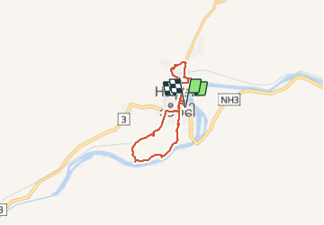

Length
19.5 km

Max alt
440 m

Uphill gradient
157 m
Km-Effort
22 km

Min alt
408 m

Downhill gradient
157 m
Boucle
Yes
Creation date :
2015-07-29 00:00:00.0
Updated on :
2015-07-29 00:00:00.0
7h17
Difficulty : Very easy

FREE GPS app for hiking
 SityTrail
IGN / Geographical institutes
SityTrail World
The world is yours!
About
Trail Walking of 19.5 km to be discovered at Shan State, Kyaukme District. This trail is proposed by mapomme.
Description
Palais Shan, little Bagan, rizières et villages Shan
Positioning
Country:
Myanmar
Region :
Shan State
Department/Province :
Kyaukme District
Municipality :
Unknown
Location:
Unknown
Start:(Dec)
Start:(UTM)
325514 ; 2502119 (47Q) N.
Comments
Trails nearby