![](/images/other/stat-length.png)
![Trail Walking Termes - TERMES 48 - petit circuit - Photo](https://media.geolcdn.com/t/1900/400/ext.pjpeg?maxdim=2&url=https%3A%2F%2Fservices.sitytrail.com%2FGeolivesWS%2FDownloadMedia.ashx%3FTrailID%3D445926%26Media%3D20150712174806.jpg)
TERMES 48 - petit circuit
jeff66
User
![Length](/images/other/stat-length.png)
Length
7.3 km
![Max alt](https://static1.geolcdn.com/siteimages/upload/files/1508320355ic_sort_altitude_max_24dp.png)
Max alt
1216 m
![Uphill gradient](https://static1.geolcdn.com/siteimages/upload/files/1508320355ic_sort_den_pos_24dp.png)
Uphill gradient
119 m
![Km-Effort](/images/other/stat-length.png)
Km-Effort
8.8 km
![Min alt](https://static1.geolcdn.com/siteimages/upload/files/1508320355ic_sort_altitude_min_24dp.png)
Min alt
1120 m
![Downhill gradient](https://static1.geolcdn.com/siteimages/upload/files/1508320355ic_sort_den_neg_24dp.png)
Downhill gradient
120 m
![Boucle](https://static1.geolcdn.com/siteimages/upload/files/16400158638029165_repeat_loop_refresh_sync_direction_icon.png)
Boucle
Yes
Creation date :
2015-07-17 00:00:00.0
Updated on :
2015-07-17 00:00:00.0
![Walking](https://static1.geolcdn.com/sitytour/trail-icons/101.png)
1h46
Difficulty : Easy
![Scan this QR Code to open this trail in the SityTrail application](https://capi.geolives.com/qq0zvz2zws4bq2lad0pu/sitytour/trails/445926/qr.png?size=200)
FREE GPS app for hiking
About
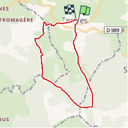
Trail Walking of 7.3 km to be discovered at Occitania, Lozère, Termes. This trail is proposed by jeff66.
Description
TERMES 48 - pont du renard - Las Barros - GR de pays du tour des monts d'aubrac - bois de Lachant - plos de Bouos - la Giroune - Lachant - le Mazuc de Vassal
Positioning
Country:
France
Region :
Occitania
Department/Province :
Lozère
Municipality :
Termes
Location:
Unknown
Start:(Dec)
Start:(UTM)
513283 ; 4962182 (31T) N.
Comments
Trails nearby
![Trail Walking Termes - Termes Aumont aubrac - Photo](https://media.geolcdn.com/t/375/260/f87d16b1-1f73-4a88-8df5-61d0347ec4b8.jpg&format=jpg&maxdim=2)
![Walking Walking](https://static1.geolcdn.com/sitytour/trail-icons/101.png)
Termes Aumont aubrac
Walking
Medium
Termes,
Occitania,
Lozère,
France
![](/images/other/stat-length.png)
19.1 km | 23 km-effort
7h 22min
![](https://static1.geolcdn.com/siteimages/upload/files/16400158638029165_repeat_loop_refresh_sync_direction_icon.png)
No
![Trail Walking Termes - TERMES 48 - autour de la Rau de la FAGE - Photo](https://media.geolcdn.com/t/375/260/ext.jpg?maxdim=2&url=https%3A%2F%2Fservices.sitytrail.com%2FGeolivesWS%2FDownloadMedia.ashx%3FTrailID%3D445928%26Media%3D20150715150322.jpg)
![Walking Walking](https://static1.geolcdn.com/sitytour/trail-icons/101.png)
TERMES 48 - autour de la Rau de la FAGE
Walking
Medium
Termes,
Occitania,
Lozère,
France
![](/images/other/stat-length.png)
12.2 km | 15.4 km-effort
2h 36min
![](https://static1.geolcdn.com/siteimages/upload/files/16400158638029165_repeat_loop_refresh_sync_direction_icon.png)
Yes
![Trail Walking Fournels - De Fournels à St-Chély-d'Apcher - Photo](https://media.geolcdn.com/t/375/260/ext.jpg?maxdim=2&url=https%3A%2F%2Fservices.sitytrail.com%2FGeolivesWS%2FDownloadMedia.ashx%3FTrailID%3D172923%26Media%3D14391_4.jpg)
![Walking Walking](https://static1.geolcdn.com/sitytour/trail-icons/101.png)
De Fournels à St-Chély-d'Apcher
Walking
Difficult
Fournels,
Occitania,
Lozère,
France
![](/images/other/stat-length.png)
17.7 km | 23 km-effort
4h 10min
![](https://static1.geolcdn.com/siteimages/upload/files/16400158638029165_repeat_loop_refresh_sync_direction_icon.png)
No
![Trail Electric bike Termes - Narce-La Fage Montivernoux - Photo](https://media.geolcdn.com/t/375/260/ext.jpg?maxdim=2&url=https%3A%2F%2Fstatic1.geolcdn.com%2Fsiteimages%2Fupload%2Ffiles%2F1524743154velo.jpg)
![Electric bike Electric bike](https://static1.geolcdn.com/sitytour/trail-icons/205.png)
Narce-La Fage Montivernoux
Electric bike
Easy
Termes,
Occitania,
Lozère,
France
![](/images/other/stat-length.png)
23 km | 30 km-effort
Unknown
![](https://static1.geolcdn.com/siteimages/upload/files/16400158638029165_repeat_loop_refresh_sync_direction_icon.png)
Yes
![Trail Walking Termes - Chantejals 2 - Photo](https://media.geolcdn.com/t/375/260/ext.jpg?maxdim=2&url=https%3A%2F%2Fstatic1.geolcdn.com%2Fsiteimages%2Fupload%2Ffiles%2F1553511878bg_sport_marche.png)
![Walking Walking](https://static1.geolcdn.com/sitytour/trail-icons/101.png)
![Trail Walking Termes - Chantejals - Photo](https://media.geolcdn.com/t/375/260/ext.jpg?maxdim=2&url=https%3A%2F%2Fstatic1.geolcdn.com%2Fsiteimages%2Fupload%2Ffiles%2F1553511878bg_sport_marche.png)
![Walking Walking](https://static1.geolcdn.com/sitytour/trail-icons/101.png)
Chantejals
Walking
Difficult
Termes,
Occitania,
Lozère,
France
![](/images/other/stat-length.png)
14.4 km | 17.9 km-effort
5h 47min
![](https://static1.geolcdn.com/siteimages/upload/files/16400158638029165_repeat_loop_refresh_sync_direction_icon.png)
Yes
![Trail Horseback riding Termes - Etoile Truc de L'Homme 31 km - Photo](https://media.geolcdn.com/t/375/260/ext.jpg?maxdim=2&url=https%3A%2F%2Fstatic1.geolcdn.com%2Fsiteimages%2Fupload%2Ffiles%2F1524743154cheval.jpg)
![Horseback riding Horseback riding](https://static1.geolcdn.com/sitytour/trail-icons/301.png)
Etoile Truc de L'Homme 31 km
Horseback riding
Medium
Termes,
Occitania,
Lozère,
France
![](/images/other/stat-length.png)
31 km | 42 km-effort
2h 43min
![](https://static1.geolcdn.com/siteimages/upload/files/16400158638029165_repeat_loop_refresh_sync_direction_icon.png)
Yes
![Trail Mountain bike Les Monts-Verts - Berc - Le Bacon vieux - Trémoulouzet - Photo](https://media.geolcdn.com/t/375/260/b9480954-31af-4fbf-b464-dd8510deec66.jpg&format=jpg&maxdim=2)
![Mountain bike Mountain bike](https://static1.geolcdn.com/sitytour/trail-icons/202.png)
Berc - Le Bacon vieux - Trémoulouzet
Mountain bike
Medium
Les Monts-Verts,
Occitania,
Lozère,
France
![](/images/other/stat-length.png)
11.7 km | 15 km-effort
1h 15min
![](https://static1.geolcdn.com/siteimages/upload/files/16400158638029165_repeat_loop_refresh_sync_direction_icon.png)
Yes
![Trail Mountain bike Les Monts-Verts - Le Puech de Berc - Photo](https://media.geolcdn.com/t/375/260/eaabeb4f-f5b1-417b-964a-e0cc050e1bcf.jpg&format=jpg&maxdim=2)
![Mountain bike Mountain bike](https://static1.geolcdn.com/sitytour/trail-icons/202.png)
Le Puech de Berc
Mountain bike
Easy
Les Monts-Verts,
Occitania,
Lozère,
France
![](/images/other/stat-length.png)
8.7 km | 10.9 km-effort
50min
![](https://static1.geolcdn.com/siteimages/upload/files/16400158638029165_repeat_loop_refresh_sync_direction_icon.png)
Yes