Trail Walking Aime-la-Plagne - Refuge du Presset - Photo
 ilur56
ilur56

User

© OpenStreetMap contributors
Length
Length
12.8 km
Max alt
Max alt
2494 m
Uphill gradient
Uphill gradient
1122 m
Km-Effort
Km-Effort  
26 km
Min alt
Min alt
1839 m
Downhill gradient
Downhill gradient
509 m
Boucle
Boucle
No
Creation date :
2015-07-15 00:00:00.0
Updated on :
2015-07-15 00:00:00.0

(0 Reviews)

Walking
Walking
5h50
Difficulty : Medium

Scan this QR Code to open this trail in the SityTrail application

FREE GPS app for hiking

Logo SityTrail SityTrail

IGN / Geographical institutes

Download SityTrail from the App Store Download SityTrail from Google Play

Logo SityTrail SityTrail World

The world is yours!

Download SityTrail from the App Store Download SityTrail from Google Play Download SityTrail on Huawei AppGallery

About

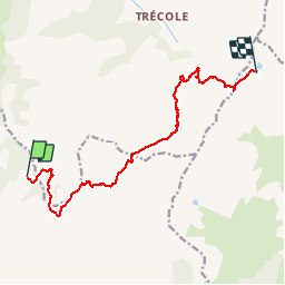
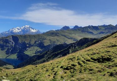
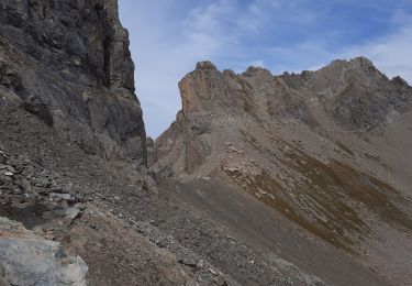
Trail Walking of 12.8 km to be discovered at Auvergne-Rhône-Alpes, Savoy, Aime-la-Plagne. This trail is proposed by ilur56.
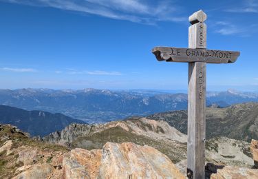
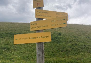
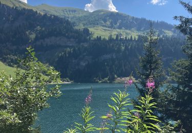
Description

Tour du Beaufortain
Sixième étape ente l'Econdu et le Presset

Elevation profile

Positioning

Country:
France
Region :
Auvergne-Rhône-Alpes
Department/Province :
Savoy
Municipality :
Aime-la-Plagne
Location:
Granier
Start:(UTM)
312352 ; 5055288 (32T) N.

Trails nearby

Trail Walking Aime-la-Plagne - 2024-09-08 Marche Tour Beaufortain Refuge Coire vers Refuge Presset - Photo
Walking
GUIDE
holtzv

Walking

Very difficult
Aime-la-Plagne, Auvergne-Rhône-Alpes, Savoy, France
13.6 km | 26 km-effort
5h 48min
No
Trail Walking Beaufort - suuntoapp-Hiking-2024-09-07T06-03-31Z - Photo
Walking
GUIDE
holtzv

Walking

Very difficult
Beaufort, Auvergne-Rhône-Alpes, Savoy, France
21 km | 38 km-effort
8h 42min
No
Trail Walking Beaufort - lac de Presset et passeur de la Mintaz (belvédère de la Pierra Menta) - Photo
Walking
GUIDE
amiral13

Walking

Difficult
Beaufort, Auvergne-Rhône-Alpes, Savoy, France
11.6 km | 24 km-effort
2h 57min
Yes
Trail Walking Beaufort - Lac d’Amour - col du Coin 10 km -680 m dénivelé + - Photo
Walking
GUIDE
rvapeldo

Walking

Medium
Beaufort, Auvergne-Rhône-Alpes, Savoy, France
10.4 km | 19.6 km-effort
7h 5min
Yes
Trail Walking Beaufort - Barrage St Guerin Refuge de l’Econdu 12 km - 600 m d’en + - Photo
Walking
GUIDE
rvapeldo

Walking

Medium
Beaufort, Auvergne-Rhône-Alpes, Savoy, France
11.9 km | 20 km-effort
5h 39min
Yes
Trail Walking Beaufort - St guerin - cormet d Arêches - miraillet- mirallet - Photo
Walking
lolitrail

Walking

Medium
Beaufort, Auvergne-Rhône-Alpes, Savoy, France
17 km | 29 km-effort
4h 15min
No
Trail Walking Beaufort - St guerin - Arêches via l alpage - Photo
Walking
lolitrail

Walking

Medium
Beaufort, Auvergne-Rhône-Alpes, Savoy, France
13.8 km | 24 km-effort
3h 51min
No
Trail Walking La Léchère - lacs de la tempête - Photo
Walking
GuyVachet

Walking

Very difficult
La Léchère, Auvergne-Rhône-Alpes, Savoy, France
14.8 km | 25 km-effort
7h 10min
Yes
Trail Walking Beaufort - Brèche de Parozan - Photo
Walking
GuyVachet

Walking

Very difficult
Beaufort, Auvergne-Rhône-Alpes, Savoy, France
9.6 km | 23 km-effort
4h 29min
Yes


Close
My subscriptions