![](/images/other/stat-length.png)
![Trail Walking Grächen - YHH073 Grächen - Herbriggen - Photo](https://media.geolcdn.com/t/1900/400/ext.pjpeg?maxdim=2&url=https%3A%2F%2Fstatic1.geolcdn.com%2Fsiteimages%2Fupload%2Ffiles%2F1553511878bg_sport_marche.png)
YHH073 Grächen - Herbriggen
yveshumbert
User
![Length](/images/other/stat-length.png)
Length
12.4 km
![Max alt](https://static1.geolcdn.com/siteimages/upload/files/1508320355ic_sort_altitude_max_24dp.png)
Max alt
1704 m
![Uphill gradient](https://static1.geolcdn.com/siteimages/upload/files/1508320355ic_sort_den_pos_24dp.png)
Uphill gradient
298 m
![Km-Effort](/images/other/stat-length.png)
Km-Effort
17.5 km
![Min alt](https://static1.geolcdn.com/siteimages/upload/files/1508320355ic_sort_altitude_min_24dp.png)
Min alt
1223 m
![Downhill gradient](https://static1.geolcdn.com/siteimages/upload/files/1508320355ic_sort_den_neg_24dp.png)
Downhill gradient
652 m
![Boucle](https://static1.geolcdn.com/siteimages/upload/files/16400158638029165_repeat_loop_refresh_sync_direction_icon.png)
Boucle
No
Creation date :
2014-12-10 00:00:00.0
Updated on :
2014-12-10 00:00:00.0
![Walking](https://static1.geolcdn.com/sitytour/trail-icons/101.png)
4h30
Difficulty : Unknown
![Scan this QR Code to open this trail in the SityTrail application](https://capi.geolives.com/qq0zvz2zws4bq2lad0pu/sitytour/trails/44537/qr.png?size=200)
FREE GPS app for hiking
About
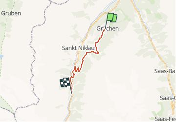
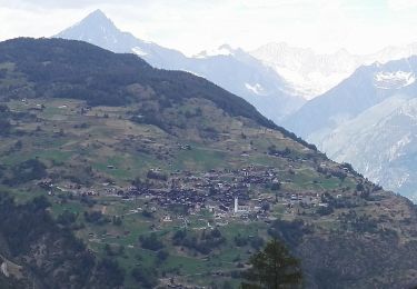
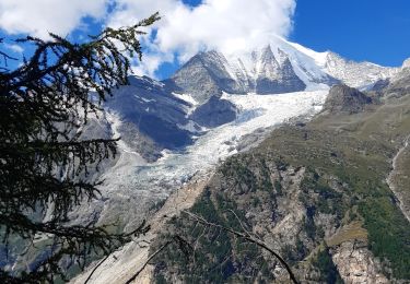
Trail Walking of 12.4 km to be discovered at Valais/Wallis, Visp, Grächen. This trail is proposed by yveshumbert.
Description
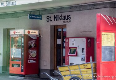
Pendant cette randonnée on suit un chemin à flanc le long de la vallée de Zermatt. On descend dans la vallée au niveau de Herbriggen. Le retour se fait en car postale ou en train (vérifier les horaires avant de partir)
Positioning
Country:
Switzerland
Region :
Valais/Wallis
Department/Province :
Visp
Municipality :
Grächen
Location:
Unknown
Start:(Dec)
Start:(UTM)
410394 ; 5116385 (32T) N.
Comments
Trails nearby
![Trail On foot Grächen - Grächen-St. Niklaus - Photo](https://media.geolcdn.com/t/375/260/ext.jpg?maxdim=2&url=https%3A%2F%2Fmedia.geolcdn.com%2Ff%2F27fabdfb-4bab-4a73-9b5c-c2b30f7601b1.jpeg)
![On foot On foot](https://static1.geolcdn.com/sitytour/trail-icons/100.png)
Grächen-St. Niklaus
On foot
Easy
Grächen,
Valais/Wallis,
Visp,
Switzerland
![](/images/other/stat-length.png)
4.3 km | 6.2 km-effort
1h 23min
![](https://static1.geolcdn.com/siteimages/upload/files/16400158638029165_repeat_loop_refresh_sync_direction_icon.png)
No
![Trail On foot Grächen - Hannigalp-Saas-Fee - Photo](https://media.geolcdn.com/t/375/260/ext.jpg?maxdim=2&url=https%3A%2F%2Fmedia.geolcdn.com%2Ff%2F13565212-d8f8-4a73-b70e-442e2ce34d21.jpeg)
![On foot On foot](https://static1.geolcdn.com/sitytour/trail-icons/100.png)
Hannigalp-Saas-Fee
On foot
Medium
Grächen,
Valais/Wallis,
Visp,
Switzerland
![](/images/other/stat-length.png)
14.4 km | 25 km-effort
5h 39min
![](https://static1.geolcdn.com/siteimages/upload/files/16400158638029165_repeat_loop_refresh_sync_direction_icon.png)
No
![Trail On foot St. Niklaus - St. Niklaus - Jungu - Photo](https://media.geolcdn.com/t/375/260/ext.jpg?maxdim=2&url=https%3A%2F%2Fmedia.geolcdn.com%2Ff%2Fe9e7da26-cfc6-42ac-9275-6ff2bda77838.jpeg)
![On foot On foot](https://static1.geolcdn.com/sitytour/trail-icons/100.png)
St. Niklaus - Jungu
On foot
Easy
St. Niklaus,
Valais/Wallis,
Visp,
Switzerland
![](/images/other/stat-length.png)
4.1 km | 12.3 km-effort
2h 48min
![](https://static1.geolcdn.com/siteimages/upload/files/16400158638029165_repeat_loop_refresh_sync_direction_icon.png)
No
![Trail On foot St. Niklaus - Untere Läger-Augstbordpass - Photo](https://media.geolcdn.com/t/375/260/ext.jpg?maxdim=2&url=https%3A%2F%2Fmedia.geolcdn.com%2Ff%2Fe9e7da26-cfc6-42ac-9275-6ff2bda77838.jpeg)
![On foot On foot](https://static1.geolcdn.com/sitytour/trail-icons/100.png)
Untere Läger-Augstbordpass
On foot
Easy
St. Niklaus,
Valais/Wallis,
Visp,
Switzerland
![](/images/other/stat-length.png)
5.5 km | 12.5 km-effort
2h 50min
![](https://static1.geolcdn.com/siteimages/upload/files/16400158638029165_repeat_loop_refresh_sync_direction_icon.png)
No
![Trail Walking Grächen - Grächen et ses bisses 07.2018 - Photo](https://media.geolcdn.com/t/375/260/ext.jpg?maxdim=2&url=https%3A%2F%2Fservices.sitytrail.com%2FGeolivesWS%2FDownloadMedia.ashx%3FTrailID%3D1004149%26Media%3D8093b6a4-1bb2-49b2-80d3-6c3b30602d2f.jpg)
![Walking Walking](https://static1.geolcdn.com/sitytour/trail-icons/101.png)
Grächen et ses bisses 07.2018
Walking
Medium
Grächen,
Valais/Wallis,
Visp,
Switzerland
![](/images/other/stat-length.png)
14.1 km | 19.8 km-effort
4h 10min
![](https://static1.geolcdn.com/siteimages/upload/files/16400158638029165_repeat_loop_refresh_sync_direction_icon.png)
Yes
![Trail Walking St. Niklaus - St Niklaus - Europahutte / Jour 10 - Photo](https://media.geolcdn.com/t/375/260/ext.jpg?maxdim=2&url=https%3A%2F%2Fmedia.geolcdn.com%2Ff%2F80e64528-d2bf-49c5-869c-d28ac7478b9b.jpg)
![Walking Walking](https://static1.geolcdn.com/sitytour/trail-icons/101.png)
St Niklaus - Europahutte / Jour 10
Walking
Difficult
St. Niklaus,
Valais/Wallis,
Visp,
Switzerland
![](/images/other/stat-length.png)
12.2 km | 26 km-effort
4h 3min
![](https://static1.geolcdn.com/siteimages/upload/files/16400158638029165_repeat_loop_refresh_sync_direction_icon.png)
No
![Trail Other activity Staldenried - sf10_e11c - Photo](https://media.geolcdn.com/t/375/260/ext.jpg?maxdim=2&url=https%3A%2F%2Fstatic1.geolcdn.com%2Fsiteimages%2Fupload%2Ffiles%2F1545311037marcheuse_200dpi.jpg)
![Other activity Other activity](https://static1.geolcdn.com/sitytour/trail-icons/900.png)
sf10_e11c
Other activity
Very easy
Staldenried,
Valais/Wallis,
Visp,
Switzerland
![](/images/other/stat-length.png)
19.3 km | 35 km-effort
8h 30min
![](https://static1.geolcdn.com/siteimages/upload/files/16400158638029165_repeat_loop_refresh_sync_direction_icon.png)
No
![Trail Other activity Staldenried - y10_gspon_saas - Photo](https://media.geolcdn.com/t/375/260/ext.jpg?maxdim=2&url=https%3A%2F%2Fstatic1.geolcdn.com%2Fsiteimages%2Fupload%2Ffiles%2F1545311037marcheuse_200dpi.jpg)
![Other activity Other activity](https://static1.geolcdn.com/sitytour/trail-icons/900.png)
y10_gspon_saas
Other activity
Very easy
Staldenried,
Valais/Wallis,
Visp,
Switzerland
![](/images/other/stat-length.png)
19.3 km | 33 km-effort
7h 50min
![](https://static1.geolcdn.com/siteimages/upload/files/16400158638029165_repeat_loop_refresh_sync_direction_icon.png)
No
![Trail Mountain bike Staldenried - Gspon - Photo](https://media.geolcdn.com/t/375/260/ext.jpg?maxdim=2&url=https%3A%2F%2Fstatic1.geolcdn.com%2Fsiteimages%2Fupload%2Ffiles%2F1524743154velo.jpg)
![Mountain bike Mountain bike](https://static1.geolcdn.com/sitytour/trail-icons/202.png)
Gspon
Mountain bike
Very easy
Staldenried,
Valais/Wallis,
Visp,
Switzerland
![](/images/other/stat-length.png)
22 km | 33 km-effort
7h 51min
![](https://static1.geolcdn.com/siteimages/upload/files/16400158638029165_repeat_loop_refresh_sync_direction_icon.png)
No