Trail Other activity Erstfeld - Sunnig Täler Höhenweg + Panoramaweg - Photo

Sunnig Täler Höhenweg + Panoramaweg

© OpenStreetMap contributors
Length
Length
20 km
Max alt
Max alt
2402 m
Uphill gradient
Uphill gradient
1915 m
Km-Effort
Km-Effort  
45 km
Min alt
Min alt
1070 m
Downhill gradient
Downhill gradient
1713 m
Boucle
Boucle
No
Creation date :
2014-12-10 00:00:00.0
Updated on :
2014-12-10 00:00:00.0

(0 Reviews)

Other activity
Other activity
--
Difficulty : Unknown

Scan this QR Code to open this trail in the SityTrail application

FREE GPS app for hiking

Logo SityTrail SityTrail

IGN / Geographical institutes

Download SityTrail from the App Store Download SityTrail from Google Play

Logo SityTrail SityTrail World

The world is yours!

Download SityTrail from the App Store Download SityTrail from Google Play Download SityTrail on Huawei AppGallery

About

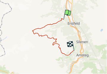
Trail Other activity of 20 km to be discovered at Uri, Unknown, Erstfeld. This trail is proposed by alternatives-wandern.

Description

Detailbeschreibung siehe :
www.alternatives-wandern.ch/touren/trekking/sunnigtaeler.htm

Elevation profile

Positioning

Country:
Switzerland
Region :
Uri
Department/Province :
Unknown
Municipality :
Erstfeld
Location:
Unknown
Start:(UTM)
471553 ; 5186061 (32T) N.

Trails nearby

Trail On foot Erstfeld - Erstfeld-Attighauser Brücke - Photo
On foot
GUIDE+

On foot

Easy
Erstfeld, Uri, Unknown, Switzerland
5.5 km | 6.8 km-effort
1h 32min
No
Trail On foot Silenen - Silenen-Erstfeld - Photo
On foot
GUIDE+

On foot

Easy
Silenen, Uri, Unknown, Switzerland
3.7 km | 4 km-effort
54min
No
Trail On foot Attinghausen - Höchiberg - FIXME - Photo
On foot
GUIDE+

On foot

Easy
Attinghausen, Uri, Unknown, Switzerland
3 km | 5.8 km-effort
1h 19min
No
Trail Other activity Attinghausen - y10_surenen - Photo
Other activity
GUIDE+

Other activity

Very easy
Attinghausen, Uri, Unknown, Switzerland
13.3 km | 26 km-effort
Unknown
No
Trail Other activity Erstfeld - y10_Erstfeld_Goeschenen - Photo
Other activity
GUIDE+

Other activity

Very easy
Erstfeld, Uri, Unknown, Switzerland
23 km | 35 km-effort
8h 51min
No
Trail Other activity Erstfeld - y10_Erstfeldertal_Kroenten - Photo
Other activity
GUIDE+

Other activity

Very easy
Erstfeld, Uri, Unknown, Switzerland
9.5 km | 22 km-effort
5h 27min
No
Trail Other activity Attinghausen - Brüsti-Fürenalp - Photo
Other activity
Dgubler

Other activity

Very easy
Attinghausen, Uri, Unknown, Switzerland
13 km | 26 km-effort
5h 56min
No
Trail Walking Attinghausen - Attinghausen - Engelberg - Photo
Walking
Dgubler

Walking

Very easy
Attinghausen, Uri, Unknown, Switzerland
20 km | 34 km-effort
7h 45min
No
Trail Other activity Erstfeld - Surenen - Photo
Other activity
chgeo

Other activity

Very easy
Erstfeld, Uri, Unknown, Switzerland
3.4 km | 6.4 km-effort
Unknown
No


Close
My subscriptions