![](/images/other/stat-length.png)
![Trail Walking PUILAURENS - La Serre des Aiguilles - Photo](https://media.geolcdn.com/t/1900/400/ext.pjpeg?maxdim=2&url=https%3A%2F%2Fstatic1.geolcdn.com%2Fsiteimages%2Fupload%2Ffiles%2F1553511878bg_sport_marche.png)
La Serre des Aiguilles
7217Lionel
User
![Length](/images/other/stat-length.png)
Length
14.3 km
![Max alt](https://static1.geolcdn.com/siteimages/upload/files/1508320355ic_sort_altitude_max_24dp.png)
Max alt
820 m
![Uphill gradient](https://static1.geolcdn.com/siteimages/upload/files/1508320355ic_sort_den_pos_24dp.png)
Uphill gradient
551 m
![Km-Effort](/images/other/stat-length.png)
Km-Effort
22 km
![Min alt](https://static1.geolcdn.com/siteimages/upload/files/1508320355ic_sort_altitude_min_24dp.png)
Min alt
461 m
![Downhill gradient](https://static1.geolcdn.com/siteimages/upload/files/1508320355ic_sort_den_neg_24dp.png)
Downhill gradient
553 m
![Boucle](https://static1.geolcdn.com/siteimages/upload/files/16400158638029165_repeat_loop_refresh_sync_direction_icon.png)
Boucle
Yes
Creation date :
2015-07-05 00:00:00.0
Updated on :
2015-07-05 00:00:00.0
![Walking](https://static1.geolcdn.com/sitytour/trail-icons/101.png)
4h30
Difficulty : Difficult
![Scan this QR Code to open this trail in the SityTrail application](https://capi.geolives.com/qq0zvz2zws4bq2lad0pu/sitytour/trails/440621/qr.png?size=200)
FREE GPS app for hiking
About
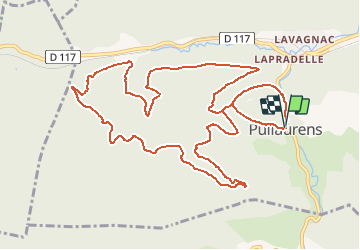
Trail Walking of 14.3 km to be discovered at Occitania, Aude. This trail is proposed by 7217Lionel.
Description
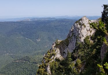
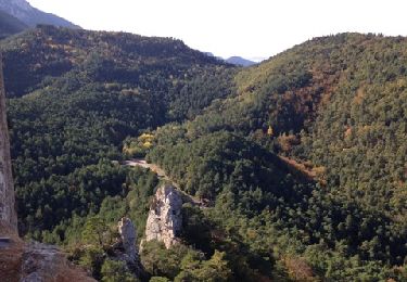
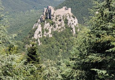
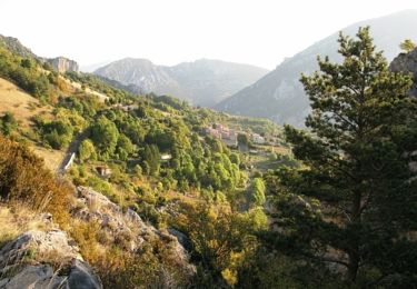
Ce circuit forestier par la Serre des Aiguilles offre des points de vue inhabituels et sans cesse renouvelés sur le château de Puilaurens (prévoir 1h15 pour la visite)
Parking: Place de la mairie.
Difficultés: longue montée entre Puilaurens et la Serre des Aiguilles.
Positioning
Country:
France
Region :
Occitania
Department/Province :
Aude
Municipality :
PUILAURENS
Location:
Unknown
Start:(Dec)
Start:(UTM)
443138 ; 4738947 (31T) N.
Comments
Trails nearby
![Trail Walking Salvezines - Forêt d’enmalo - Photo](https://media.geolcdn.com/t/375/260/3d5b7a12-6636-404a-b4ba-4e35f01380d7.jpg&format=jpg&maxdim=2)
![Walking Walking](https://static1.geolcdn.com/sitytour/trail-icons/101.png)
Forêt d’enmalo
Walking
Difficult
Salvezines,
Occitania,
Aude,
France
![](/images/other/stat-length.png)
10.1 km | 16.9 km-effort
3h 24min
![](https://static1.geolcdn.com/siteimages/upload/files/16400158638029165_repeat_loop_refresh_sync_direction_icon.png)
Yes
![Trail Walking Salvezines - Le Caunil. Maison forestière par Puylaurens - Photo](https://media.geolcdn.com/t/375/260/0670c55c-3c8e-4610-9ce9-a097762067b5.jpg&format=jpg&maxdim=2)
![Walking Walking](https://static1.geolcdn.com/sitytour/trail-icons/101.png)
Le Caunil. Maison forestière par Puylaurens
Walking
Difficult
Salvezines,
Occitania,
Aude,
France
![](/images/other/stat-length.png)
10 km | 16.2 km-effort
2h 45min
![](https://static1.geolcdn.com/siteimages/upload/files/16400158638029165_repeat_loop_refresh_sync_direction_icon.png)
Yes
![Trail Walking Salvezines - La forêt d en Malo depuis le Caunil (11) - Photo](https://media.geolcdn.com/t/375/260/ext.jpg?maxdim=2&url=https%3A%2F%2Fservices.sitytrail.com%2FGeolivesWS%2FDownloadMedia.ashx%3FTrailID%3D1035464%26Media%3Dfix__20180828120756.jpg)
![Walking Walking](https://static1.geolcdn.com/sitytour/trail-icons/101.png)
La forêt d en Malo depuis le Caunil (11)
Walking
Medium
(1)
Salvezines,
Occitania,
Aude,
France
![](/images/other/stat-length.png)
13.2 km | 22 km-effort
5h 22min
![](https://static1.geolcdn.com/siteimages/upload/files/16400158638029165_repeat_loop_refresh_sync_direction_icon.png)
Yes
![Trail Walking - Puilaurens Chateau - Photo](https://media.geolcdn.com/t/375/260/ext.jpg?maxdim=2&url=https%3A%2F%2Fservices.sitytrail.com%2FGeolivesWS%2FDownloadMedia.ashx%3FTrailID%3D231382%26Media%3D20131107141742.jpg)
![Walking Walking](https://static1.geolcdn.com/sitytour/trail-icons/101.png)
![Trail Walking Axat - axat château de puylaurens - Photo](https://media.geolcdn.com/t/375/260/69973761-a521-4826-9a30-dd2c549362c5.jpg&format=jpg&maxdim=2)
![Walking Walking](https://static1.geolcdn.com/sitytour/trail-icons/101.png)
axat château de puylaurens
Walking
Easy
Axat,
Occitania,
Aude,
France
![](/images/other/stat-length.png)
22 km | 33 km-effort
6h 27min
![](https://static1.geolcdn.com/siteimages/upload/files/16400158638029165_repeat_loop_refresh_sync_direction_icon.png)
Yes
![Trail Walking Salvezines - Autour du Pic d'Estable - Salvezine - Photo](https://media.geolcdn.com/t/375/260/ext.jpg?maxdim=2&url=https%3A%2F%2Fservices.sitytrail.com%2FGeolivesWS%2FDownloadMedia.ashx%3FTrailID%3D109699%26Media%3D4390_1.jpg)
![Walking Walking](https://static1.geolcdn.com/sitytour/trail-icons/101.png)
Autour du Pic d'Estable - Salvezine
Walking
Difficult
Salvezines,
Occitania,
Aude,
France
![](/images/other/stat-length.png)
16.1 km | 27 km-effort
5h 30min
![](https://static1.geolcdn.com/siteimages/upload/files/16400158638029165_repeat_loop_refresh_sync_direction_icon.png)
Yes
![Trail Walking Puilaurens - château de Puilaurens - Photo](https://media.geolcdn.com/t/375/260/ext.jpg?maxdim=2&url=https%3A%2F%2Fstatic1.geolcdn.com%2Fsiteimages%2Fupload%2Ffiles%2F1553511878bg_sport_marche.png)
![Walking Walking](https://static1.geolcdn.com/sitytour/trail-icons/101.png)
château de Puilaurens
Walking
Very easy
Puilaurens,
Occitania,
Aude,
France
![](/images/other/stat-length.png)
13.7 km | 21 km-effort
4h 40min
![](https://static1.geolcdn.com/siteimages/upload/files/16400158638029165_repeat_loop_refresh_sync_direction_icon.png)
Yes
![Trail Walking Puilaurens - 11_Aigues Bonnes_Quirbajou_J4 - Photo](https://media.geolcdn.com/t/375/260/ext.jpg?maxdim=2&url=https%3A%2F%2Fstatic1.geolcdn.com%2Fsiteimages%2Fupload%2Ffiles%2F1553511878bg_sport_marche.png)
![Walking Walking](https://static1.geolcdn.com/sitytour/trail-icons/101.png)
11_Aigues Bonnes_Quirbajou_J4
Walking
Difficult
Puilaurens,
Occitania,
Aude,
France
![](/images/other/stat-length.png)
26 km | 39 km-effort
9h 51min
![](https://static1.geolcdn.com/siteimages/upload/files/16400158638029165_repeat_loop_refresh_sync_direction_icon.png)
No
![Trail Walking Puilaurens - Cathares E6 Puilaurens - Prugnanes 07.06.2019 - Photo](https://media.geolcdn.com/t/375/260/ext.jpg?maxdim=2&url=https%3A%2F%2Fstatic1.geolcdn.com%2Fsiteimages%2Fupload%2Ffiles%2F1553511878bg_sport_marche.png)
![Walking Walking](https://static1.geolcdn.com/sitytour/trail-icons/101.png)
Cathares E6 Puilaurens - Prugnanes 07.06.2019
Walking
Difficult
Puilaurens,
Occitania,
Aude,
France
![](/images/other/stat-length.png)
25 km | 36 km-effort
7h 30min
![](https://static1.geolcdn.com/siteimages/upload/files/16400158638029165_repeat_loop_refresh_sync_direction_icon.png)
No