![](/images/other/stat-length.png)
![Trail Walking Port-la-Nouvelle - L'île Sainte-Lucie - Photo](https://media.geolcdn.com/t/1900/400/ext.pjpeg?maxdim=2&url=https%3A%2F%2Fstatic1.geolcdn.com%2Fsiteimages%2Fupload%2Ffiles%2F1553511878bg_sport_marche.png)
L'île Sainte-Lucie
7217Lionel
User
![Length](/images/other/stat-length.png)
Length
6.6 km
![Max alt](https://static1.geolcdn.com/siteimages/upload/files/1508320355ic_sort_altitude_max_24dp.png)
Max alt
40 m
![Uphill gradient](https://static1.geolcdn.com/siteimages/upload/files/1508320355ic_sort_den_pos_24dp.png)
Uphill gradient
50 m
![Km-Effort](/images/other/stat-length.png)
Km-Effort
7.2 km
![Min alt](https://static1.geolcdn.com/siteimages/upload/files/1508320355ic_sort_altitude_min_24dp.png)
Min alt
4 m
![Downhill gradient](https://static1.geolcdn.com/siteimages/upload/files/1508320355ic_sort_den_neg_24dp.png)
Downhill gradient
51 m
![Boucle](https://static1.geolcdn.com/siteimages/upload/files/16400158638029165_repeat_loop_refresh_sync_direction_icon.png)
Boucle
Yes
Creation date :
2015-07-02 00:00:00.0
Updated on :
2015-07-02 00:00:00.0
![Walking](https://static1.geolcdn.com/sitytour/trail-icons/101.png)
1h40
Difficulty : Very easy
![Scan this QR Code to open this trail in the SityTrail application](https://capi.geolives.com/qq0zvz2zws4bq2lad0pu/sitytour/trails/440463/qr.png?size=200)
FREE GPS app for hiking
About
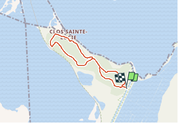
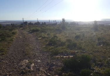
Trail Walking of 6.6 km to be discovered at Occitania, Aude, Port-la-Nouvelle. This trail is proposed by 7217Lionel.
Description
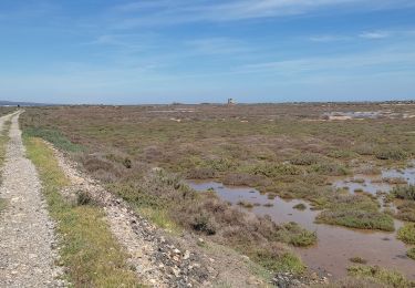
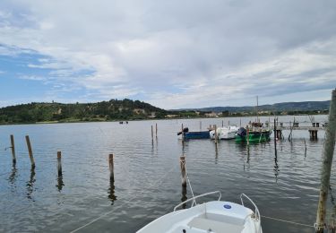
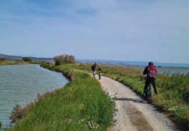
Entre mer, étangs et canal, cette petite promenade, accessible à tous, se déroule à travers une végétation méditerranéenne parfaitement préservée.
Positioning
Country:
France
Region :
Occitania
Department/Province :
Aude
Municipality :
Port-la-Nouvelle
Location:
Unknown
Start:(Dec)
Start:(UTM)
504505 ; 4766100 (31T) N.
Comments
Trails nearby
![Trail Walking Port-la-Nouvelle - Port la nouvelle - Photo](https://media.geolcdn.com/t/375/260/b6313dc6-a7e0-4f0e-bceb-1493c2dc6087.jpg&format=jpg&maxdim=2)
![Walking Walking](https://static1.geolcdn.com/sitytour/trail-icons/101.png)
Port la nouvelle
Walking
Easy
Port-la-Nouvelle,
Occitania,
Aude,
France
![](/images/other/stat-length.png)
11.9 km | 13.1 km-effort
4h 58min
![](https://static1.geolcdn.com/siteimages/upload/files/16400158638029165_repeat_loop_refresh_sync_direction_icon.png)
Yes
![Trail Walking Port-la-Nouvelle - Port la nouvelle - Photo](https://media.geolcdn.com/t/375/260/4650213f-f303-4d9e-b2fa-13ce36bb8422.jpg&format=jpg&maxdim=2)
![Walking Walking](https://static1.geolcdn.com/sitytour/trail-icons/101.png)
Port la nouvelle
Walking
Easy
Port-la-Nouvelle,
Occitania,
Aude,
France
![](/images/other/stat-length.png)
13.4 km | 14.7 km-effort
3h 29min
![](https://static1.geolcdn.com/siteimages/upload/files/16400158638029165_repeat_loop_refresh_sync_direction_icon.png)
Yes
![Trail Mountain bike Port-la-Nouvelle - Boucle de Bages d Aude - Photo](https://media.geolcdn.com/t/375/260/a01030c1-d4b4-447f-a4d0-03c1eec8e654.jpg&format=jpg&maxdim=2)
![Mountain bike Mountain bike](https://static1.geolcdn.com/sitytour/trail-icons/202.png)
Boucle de Bages d Aude
Mountain bike
Medium
Port-la-Nouvelle,
Occitania,
Aude,
France
![](/images/other/stat-length.png)
67 km | 72 km-effort
Unknown
![](https://static1.geolcdn.com/siteimages/upload/files/16400158638029165_repeat_loop_refresh_sync_direction_icon.png)
Yes
![Trail Mountain bike Port-la-Nouvelle - Port la Nouvelle ( parking île Ste Lucie ) Bages d 'Aude - Photo](https://media.geolcdn.com/t/375/260/5bfa458c-6110-4868-b219-6b44500d4cf8.jpg&format=jpg&maxdim=2)
![Mountain bike Mountain bike](https://static1.geolcdn.com/sitytour/trail-icons/202.png)
Port la Nouvelle ( parking île Ste Lucie ) Bages d 'Aude
Mountain bike
Very difficult
Port-la-Nouvelle,
Occitania,
Aude,
France
![](/images/other/stat-length.png)
65 km | 70 km-effort
6h 32min
![](https://static1.geolcdn.com/siteimages/upload/files/16400158638029165_repeat_loop_refresh_sync_direction_icon.png)
Yes
![Trail Donkey back riding Port-la-Nouvelle - Cathare 1 port la nouvelle Durban Corbieres - Photo](https://media.geolcdn.com/t/375/260/e41ebe21-8688-4101-9289-802a8715a742.jpg&format=jpg&maxdim=2)
![Donkey back riding Donkey back riding](https://static1.geolcdn.com/sitytour/trail-icons/303.png)
Cathare 1 port la nouvelle Durban Corbieres
Donkey back riding
Medium
Port-la-Nouvelle,
Occitania,
Aude,
France
![](/images/other/stat-length.png)
20 km | 26 km-effort
4h 21min
![](https://static1.geolcdn.com/siteimages/upload/files/16400158638029165_repeat_loop_refresh_sync_direction_icon.png)
No
![Trail Walking Gruissan - 2017-ES-SPLM-Sentier_des_Goules-5,8km - Photo](https://media.geolcdn.com/t/375/260/ext.jpg?maxdim=2&url=https%3A%2F%2Fstatic1.geolcdn.com%2Fsiteimages%2Fupload%2Ffiles%2F1553511878bg_sport_marche.png)
![Walking Walking](https://static1.geolcdn.com/sitytour/trail-icons/101.png)
2017-ES-SPLM-Sentier_des_Goules-5,8km
Walking
Easy
(1)
Gruissan,
Occitania,
Aude,
France
![](/images/other/stat-length.png)
5.8 km | 6.7 km-effort
1h 31min
![](https://static1.geolcdn.com/siteimages/upload/files/16400158638029165_repeat_loop_refresh_sync_direction_icon.png)
Yes
![Trail Mountain bike Port-la-Nouvelle - ste lucie gruissan vtt - Photo](https://media.geolcdn.com/t/375/260/ext.jpg?maxdim=2&url=https%3A%2F%2Fstatic1.geolcdn.com%2Fsiteimages%2Fupload%2Ffiles%2F1524743154velo.jpg)
![Mountain bike Mountain bike](https://static1.geolcdn.com/sitytour/trail-icons/202.png)
ste lucie gruissan vtt
Mountain bike
Easy
(2)
Port-la-Nouvelle,
Occitania,
Aude,
France
![](/images/other/stat-length.png)
34 km | 36 km-effort
2h 24min
![](https://static1.geolcdn.com/siteimages/upload/files/16400158638029165_repeat_loop_refresh_sync_direction_icon.png)
Yes
![Trail Walking Port-la-Nouvelle - Sentier Cathare - Photo](https://media.geolcdn.com/t/375/260/ext.jpg?maxdim=2&url=https%3A%2F%2Fstatic1.geolcdn.com%2Fsiteimages%2Fupload%2Ffiles%2F1553511878bg_sport_marche.png)
![Walking Walking](https://static1.geolcdn.com/sitytour/trail-icons/101.png)
Sentier Cathare
Walking
Medium
(2)
Port-la-Nouvelle,
Occitania,
Aude,
France
![](/images/other/stat-length.png)
360 km | 572 km-effort
Unknown
![](https://static1.geolcdn.com/siteimages/upload/files/16400158638029165_repeat_loop_refresh_sync_direction_icon.png)
No
![Trail Walking Gruissan - Le Belvédère de Gruissan - Photo](https://media.geolcdn.com/t/375/260/ext.jpg?maxdim=2&url=https%3A%2F%2Fservices.sitytrail.com%2FGeolivesWS%2FDownloadMedia.ashx%3FTrailID%3D109652%26Media%3D4293_5.jpg)
![Walking Walking](https://static1.geolcdn.com/sitytour/trail-icons/101.png)
Le Belvédère de Gruissan
Walking
Easy
Gruissan,
Occitania,
Aude,
France
![](/images/other/stat-length.png)
4.5 km | 5.8 km-effort
2h 10min
![](https://static1.geolcdn.com/siteimages/upload/files/16400158638029165_repeat_loop_refresh_sync_direction_icon.png)
Yes