![](/images/other/stat-length.png)
![Trail Walking Pompey - Pompey, forêt de l'Avant Garde - Photo](https://media.geolcdn.com/t/1900/400/ext.pjpeg?maxdim=2&url=https%3A%2F%2Fstatic1.geolcdn.com%2Fsiteimages%2Fupload%2Ffiles%2F1553511878bg_sport_marche.png)
Pompey, forêt de l'Avant Garde
joelclaudel
User
![Length](/images/other/stat-length.png)
Length
11.2 km
![Max alt](https://static1.geolcdn.com/siteimages/upload/files/1508320355ic_sort_altitude_max_24dp.png)
Max alt
363 m
![Uphill gradient](https://static1.geolcdn.com/siteimages/upload/files/1508320355ic_sort_den_pos_24dp.png)
Uphill gradient
189 m
![Km-Effort](/images/other/stat-length.png)
Km-Effort
13.7 km
![Min alt](https://static1.geolcdn.com/siteimages/upload/files/1508320355ic_sort_altitude_min_24dp.png)
Min alt
293 m
![Downhill gradient](https://static1.geolcdn.com/siteimages/upload/files/1508320355ic_sort_den_neg_24dp.png)
Downhill gradient
183 m
![Boucle](https://static1.geolcdn.com/siteimages/upload/files/16400158638029165_repeat_loop_refresh_sync_direction_icon.png)
Boucle
Yes
Creation date :
2015-07-02 00:00:00.0
Updated on :
2015-07-02 00:00:00.0
![Walking](https://static1.geolcdn.com/sitytour/trail-icons/101.png)
2h58
Difficulty : Easy
![Scan this QR Code to open this trail in the SityTrail application](https://capi.geolives.com/qq0zvz2zws4bq2lad0pu/sitytour/trails/439763/qr.png?size=200)
FREE GPS app for hiking
About
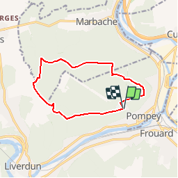
Trail Walking of 11.2 km to be discovered at Grand Est, Meurthe-et-Moselle, Pompey. This trail is proposed by joelclaudel.
Description
Départ parking du parcours acrobatique de Fort Aventure, plateau de l'Avant Garde à Pompey
Balisage triangle jaune (il faut parfois le chercher...)
Parcours principalement en forêt
Positioning
Country:
France
Region :
Grand Est
Department/Province :
Meurthe-et-Moselle
Municipality :
Pompey
Location:
Unknown
Start:(Dec)
Start:(UTM)
287886 ; 5405707 (32U) N.
Comments
Trails nearby
![Trail On foot Champigneulles - Circuit G - Photo](https://media.geolcdn.com/t/375/260/367653e8-319c-4965-be92-65937a99215e.jpeg&format=jpg&maxdim=2)
![On foot On foot](https://static1.geolcdn.com/sitytour/trail-icons/100.png)
Circuit G
On foot
Medium
Champigneulles,
Grand Est,
Meurthe-et-Moselle,
France
![](/images/other/stat-length.png)
18.7 km | 24 km-effort
5h 24min
![](https://static1.geolcdn.com/siteimages/upload/files/16400158638029165_repeat_loop_refresh_sync_direction_icon.png)
No
![Trail On foot Champigneulles - Circuit du Val Saint-Barthélémy - Photo](https://media.geolcdn.com/t/375/260/199ee8e6-f9b7-4be8-9188-093275697409.jpeg&format=jpg&maxdim=2)
![On foot On foot](https://static1.geolcdn.com/sitytour/trail-icons/100.png)
Circuit du Val Saint-Barthélémy
On foot
Easy
Champigneulles,
Grand Est,
Meurthe-et-Moselle,
France
![](/images/other/stat-length.png)
7 km | 8.6 km-effort
1h 57min
![](https://static1.geolcdn.com/siteimages/upload/files/16400158638029165_repeat_loop_refresh_sync_direction_icon.png)
Yes
![Trail Walking Liverdun - Liverdun - La grande boucle de Natrou - Photo](https://media.geolcdn.com/t/375/260/5dac390e-3606-42c9-8130-3aab112c0eaf.jpg&format=jpg&maxdim=2)
![Walking Walking](https://static1.geolcdn.com/sitytour/trail-icons/101.png)
Liverdun - La grande boucle de Natrou
Walking
Medium
Liverdun,
Grand Est,
Meurthe-et-Moselle,
France
![](/images/other/stat-length.png)
11.1 km | 13.5 km-effort
3h 2min
![](https://static1.geolcdn.com/siteimages/upload/files/16400158638029165_repeat_loop_refresh_sync_direction_icon.png)
Yes
![Trail Bicycle tourism Frouard - 4ème rando vélo Frouard - Lagarde 62 km - Photo](https://media.geolcdn.com/t/375/260/13993c5f-3965-404c-880f-e186b1a79db8.jpg&format=jpg&maxdim=2)
![Bicycle tourism Bicycle tourism](https://static1.geolcdn.com/sitytour/trail-icons/204.png)
4ème rando vélo Frouard - Lagarde 62 km
Bicycle tourism
Very difficult
Frouard,
Grand Est,
Meurthe-et-Moselle,
France
![](/images/other/stat-length.png)
62 km | 67 km-effort
4h 32min
![](https://static1.geolcdn.com/siteimages/upload/files/16400158638029165_repeat_loop_refresh_sync_direction_icon.png)
No
![Trail On foot Liverdun - Circuit H - Photo](https://media.geolcdn.com/t/375/260/0a326646-0027-4e90-97f9-294cb38ae070.jpeg&format=jpg&maxdim=2)
![On foot On foot](https://static1.geolcdn.com/sitytour/trail-icons/100.png)
Circuit H
On foot
Easy
Liverdun,
Grand Est,
Meurthe-et-Moselle,
France
![](/images/other/stat-length.png)
10.2 km | 12.5 km-effort
2h 50min
![](https://static1.geolcdn.com/siteimages/upload/files/16400158638029165_repeat_loop_refresh_sync_direction_icon.png)
Yes
![Trail On foot Champigneulles - Circuit G : Circuit principal - Photo](https://media.geolcdn.com/t/375/260/367653e8-319c-4965-be92-65937a99215e.jpeg&format=jpg&maxdim=2)
![On foot On foot](https://static1.geolcdn.com/sitytour/trail-icons/100.png)
Circuit G : Circuit principal
On foot
Easy
Champigneulles,
Grand Est,
Meurthe-et-Moselle,
France
![](/images/other/stat-length.png)
8.4 km | 11.1 km-effort
2h 31min
![](https://static1.geolcdn.com/siteimages/upload/files/16400158638029165_repeat_loop_refresh_sync_direction_icon.png)
No
![Trail On foot Champigneulles - Circuit du Vallum de la Fourasse - Photo](https://media.geolcdn.com/t/375/260/ff5ef522-89ca-4a55-89a5-b4737ce72d51.jpeg&format=jpg&maxdim=2)
![On foot On foot](https://static1.geolcdn.com/sitytour/trail-icons/100.png)
Circuit du Vallum de la Fourasse
On foot
Easy
Champigneulles,
Grand Est,
Meurthe-et-Moselle,
France
![](/images/other/stat-length.png)
3.3 km | 4.9 km-effort
1h 6min
![](https://static1.geolcdn.com/siteimages/upload/files/16400158638029165_repeat_loop_refresh_sync_direction_icon.png)
Yes
![Trail On foot Marbache - Circuit de la Vierge de Belleville - Photo](https://media.geolcdn.com/t/375/260/ed731c2b-3434-456a-907f-b6c3a07468bd.jpeg&format=jpg&maxdim=2)
![On foot On foot](https://static1.geolcdn.com/sitytour/trail-icons/100.png)
Circuit de la Vierge de Belleville
On foot
Easy
Marbache,
Grand Est,
Meurthe-et-Moselle,
France
![](/images/other/stat-length.png)
6 km | 8.5 km-effort
1h 55min
![](https://static1.geolcdn.com/siteimages/upload/files/16400158638029165_repeat_loop_refresh_sync_direction_icon.png)
Yes
![Trail On foot Bouxières-aux-Dames - Circuit moyenne ceinture - Photo](https://media.geolcdn.com/t/375/260/88bdd629-0aa3-4fce-b286-82104b98c415.jpeg&format=jpg&maxdim=2)
![On foot On foot](https://static1.geolcdn.com/sitytour/trail-icons/100.png)
Circuit moyenne ceinture
On foot
Easy
Bouxières-aux-Dames,
Grand Est,
Meurthe-et-Moselle,
France
![](/images/other/stat-length.png)
3.8 km | 5.3 km-effort
1h 12min
![](https://static1.geolcdn.com/siteimages/upload/files/16400158638029165_repeat_loop_refresh_sync_direction_icon.png)
Yes