![](/images/other/stat-length.png)
![Trail Walking Mijoux - faucille-reculet - Photo](https://media.geolcdn.com/t/1900/400/ext.pjpeg?maxdim=2&url=https%3A%2F%2Fstatic1.geolcdn.com%2Fsiteimages%2Fupload%2Ffiles%2F1553511878bg_sport_marche.png)
faucille-reculet
MartinDussaux
User
![Length](/images/other/stat-length.png)
Length
26 km
![Max alt](https://static1.geolcdn.com/siteimages/upload/files/1508320355ic_sort_altitude_max_24dp.png)
Max alt
1710 m
![Uphill gradient](https://static1.geolcdn.com/siteimages/upload/files/1508320355ic_sort_den_pos_24dp.png)
Uphill gradient
1021 m
![Km-Effort](/images/other/stat-length.png)
Km-Effort
41 km
![Min alt](https://static1.geolcdn.com/siteimages/upload/files/1508320355ic_sort_altitude_min_24dp.png)
Min alt
842 m
![Downhill gradient](https://static1.geolcdn.com/siteimages/upload/files/1508320355ic_sort_den_neg_24dp.png)
Downhill gradient
1449 m
![Boucle](https://static1.geolcdn.com/siteimages/upload/files/16400158638029165_repeat_loop_refresh_sync_direction_icon.png)
Boucle
No
Creation date :
2015-06-29 00:00:00.0
Updated on :
2015-06-29 00:00:00.0
![Walking](https://static1.geolcdn.com/sitytour/trail-icons/101.png)
7h13
Difficulty : Difficult
![Scan this QR Code to open this trail in the SityTrail application](https://capi.geolives.com/qq0zvz2zws4bq2lad0pu/sitytour/trails/439483/qr.png?size=200)
FREE GPS app for hiking
About
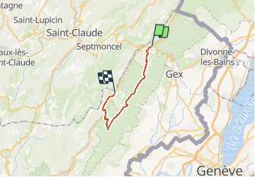
Trail Walking of 26 km to be discovered at Auvergne-Rhône-Alpes, Ain, Mijoux. This trail is proposed by MartinDussaux.
Description
depart parking de la faucille. petit et grand mont rond, colomby, monthoisey, grand crêt, crêt de la neige, reculet.
arrivée parking de lelex
Positioning
Country:
France
Region :
Auvergne-Rhône-Alpes
Department/Province :
Ain
Municipality :
Mijoux
Location:
Unknown
Start:(Dec)
Start:(UTM)
270360 ; 5139164 (32T) N.
Comments
Trails nearby
![Trail Walking Lamoura - Tresberruy - Lamoura - Photo](https://media.geolcdn.com/t/375/260/ext.jpg?maxdim=2&url=https%3A%2F%2Fservices.sitytrail.com%2FGeolivesWS%2FDownloadMedia.ashx%3FTrailID%3D191503%26Media%3D15097_5.jpg)
![Walking Walking](https://static1.geolcdn.com/sitytour/trail-icons/101.png)
Tresberruy - Lamoura
Walking
Difficult
(1)
Lamoura,
Bourgogne-Franche-Comté,
Jura,
France
![](/images/other/stat-length.png)
14.5 km | 20 km-effort
4h 0min
![](https://static1.geolcdn.com/siteimages/upload/files/16400158638029165_repeat_loop_refresh_sync_direction_icon.png)
Yes
![Trail Cycle Lajoux - 2023-08-18_15h23m20_lamoura - Photo](https://media.geolcdn.com/t/375/260/ext.jpg?maxdim=2&url=https%3A%2F%2Fstatic1.geolcdn.com%2Fsiteimages%2Fupload%2Ffiles%2F1524743154velo.jpg)
![Cycle Cycle](https://static1.geolcdn.com/sitytour/trail-icons/200.png)
2023-08-18_15h23m20_lamoura
Cycle
Very easy
(1)
Lajoux,
Bourgogne-Franche-Comté,
Jura,
France
![](/images/other/stat-length.png)
21 km | 26 km-effort
Unknown
![](https://static1.geolcdn.com/siteimages/upload/files/16400158638029165_repeat_loop_refresh_sync_direction_icon.png)
Yes
![Trail Running Mijoux - UTTJ 2015-2 - Photo](https://media.geolcdn.com/t/375/260/ext.jpg?maxdim=2&url=https%3A%2F%2Fstatic1.geolcdn.com%2Fsiteimages%2Fupload%2Ffiles%2F1524743154running.jpg)
![Running Running](https://static1.geolcdn.com/sitytour/trail-icons/103.png)
UTTJ 2015-2
Running
Very difficult
(1)
Mijoux,
Auvergne-Rhône-Alpes,
Ain,
France
![](/images/other/stat-length.png)
57 km | 92 km-effort
18h 13min
![](https://static1.geolcdn.com/siteimages/upload/files/16400158638029165_repeat_loop_refresh_sync_direction_icon.png)
No
![Trail Walking Lamoura - lamoura neige et plein air - Photo](https://media.geolcdn.com/t/375/260/79eb4e53-0429-41e7-9bcb-cf15e9d8ead1.jpg&format=jpg&maxdim=2)
![Walking Walking](https://static1.geolcdn.com/sitytour/trail-icons/101.png)
lamoura neige et plein air
Walking
Difficult
Lamoura,
Bourgogne-Franche-Comté,
Jura,
France
![](/images/other/stat-length.png)
6.8 km | 9.5 km-effort
2h 25min
![](https://static1.geolcdn.com/siteimages/upload/files/16400158638029165_repeat_loop_refresh_sync_direction_icon.png)
Yes
![Trail Walking Lamoura - neige et plein air lamoura - Photo](https://media.geolcdn.com/t/375/260/0b5e943d-bb9b-41cd-9490-d26e61edcd49.jpg&format=jpg&maxdim=2)
![Walking Walking](https://static1.geolcdn.com/sitytour/trail-icons/101.png)
neige et plein air lamoura
Walking
Medium
Lamoura,
Bourgogne-Franche-Comté,
Jura,
France
![](/images/other/stat-length.png)
6.8 km | 9.3 km-effort
2h 54min
![](https://static1.geolcdn.com/siteimages/upload/files/16400158638029165_repeat_loop_refresh_sync_direction_icon.png)
Yes
![Trail Walking Lajoux - Le crêt de la vigoureuse (le vrai) - Photo](https://media.geolcdn.com/t/375/260/5ee095a6-7dfc-4756-a886-0e730cf92336.jpg&format=jpg&maxdim=2)
![Walking Walking](https://static1.geolcdn.com/sitytour/trail-icons/101.png)
Le crêt de la vigoureuse (le vrai)
Walking
Easy
Lajoux,
Bourgogne-Franche-Comté,
Jura,
France
![](/images/other/stat-length.png)
10.4 km | 13.4 km-effort
4h 9min
![](https://static1.geolcdn.com/siteimages/upload/files/16400158638029165_repeat_loop_refresh_sync_direction_icon.png)
Yes
![Trail Walking Lajoux - crêt vigoureuse - Photo](https://media.geolcdn.com/t/375/260/621ceada-b70a-4736-ab71-b2ed77e63872.jpg&format=jpg&maxdim=2)
![Walking Walking](https://static1.geolcdn.com/sitytour/trail-icons/101.png)
crêt vigoureuse
Walking
Medium
Lajoux,
Bourgogne-Franche-Comté,
Jura,
France
![](/images/other/stat-length.png)
12.3 km | 16.8 km-effort
5h 0min
![](https://static1.geolcdn.com/siteimages/upload/files/16400158638029165_repeat_loop_refresh_sync_direction_icon.png)
Yes
![Trail Walking Gex - Balade à Col de la Faucille, Gex - Photo](https://media.geolcdn.com/t/375/260/2f44fa08-e5b7-4e3a-aeb8-a26203de0478.jpg&format=jpg&maxdim=2)
![Walking Walking](https://static1.geolcdn.com/sitytour/trail-icons/101.png)
Balade à Col de la Faucille, Gex
Walking
Very difficult
Gex,
Auvergne-Rhône-Alpes,
Ain,
France
![](/images/other/stat-length.png)
86 km | 135 km-effort
9h 23min
![](https://static1.geolcdn.com/siteimages/upload/files/16400158638029165_repeat_loop_refresh_sync_direction_icon.png)
No
![Trail Bicycle tourism Mijoux - LES ROUSSES - COL DE LA FAUCILLE - Photo](https://media.geolcdn.com/t/375/260/8bcbda14-9a90-4870-91bc-b4b02ae26659.jpg&format=jpg&maxdim=2)
![Bicycle tourism Bicycle tourism](https://static1.geolcdn.com/sitytour/trail-icons/204.png)
LES ROUSSES - COL DE LA FAUCILLE
Bicycle tourism
Very difficult
Mijoux,
Auvergne-Rhône-Alpes,
Ain,
France
![](/images/other/stat-length.png)
54 km | 68 km-effort
4h 57min
![](https://static1.geolcdn.com/siteimages/upload/files/16400158638029165_repeat_loop_refresh_sync_direction_icon.png)
No