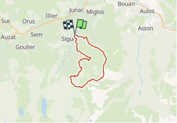
![](/images/other/stat-length.png)
![Trail Running Gestiès - TRAIL-Pla de Montcamp - Photo](https://media.geolcdn.com/t/1900/400/ext.pjpeg?maxdim=2&url=https%3A%2F%2Fstatic1.geolcdn.com%2Fsiteimages%2Fupload%2Ffiles%2F1524743154running.jpg)
TRAIL-Pla de Montcamp
Polo-31
User
![Length](/images/other/stat-length.png)
![Max alt](https://static1.geolcdn.com/siteimages/upload/files/1508320355ic_sort_altitude_max_24dp.png)
![Uphill gradient](https://static1.geolcdn.com/siteimages/upload/files/1508320355ic_sort_den_pos_24dp.png)
![Km-Effort](/images/other/stat-length.png)
![Min alt](https://static1.geolcdn.com/siteimages/upload/files/1508320355ic_sort_altitude_min_24dp.png)
![Downhill gradient](https://static1.geolcdn.com/siteimages/upload/files/1508320355ic_sort_den_neg_24dp.png)
![Boucle](https://static1.geolcdn.com/siteimages/upload/files/16400158638029165_repeat_loop_refresh_sync_direction_icon.png)
![Running](https://static1.geolcdn.com/sitytour/trail-icons/103.png)
6h00
Difficulty : Medium
![Scan this QR Code to open this trail in the SityTrail application](https://capi.geolives.com/qq0zvz2zws4bq2lad0pu/sitytour/trails/436681/qr.png?size=200)
FREE GPS app for hiking
About
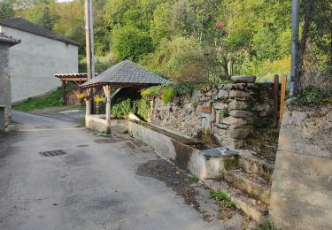
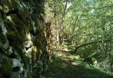
Trail Running of 22 km to be discovered at Occitania, Ariège, Gestiès. This trail is proposed by Polo-31.
Description
Depuis GESTIE, suivre le GR10 jusqu'au Pla de MONTCAMP puis suivre les crêtes par Col du Sasc, Pic du Col Taillat, Cap de Serre de l'Escalier, La Calbe, le Pic de Baljésou (Un chemin contourne sans passer par le sommet), Pic du Midi de Siguer. Attention à passer après le pic par le petit lac, jasse d'Oustenac et rejoindre directement par la droite proche du ruisseau la jasse de Peyriguels (Le chemin tracé sur la carte par la crête et la descente vers la jasse de Peyriguels n'existe plus, la descente du point 1681 au 1606 est très compliquée, hors sentier difficile) après suivre le sentier bien évident et rentrer par la route forestière du Debes.
Positioning
Comments
Trails nearby
![Trail Electric bike Niaux - Château Miglos - Photo](https://media.geolcdn.com/t/375/260/8bba2701-86a9-409d-bc1b-998f1da97a1d.jpg&format=jpg&maxdim=2)
![Electric bike Electric bike](https://static1.geolcdn.com/sitytour/trail-icons/205.png)
Electric bike
![](/images/other/stat-length.png)
![](https://static1.geolcdn.com/siteimages/upload/files/16400158638029165_repeat_loop_refresh_sync_direction_icon.png)
![Trail On foot Lapège - Lapège et Pladetis - Photo](https://media.geolcdn.com/t/375/260/acf32a31-72a6-4e31-a909-32a8fa5a01b2.jpeg&format=jpg&maxdim=2)
![On foot On foot](https://static1.geolcdn.com/sitytour/trail-icons/100.png)
On foot
![](/images/other/stat-length.png)
![](https://static1.geolcdn.com/siteimages/upload/files/16400158638029165_repeat_loop_refresh_sync_direction_icon.png)
![Trail On foot Val-de-Sos - Le Palet de Samsom - Photo](https://media.geolcdn.com/t/375/260/3f092e96-c063-46a3-9421-f94e65e3f3dd.jpeg&format=jpg&maxdim=2)
![On foot On foot](https://static1.geolcdn.com/sitytour/trail-icons/100.png)
On foot
![](/images/other/stat-length.png)
![](https://static1.geolcdn.com/siteimages/upload/files/16400158638029165_repeat_loop_refresh_sync_direction_icon.png)
![Trail On foot Illier-et-Laramade - D'Illier à Lapège - Photo](https://media.geolcdn.com/t/375/260/467a3965-d36a-44de-94c6-d7883cfb171b.jpeg&format=jpg&maxdim=2)
![On foot On foot](https://static1.geolcdn.com/sitytour/trail-icons/100.png)
On foot
![](/images/other/stat-length.png)
![](https://static1.geolcdn.com/siteimages/upload/files/16400158638029165_repeat_loop_refresh_sync_direction_icon.png)
![Trail Walking Lercoul - 2021-09-19_20h11m54_Pic-de-garbie-de-bresoul-depuis-lercoul-19x09x2021 - Photo](https://media.geolcdn.com/t/375/260/82f09742-d952-478c-ab3a-a2125788a8a9.jpg&format=jpg&maxdim=2)
![Walking Walking](https://static1.geolcdn.com/sitytour/trail-icons/101.png)
Walking
![](/images/other/stat-length.png)
![](https://static1.geolcdn.com/siteimages/upload/files/16400158638029165_repeat_loop_refresh_sync_direction_icon.png)
![Trail Walking Siguer - col côte 2239m - Photo](https://media.geolcdn.com/t/375/260/d0d85790-0797-4c33-ac54-27f9e26acbc3.jpg&format=jpg&maxdim=2)
![Walking Walking](https://static1.geolcdn.com/sitytour/trail-icons/101.png)
Walking
![](/images/other/stat-length.png)
![](https://static1.geolcdn.com/siteimages/upload/files/16400158638029165_repeat_loop_refresh_sync_direction_icon.png)
![Trail Walking Miglos - rocher de MIGLOS - Photo](https://media.geolcdn.com/t/375/260/50dd3b08-cf6c-423a-9a83-85e7a8a41a23.jpg&format=jpg&maxdim=2)
![Walking Walking](https://static1.geolcdn.com/sitytour/trail-icons/101.png)
Walking
![](/images/other/stat-length.png)
![](https://static1.geolcdn.com/siteimages/upload/files/16400158638029165_repeat_loop_refresh_sync_direction_icon.png)
![Trail Walking Larnat - Cap de la Lesse - Photo](https://media.geolcdn.com/t/375/260/92ac1c0a-3485-447b-b2e9-0e186b2c8c4a.jpg&format=jpg&maxdim=2)
![Walking Walking](https://static1.geolcdn.com/sitytour/trail-icons/101.png)
![Trail Walking Capoulet-et-Junac - Le Vicdessos par Illié - Photo](https://media.geolcdn.com/t/375/260/ca761c83-3387-4b8c-a324-b7eee82e1103.jpg&format=jpg&maxdim=2)
![Walking Walking](https://static1.geolcdn.com/sitytour/trail-icons/101.png)
Walking
![](/images/other/stat-length.png)
![](https://static1.geolcdn.com/siteimages/upload/files/16400158638029165_repeat_loop_refresh_sync_direction_icon.png)