![](/images/other/stat-length.png)
![Trail Walking Riaz - Riaz - Marsens - L'Abbaye - Photo](https://media.geolcdn.com/t/1900/400/ext.pjpeg?maxdim=2&url=https%3A%2F%2Fstatic1.geolcdn.com%2Fsiteimages%2Fupload%2Ffiles%2F1553511878bg_sport_marche.png)
Riaz - Marsens - L'Abbaye
gpiller
User
![Length](/images/other/stat-length.png)
Length
8 km
![Max alt](https://static1.geolcdn.com/siteimages/upload/files/1508320355ic_sort_altitude_max_24dp.png)
Max alt
915 m
![Uphill gradient](https://static1.geolcdn.com/siteimages/upload/files/1508320355ic_sort_den_pos_24dp.png)
Uphill gradient
214 m
![Km-Effort](/images/other/stat-length.png)
Km-Effort
10.8 km
![Min alt](https://static1.geolcdn.com/siteimages/upload/files/1508320355ic_sort_altitude_min_24dp.png)
Min alt
718 m
![Downhill gradient](https://static1.geolcdn.com/siteimages/upload/files/1508320355ic_sort_den_neg_24dp.png)
Downhill gradient
214 m
![Boucle](https://static1.geolcdn.com/siteimages/upload/files/16400158638029165_repeat_loop_refresh_sync_direction_icon.png)
Boucle
Yes
Creation date :
2019-02-26 08:45:49.985
Updated on :
2019-02-26 08:45:50.014
![Walking](https://static1.geolcdn.com/sitytour/trail-icons/101.png)
2h30
Difficulty : Very easy
![Scan this QR Code to open this trail in the SityTrail application](https://capi.geolives.com/qq0zvz2zws4bq2lad0pu/sitytour/trails/435942/qr.png?size=200)
FREE GPS app for hiking
About
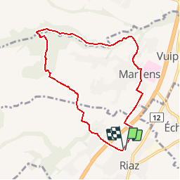
Trail Walking of 8 km to be discovered at Fribourg, Gruyère District, Riaz. This trail is proposed by gpiller.
Description
Parcours proposé par Gabriel Dematraz.
Bicubic - Riaz via A12, Parking de la grande salle. 2ème route à gauche après le giratoire de Riaz. 20.5 Km, 21min Fr. 3.00
Café de la Croix-Blance 026 9127297
Positioning
Country:
Switzerland
Region :
Fribourg
Department/Province :
Gruyère District
Municipality :
Riaz
Location:
Unknown
Start:(Dec)
Start:(UTM)
351583 ; 5167298 (32T) N.
Comments
Trails nearby
![Trail Walking Bulle - Broc FR - Notre Dame des Marches - Photo](https://media.geolcdn.com/t/375/260/ext.jpg?maxdim=2&url=https%3A%2F%2Fstatic1.geolcdn.com%2Fsiteimages%2Fupload%2Ffiles%2F1553511878bg_sport_marche.png)
![Walking Walking](https://static1.geolcdn.com/sitytour/trail-icons/101.png)
Broc FR - Notre Dame des Marches
Walking
Very easy
(1)
Bulle,
Fribourg,
Gruyère District,
Switzerland
![](/images/other/stat-length.png)
14.3 km | 19.7 km-effort
4h 37min
![](https://static1.geolcdn.com/siteimages/upload/files/16400158638029165_repeat_loop_refresh_sync_direction_icon.png)
Yes
![Trail On foot Sorens - Circuit Le Gibloux crête tour - Photo](https://media.geolcdn.com/t/375/260/45e5a679-ea50-4f19-83c0-d4c049841f82.jpeg&format=jpg&maxdim=2)
![On foot On foot](https://static1.geolcdn.com/sitytour/trail-icons/100.png)
Circuit Le Gibloux crête tour
On foot
Easy
Sorens,
Fribourg,
Gruyère District,
Switzerland
![](/images/other/stat-length.png)
4.2 km | 6.9 km-effort
1h 33min
![](https://static1.geolcdn.com/siteimages/upload/files/16400158638029165_repeat_loop_refresh_sync_direction_icon.png)
Yes
![Trail Walking Marsens - st_bg_villars2 - Photo](https://media.geolcdn.com/t/375/260/ext.jpg?maxdim=2&url=https%3A%2F%2Fstatic1.geolcdn.com%2Fsiteimages%2Fupload%2Ffiles%2F1553511878bg_sport_marche.png)
![Walking Walking](https://static1.geolcdn.com/sitytour/trail-icons/101.png)
st_bg_villars2
Walking
Very easy
Marsens,
Fribourg,
Gruyère District,
Switzerland
![](/images/other/stat-length.png)
136 km | 206 km-effort
Unknown
![](https://static1.geolcdn.com/siteimages/upload/files/16400158638029165_repeat_loop_refresh_sync_direction_icon.png)
No
![Trail Walking Broc - Gorges de la Jogne, lac de Montsalvens circuit 07.04.17 - Photo](https://media.geolcdn.com/t/375/260/ext.jpg?maxdim=2&url=https%3A%2F%2Fservices.sitytrail.com%2FGeolivesWS%2FDownloadMedia.ashx%3FTrailID%3D728333%26Media%3D6d1987d7-f8ac-4d38-94c7-1c3fdbb4f749.jpg)
![Walking Walking](https://static1.geolcdn.com/sitytour/trail-icons/101.png)
Gorges de la Jogne, lac de Montsalvens circuit 07.04.17
Walking
Medium
Broc,
Fribourg,
Gruyère District,
Switzerland
![](/images/other/stat-length.png)
12.6 km | 19 km-effort
4h 17min
![](https://static1.geolcdn.com/siteimages/upload/files/16400158638029165_repeat_loop_refresh_sync_direction_icon.png)
Yes
![Trail Walking Bulle - Bulle-Le Vissieu-Bulle - Photo](https://media.geolcdn.com/t/375/260/ext.jpg?maxdim=2&url=https%3A%2F%2Fstatic1.geolcdn.com%2Fsiteimages%2Fupload%2Ffiles%2F1553511878bg_sport_marche.png)
![Walking Walking](https://static1.geolcdn.com/sitytour/trail-icons/101.png)
Bulle-Le Vissieu-Bulle
Walking
Easy
Bulle,
Fribourg,
Gruyère District,
Switzerland
![](/images/other/stat-length.png)
6.5 km | 8.7 km-effort
2h 14min
![](https://static1.geolcdn.com/siteimages/upload/files/16400158638029165_repeat_loop_refresh_sync_direction_icon.png)
Yes
![Trail Walking Corbières - Corbières-Impart-Le Ruz-Hauteville - Photo](https://media.geolcdn.com/t/375/260/ext.jpg?maxdim=2&url=https%3A%2F%2Fstatic1.geolcdn.com%2Fsiteimages%2Fupload%2Ffiles%2F1553511878bg_sport_marche.png)
![Walking Walking](https://static1.geolcdn.com/sitytour/trail-icons/101.png)
Corbières-Impart-Le Ruz-Hauteville
Walking
Medium
Corbières,
Fribourg,
Gruyère District,
Switzerland
![](/images/other/stat-length.png)
7.8 km | 10.8 km-effort
2h 27min
![](https://static1.geolcdn.com/siteimages/upload/files/16400158638029165_repeat_loop_refresh_sync_direction_icon.png)
Yes
![Trail Walking Sorens - Tour du Gibloux 09.11.15 - Photo](https://media.geolcdn.com/t/375/260/ext.jpg?maxdim=2&url=https%3A%2F%2Fservices.sitytrail.com%2FGeolivesWS%2FDownloadMedia.ashx%3FTrailID%3D491818%26Media%3D1df59454-4e25-4d5f-aae9-f60d8fcf1172.jpg)
![Walking Walking](https://static1.geolcdn.com/sitytour/trail-icons/101.png)
Tour du Gibloux 09.11.15
Walking
Easy
Sorens,
Fribourg,
Gruyère District,
Switzerland
![](/images/other/stat-length.png)
9.9 km | 15.9 km-effort
4h 2min
![](https://static1.geolcdn.com/siteimages/upload/files/16400158638029165_repeat_loop_refresh_sync_direction_icon.png)
Yes
![Trail Walking Bulle - Bulle-Le Vissieu-Bulle - Photo](https://media.geolcdn.com/t/375/260/ext.jpg?maxdim=2&url=https%3A%2F%2Fstatic1.geolcdn.com%2Fsiteimages%2Fupload%2Ffiles%2F1553511878bg_sport_marche.png)
![Walking Walking](https://static1.geolcdn.com/sitytour/trail-icons/101.png)
Bulle-Le Vissieu-Bulle
Walking
Easy
Bulle,
Fribourg,
Gruyère District,
Switzerland
![](/images/other/stat-length.png)
6.5 km | 8.7 km-effort
2h 14min
![](https://static1.geolcdn.com/siteimages/upload/files/16400158638029165_repeat_loop_refresh_sync_direction_icon.png)
Yes
![Trail Walking Bulle - Bulle - Le Vessieu - Bois de Bouleyres - Photo](https://media.geolcdn.com/t/375/260/ext.jpg?maxdim=2&url=https%3A%2F%2Fstatic1.geolcdn.com%2Fsiteimages%2Fupload%2Ffiles%2F1553511878bg_sport_marche.png)
![Walking Walking](https://static1.geolcdn.com/sitytour/trail-icons/101.png)
Bulle - Le Vessieu - Bois de Bouleyres
Walking
Very easy
Bulle,
Fribourg,
Gruyère District,
Switzerland
![](/images/other/stat-length.png)
6.8 km | 8.9 km-effort
2h 0min
![](https://static1.geolcdn.com/siteimages/upload/files/16400158638029165_repeat_loop_refresh_sync_direction_icon.png)
Yes