![](/images/other/stat-length.png)
![Trail Walking Saint-Sulpice-de-Pommeray - BBR 2025-02-15 Maison forestière Saint-Sulpice 10km - Photo](https://media.geolcdn.com/t/1900/400/ext.pjpeg?maxdim=2&url=https%3A%2F%2Fstatic1.geolcdn.com%2Fsiteimages%2Fupload%2Ffiles%2F1553511878bg_sport_marche.png)
BBR 2025-02-15 Maison forestière Saint-Sulpice 10km
marionneau
User
![Length](/images/other/stat-length.png)
Length
9.8 km
![Max alt](https://static1.geolcdn.com/siteimages/upload/files/1508320355ic_sort_altitude_max_24dp.png)
Max alt
164 m
![Uphill gradient](https://static1.geolcdn.com/siteimages/upload/files/1508320355ic_sort_den_pos_24dp.png)
Uphill gradient
125 m
![Km-Effort](/images/other/stat-length.png)
Km-Effort
11.5 km
![Min alt](https://static1.geolcdn.com/siteimages/upload/files/1508320355ic_sort_altitude_min_24dp.png)
Min alt
117 m
![Downhill gradient](https://static1.geolcdn.com/siteimages/upload/files/1508320355ic_sort_den_neg_24dp.png)
Downhill gradient
130 m
![Boucle](https://static1.geolcdn.com/siteimages/upload/files/16400158638029165_repeat_loop_refresh_sync_direction_icon.png)
Boucle
Yes
Creation date :
2025-02-12 20:43:37.235
Updated on :
2025-02-12 20:48:43.558
![Walking](https://static1.geolcdn.com/sitytour/trail-icons/101.png)
2h36
Difficulty : Medium
![Scan this QR Code to open this trail in the SityTrail application](https://capi.geolives.com/qq0zvz2zws4bq2lad0pu/sitytour/trails/4351889/qr.png?size=200)
FREE GPS app for hiking
About
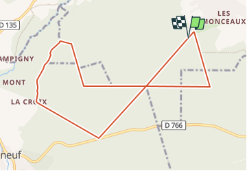
Trail Walking of 9.8 km to be discovered at Centre-Loire Valley, Loir-et-Cher, Saint-Sulpice-de-Pommeray. This trail is proposed by marionneau.
Description
Marche rapide - trajet envoyé par Jacky - sens inverse de la BBR 2025-01-11 - parcours recommandé si pluie ou terrains trop chargés d'eau
Positioning
Country:
France
Region :
Centre-Loire Valley
Department/Province :
Loir-et-Cher
Municipality :
Saint-Sulpice-de-Pommeray
Location:
Unknown
Start:(Dec)
Start:(UTM)
369325 ; 5273011 (31T) N.
Comments
Trails nearby
![Trail Walking Valencisse - Circuit n°4 de Moulineuf - Photo](https://media.geolcdn.com/t/375/260/ext.jpg?maxdim=2&url=https%3A%2F%2Fservices.sitytrail.com%2FGeolivesWS%2FDownloadMedia.ashx%3FTrailID%3D317925%26Media%3D17343_6.jpg)
![Walking Walking](https://static1.geolcdn.com/sitytour/trail-icons/101.png)
Circuit n°4 de Moulineuf
Walking
Medium
(1)
Valencisse,
Centre-Loire Valley,
Loir-et-Cher,
France
![](/images/other/stat-length.png)
15 km | 18.4 km-effort
3h 45min
![](https://static1.geolcdn.com/siteimages/upload/files/16400158638029165_repeat_loop_refresh_sync_direction_icon.png)
Yes
![Trail Walking Valencisse - BBR 2025-02-01 Valentine de Milan 10km - Photo](https://media.geolcdn.com/t/375/260/ext.jpg?maxdim=2&url=https%3A%2F%2Fstatic1.geolcdn.com%2Fsiteimages%2Fupload%2Ffiles%2F1553511878bg_sport_marche.png)
![Walking Walking](https://static1.geolcdn.com/sitytour/trail-icons/101.png)
BBR 2025-02-01 Valentine de Milan 10km
Walking
Medium
(1)
Valencisse,
Centre-Loire Valley,
Loir-et-Cher,
France
![](/images/other/stat-length.png)
10.7 km | 12 km-effort
1h 35min
![](https://static1.geolcdn.com/siteimages/upload/files/16400158638029165_repeat_loop_refresh_sync_direction_icon.png)
Yes
![Trail On foot Valencisse - Chambon-Molineuf par Champigny - Photo](https://media.geolcdn.com/t/375/260/ext.jpg?maxdim=2&url=https%3A%2F%2Fstatic1.geolcdn.com%2Fsiteimages%2Fupload%2Ffiles%2F1545311037marcheuse_200dpi.jpg)
![On foot On foot](https://static1.geolcdn.com/sitytour/trail-icons/100.png)
Chambon-Molineuf par Champigny
On foot
Easy
(1)
Valencisse,
Centre-Loire Valley,
Loir-et-Cher,
France
![](/images/other/stat-length.png)
14.7 km | 18.1 km-effort
Unknown
![](https://static1.geolcdn.com/siteimages/upload/files/16400158638029165_repeat_loop_refresh_sync_direction_icon.png)
Yes
![Trail Walking Valencisse - les rinceaux - Photo](https://media.geolcdn.com/t/375/260/5ccb405d-d4f6-4381-9494-3cfd59f9f42e.jpg&format=jpg&maxdim=2)
![Walking Walking](https://static1.geolcdn.com/sitytour/trail-icons/101.png)
les rinceaux
Walking
Medium
Valencisse,
Centre-Loire Valley,
Loir-et-Cher,
France
![](/images/other/stat-length.png)
9.1 km | 10.8 km-effort
3h 13min
![](https://static1.geolcdn.com/siteimages/upload/files/16400158638029165_repeat_loop_refresh_sync_direction_icon.png)
Yes
![Trail Walking Fossé - Fossé - Vallée de la Cisse - Photo](https://media.geolcdn.com/t/375/260/7e619ff4-42ff-420d-8977-5c45d5eb4d52.jpg&format=jpg&maxdim=2)
![Walking Walking](https://static1.geolcdn.com/sitytour/trail-icons/101.png)
Fossé - Vallée de la Cisse
Walking
Medium
Fossé,
Centre-Loire Valley,
Loir-et-Cher,
France
![](/images/other/stat-length.png)
9.1 km | 10.3 km-effort
2h 20min
![](https://static1.geolcdn.com/siteimages/upload/files/16400158638029165_repeat_loop_refresh_sync_direction_icon.png)
Yes
![Trail Walking Saint-Sulpice-de-Pommeray - Saint-Sulpice-de-Pommeray - Photo](https://media.geolcdn.com/t/375/260/9d1ec0a7-eadc-4416-a6d9-fa4cc5a06fea.jpg&format=jpg&maxdim=2)
![Walking Walking](https://static1.geolcdn.com/sitytour/trail-icons/101.png)
Saint-Sulpice-de-Pommeray
Walking
Medium
Saint-Sulpice-de-Pommeray,
Centre-Loire Valley,
Loir-et-Cher,
France
![](/images/other/stat-length.png)
24 km | 29 km-effort
8h 41min
![](https://static1.geolcdn.com/siteimages/upload/files/16400158638029165_repeat_loop_refresh_sync_direction_icon.png)
Yes
![Trail Walking Valencisse - Circuit n°3 de Molineuf - Photo](https://media.geolcdn.com/t/375/260/ext.jpg?maxdim=2&url=https%3A%2F%2Fservices.sitytrail.com%2FGeolivesWS%2FDownloadMedia.ashx%3FTrailID%3D317924%26Media%3D17342_5.jpg)
![Walking Walking](https://static1.geolcdn.com/sitytour/trail-icons/101.png)
Circuit n°3 de Molineuf
Walking
Medium
Valencisse,
Centre-Loire Valley,
Loir-et-Cher,
France
![](/images/other/stat-length.png)
12.3 km | 14.6 km-effort
3h 0min
![](https://static1.geolcdn.com/siteimages/upload/files/16400158638029165_repeat_loop_refresh_sync_direction_icon.png)
Yes
![Trail Walking Valencisse - Circuit n°2 de Molineuf - Photo](https://media.geolcdn.com/t/375/260/ext.jpg?maxdim=2&url=https%3A%2F%2Fservices.sitytrail.com%2FGeolivesWS%2FDownloadMedia.ashx%3FTrailID%3D317923%26Media%3D17341_6.jpg)
![Walking Walking](https://static1.geolcdn.com/sitytour/trail-icons/101.png)
Circuit n°2 de Molineuf
Walking
Medium
Valencisse,
Centre-Loire Valley,
Loir-et-Cher,
France
![](/images/other/stat-length.png)
9 km | 11.6 km-effort
2h 45min
![](https://static1.geolcdn.com/siteimages/upload/files/16400158638029165_repeat_loop_refresh_sync_direction_icon.png)
Yes
![Trail Walking Valencisse - Circuit n°1 de Molineuf - Photo](https://media.geolcdn.com/t/375/260/ext.jpg?maxdim=2&url=https%3A%2F%2Fservices.sitytrail.com%2FGeolivesWS%2FDownloadMedia.ashx%3FTrailID%3D317922%26Media%3D17340_6.jpg)
![Walking Walking](https://static1.geolcdn.com/sitytour/trail-icons/101.png)
Circuit n°1 de Molineuf
Walking
Difficult
Valencisse,
Centre-Loire Valley,
Loir-et-Cher,
France
![](/images/other/stat-length.png)
16.9 km | 20 km-effort
4h 15min
![](https://static1.geolcdn.com/siteimages/upload/files/16400158638029165_repeat_loop_refresh_sync_direction_icon.png)
Yes