![](/images/other/stat-length.png)
![Trail On foot Albrechtice nad Vltavou - Historická stezka Albrechtickem - Photo](https://media.geolcdn.com/t/1900/400/4ec0b7ff-0c97-4fba-b42c-637cce5f02aa.jpeg&format=pjpeg&maxdim=2)
Historická stezka Albrechtickem
SityTrail - itinéraires balisés pédestres
Tous les sentiers balisés d’Europe GUIDE+
![Length](/images/other/stat-length.png)
Length
13.5 km
![Max alt](https://static1.geolcdn.com/siteimages/upload/files/1508320355ic_sort_altitude_max_24dp.png)
Max alt
447 m
![Uphill gradient](https://static1.geolcdn.com/siteimages/upload/files/1508320355ic_sort_den_pos_24dp.png)
Uphill gradient
211 m
![Km-Effort](/images/other/stat-length.png)
Km-Effort
16.3 km
![Min alt](https://static1.geolcdn.com/siteimages/upload/files/1508320355ic_sort_altitude_min_24dp.png)
Min alt
382 m
![Downhill gradient](https://static1.geolcdn.com/siteimages/upload/files/1508320355ic_sort_den_neg_24dp.png)
Downhill gradient
210 m
![Boucle](https://static1.geolcdn.com/siteimages/upload/files/16400158638029165_repeat_loop_refresh_sync_direction_icon.png)
Boucle
No
Signpost
Creation date :
2025-02-07 21:06:20.979
Updated on :
2025-02-07 21:06:20.979
![On foot](https://static1.geolcdn.com/sitytour/trail-icons/100.png)
3h42
Difficulty : Easy
![Scan this QR Code to open this trail in the SityTrail application](https://capi.geolives.com/qq0zvz2zws4bq2lad0pu/sitytour/trails/4346760/qr.png?size=200)
FREE GPS app for hiking
About
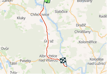
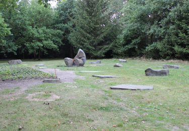
Trail On foot of 13.5 km to be discovered at Southwest, Jihočeský kraj, Albrechtice nad Vltavou. This trail is proposed by SityTrail - itinéraires balisés pédestres.
Description
Trail created by obec Albrechtice n. Vlt..
chybi zastaveni 8 v Albrechticich
Positioning
Country:
Czech Republic
Region :
Southwest
Department/Province :
Jihočeský kraj
Municipality :
Albrechtice nad Vltavou
Location:
Unknown
Start:(Dec)
Start:(UTM)
448862 ; 5464744 (33U) N.
Comments
Trails nearby
![Trail On foot Písek - [Č] Písek - Velká Brašna - Photo](https://media.geolcdn.com/t/375/260/bfca88cd-0504-44c2-9a66-8e406f087387.jpeg&format=jpg&maxdim=2)
![On foot On foot](https://static1.geolcdn.com/sitytour/trail-icons/100.png)
[Č] Písek - Velká Brašna
On foot
Easy
Písek,
Southwest,
Jihočeský kraj,
Czech Republic
![](/images/other/stat-length.png)
6.3 km | 8.9 km-effort
2h 1min
![](https://static1.geolcdn.com/siteimages/upload/files/16400158638029165_repeat_loop_refresh_sync_direction_icon.png)
No
![Trail On foot Týn nad Vltavou - [Ž] Nad Překvapením - Semenec (rozhl.) - Photo](https://media.geolcdn.com/t/375/260/5b43c739-7905-4a0c-8a8b-63468991b1a9.jpeg&format=jpg&maxdim=2)
![On foot On foot](https://static1.geolcdn.com/sitytour/trail-icons/100.png)
[Ž] Nad Překvapením - Semenec (rozhl.)
On foot
Easy
Týn nad Vltavou,
Southwest,
Jihočeský kraj,
Czech Republic
![](/images/other/stat-length.png)
3.1 km | 4.1 km-effort
55min
![](https://static1.geolcdn.com/siteimages/upload/files/16400158638029165_repeat_loop_refresh_sync_direction_icon.png)
No
![Trail On foot Všemyslice - naučná stezka Za Neznašovským kohoutem - Photo](https://media.geolcdn.com/t/375/260/d0ca1351-ea77-4047-a33d-45b3a503a3ef.jpeg&format=jpg&maxdim=2)
![On foot On foot](https://static1.geolcdn.com/sitytour/trail-icons/100.png)
naučná stezka Za Neznašovským kohoutem
On foot
Easy
Všemyslice,
Southwest,
Jihočeský kraj,
Czech Republic
![](/images/other/stat-length.png)
4.7 km | 6.4 km-effort
1h 27min
![](https://static1.geolcdn.com/siteimages/upload/files/16400158638029165_repeat_loop_refresh_sync_direction_icon.png)
Yes
![Trail On foot Milevsko - [Č] Milevsko - Jetětice - Photo](https://media.geolcdn.com/t/375/260/19b73443-10f3-4ee2-b906-2593e9794aea.jpeg&format=jpg&maxdim=2)
![On foot On foot](https://static1.geolcdn.com/sitytour/trail-icons/100.png)
[Č] Milevsko - Jetětice
On foot
Easy
Milevsko,
Southwest,
Jihočeský kraj,
Czech Republic
![](/images/other/stat-length.png)
11.8 km | 14.8 km-effort
3h 21min
![](https://static1.geolcdn.com/siteimages/upload/files/16400158638029165_repeat_loop_refresh_sync_direction_icon.png)
No
![Trail On foot Písek - NS Od Ptáčkovny k Živci - Photo](https://media.geolcdn.com/t/375/260/cb7dd3a0-b882-4d93-a910-805045955afa.jpeg&format=jpg&maxdim=2)
![On foot On foot](https://static1.geolcdn.com/sitytour/trail-icons/100.png)
NS Od Ptáčkovny k Živci
On foot
Easy
Písek,
Southwest,
Jihočeský kraj,
Czech Republic
![](/images/other/stat-length.png)
3.4 km | 5.5 km-effort
1h 15min
![](https://static1.geolcdn.com/siteimages/upload/files/16400158638029165_repeat_loop_refresh_sync_direction_icon.png)
No
![Trail On foot Milevsko - [Ž] Budák rybník - Karlov - Photo](https://media.geolcdn.com/t/375/260/6a7dbc34-5b93-44a1-bcc9-52d789012a05.jpeg&format=jpg&maxdim=2)
![On foot On foot](https://static1.geolcdn.com/sitytour/trail-icons/100.png)
[Ž] Budák rybník - Karlov
On foot
Easy
Milevsko,
Southwest,
Jihočeský kraj,
Czech Republic
![](/images/other/stat-length.png)
3.6 km | 4.3 km-effort
58min
![](https://static1.geolcdn.com/siteimages/upload/files/16400158638029165_repeat_loop_refresh_sync_direction_icon.png)
No
![Trail On foot Lety - NS Lety - Photo](https://media.geolcdn.com/t/375/260/d835afd1-38cc-4ff7-be4f-069fcf082a0b.jpeg&format=jpg&maxdim=2)
![On foot On foot](https://static1.geolcdn.com/sitytour/trail-icons/100.png)
![Trail On foot Písek - NS Školní polesí - Hůrka - Photo](https://media.geolcdn.com/t/375/260/7133faff-b21d-41b6-9f51-c54858ab31a0.jpeg&format=jpg&maxdim=2)
![On foot On foot](https://static1.geolcdn.com/sitytour/trail-icons/100.png)
NS Školní polesí - Hůrka
On foot
Easy
Písek,
Southwest,
Jihočeský kraj,
Czech Republic
![](/images/other/stat-length.png)
9.5 km | 12 km-effort
2h 43min
![](https://static1.geolcdn.com/siteimages/upload/files/16400158638029165_repeat_loop_refresh_sync_direction_icon.png)
Yes
![Trail On foot Nadějkov - Naučná stezka Nadějkovsko - Photo](https://media.geolcdn.com/t/375/260/b70d83df-174f-4a46-bba5-47ca798e43f1.jpeg&format=jpg&maxdim=2)
![On foot On foot](https://static1.geolcdn.com/sitytour/trail-icons/100.png)
Naučná stezka Nadějkovsko
On foot
Easy
Nadějkov,
Southwest,
Jihočeský kraj,
Czech Republic
![](/images/other/stat-length.png)
11.9 km | 16.1 km-effort
3h 40min
![](https://static1.geolcdn.com/siteimages/upload/files/16400158638029165_repeat_loop_refresh_sync_direction_icon.png)
Yes