Trail On foot Banks Peninsula Community - Te Ara Pātaka - Photo

Tous les sentiers balisés d’Europe GUIDE+

© OpenStreetMap contributors
Length
Length
29 km
Max alt
Max alt
919 m
Uphill gradient
Uphill gradient
1186 m
Km-Effort
Km-Effort  
46 km
Min alt
Min alt
143 m
Downhill gradient
Downhill gradient
1498 m
Boucle
Boucle
No
Signpost
Signpost
Creation date :
2025-02-07 20:46:39.252
Updated on :
2025-02-07 20:46:39.252

(0 Reviews)

On foot
On foot
10h29
Difficulty : Very difficult

Scan this QR Code to open this trail in the SityTrail application

FREE GPS app for hiking

Logo SityTrail SityTrail

IGN / Geographical institutes

Download SityTrail from the App Store Download SityTrail from Google Play

Logo SityTrail SityTrail World

The world is yours!

Download SityTrail from the App Store Download SityTrail from Google Play Download SityTrail on Huawei AppGallery

About

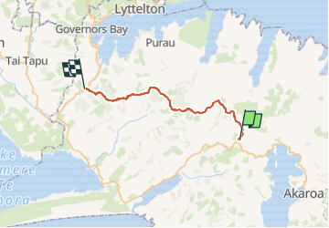
Trail On foot of 29 km to be discovered at Canterbury, Christchurch City, Banks Peninsula Community. This trail is proposed by SityTrail - itinéraires balisés pédestres.

Description

Enjoy magnificent views over Banks Peninsula, the Canterbury plains, Southern Alps and Pacific Ocean on this track, which is about an hour's drive from Christchurch.

Website: https://www.doc.govt.nz/parks-and-recreation/places-to-go/canterbury/places/banks-peninsula-area/things-to-do/te-ara-pataka/te-ara-pataka-summit-walkway/

Elevation profile

Photos

Positioning

Country:
New Zealand
Region :
Canterbury
Department/Province :
Christchurch City
Municipality :
Banks Peninsula Community
Location:
Unknown
Start:(UTM)
650625 ; 5154551 (59G) S.

Trails nearby

Trail On foot Spreydon-Cashmere Community - Hiking trail - Photo
On foot
GUIDE+

On foot

Easy
Spreydon-Cashmere Community, Canterbury, Christchurch City, New Zealand
4.4 km | 8.3 km-effort
1h 53min
No
Trail On foot Banks Peninsula Community - Mount Herbert Walkway - Photo
On foot
GUIDE+

On foot

Medium
Banks Peninsula Community, Canterbury, Christchurch City, New Zealand
15.9 km | 28 km-effort
6h 23min
No
Trail Walking Banks Peninsula Community - CassBay CraterRim BridalPath Lyttelton 250114 - Photo
Walking
JohnTompa

Walking

Difficult
Banks Peninsula Community, Canterbury, Christchurch City, New Zealand
5.5 km | 10.6 km-effort
4h 45min
No
Trail Walking Banks Peninsula Community - GreenberryTree 250115 - Photo
Walking
JohnTompa

Walking

Easy
Banks Peninsula Community, Canterbury, Christchurch City, New Zealand
337 m | 457 m-effort
6min
Yes
Trail Walking Banks Peninsula Community - Governors Bay Jetty 241228 - Photo
Walking
JohnTompa

Walking

Easy
Banks Peninsula Community, Canterbury, Christchurch City, New Zealand
2.2 km | 2.9 km-effort
53min
Yes


Close
My subscriptions