![](/images/other/stat-length.png)
![Trail On foot Obecnice - Lesnická naučná stezka Klobouček - Photo](https://media.geolcdn.com/t/1900/400/d6dd3647-c2e5-4711-b472-86975ef68c78.jpeg&format=pjpeg&maxdim=2)
Lesnická naučná stezka Klobouček
SityTrail - itinéraires balisés pédestres
Tous les sentiers balisés d’Europe GUIDE+
![Length](/images/other/stat-length.png)
Length
7.2 km
![Max alt](https://static1.geolcdn.com/siteimages/upload/files/1508320355ic_sort_altitude_max_24dp.png)
Max alt
715 m
![Uphill gradient](https://static1.geolcdn.com/siteimages/upload/files/1508320355ic_sort_den_pos_24dp.png)
Uphill gradient
208 m
![Km-Effort](/images/other/stat-length.png)
Km-Effort
9.9 km
![Min alt](https://static1.geolcdn.com/siteimages/upload/files/1508320355ic_sort_altitude_min_24dp.png)
Min alt
518 m
![Downhill gradient](https://static1.geolcdn.com/siteimages/upload/files/1508320355ic_sort_den_neg_24dp.png)
Downhill gradient
206 m
![Boucle](https://static1.geolcdn.com/siteimages/upload/files/16400158638029165_repeat_loop_refresh_sync_direction_icon.png)
Boucle
Yes
Signpost
Creation date :
2025-02-07 20:38:32.124
Updated on :
2025-02-07 20:38:32.124
![On foot](https://static1.geolcdn.com/sitytour/trail-icons/100.png)
2h15
Difficulty : Easy
![Scan this QR Code to open this trail in the SityTrail application](https://capi.geolives.com/qq0zvz2zws4bq2lad0pu/sitytour/trails/4346716/qr.png?size=200)
FREE GPS app for hiking
About
Trail On foot of 7.2 km to be discovered at Central Bohemia, Unknown, Obecnice. This trail is proposed by SityTrail - itinéraires balisés pédestres.
Description
Realizaci naučné stezky mají na starosti Vojenské lesy a statky ČR, s.p., grafický design Tereza Pejřimovská & Lucie Marková, texty Václav Pernegr…
Website: https://www.obecnice.cz/lesnicka-naucna-stezka-kloboucek/
Positioning
Country:
Czech Republic
Region :
Central Bohemia
Department/Province :
Unknown
Municipality :
Obecnice
Location:
Unknown
Start:(Dec)
Start:(UTM)
424039 ; 5507375 (33U) N.
Comments
Trails nearby
![Trail On foot Obecnice - [M] Orlov - Třemošná , místní okruh - Photo](https://media.geolcdn.com/t/375/260/eba4fd36-4577-4ad0-82a2-9f28ca4bc9f7.jpeg&format=jpg&maxdim=2)
![On foot On foot](https://static1.geolcdn.com/sitytour/trail-icons/100.png)
[M] Orlov - Třemošná , místní okruh
On foot
Easy
Obecnice,
Central Bohemia,
Unknown,
Czech Republic
![](/images/other/stat-length.png)
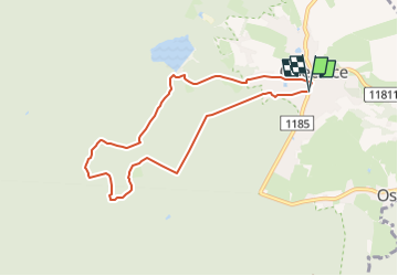
3.2 km | 5.1 km-effort
1h 9min
![](https://static1.geolcdn.com/siteimages/upload/files/16400158638029165_repeat_loop_refresh_sync_direction_icon.png)
Yes
![Trail On foot Obecnice - [Z] Pila - Bohutín - Photo](https://media.geolcdn.com/t/375/260/ed2c13c9-f98d-44a7-859e-fcc2745957f4.jpeg&format=jpg&maxdim=2)
![On foot On foot](https://static1.geolcdn.com/sitytour/trail-icons/100.png)
[Z] Pila - Bohutín
On foot
Easy
Obecnice,
Central Bohemia,
Unknown,
Czech Republic
![](/images/other/stat-length.png)
4.1 km | 5 km-effort
1h 8min
![](https://static1.geolcdn.com/siteimages/upload/files/16400158638029165_repeat_loop_refresh_sync_direction_icon.png)
No