![](/images/other/stat-length.png)
![Trail On foot Devonport-Takapuna - Te Araroa - 02 Auckland - j Devonport to Onehunga - Photo](https://media.geolcdn.com/t/1900/400/7efc287a-737b-4550-a667-307af9b6ec7a.jpeg&format=pjpeg&maxdim=2)
Te Araroa - 02 Auckland - j Devonport to Onehunga
SityTrail - itinéraires balisés pédestres
Tous les sentiers balisés d’Europe GUIDE+
![Length](/images/other/stat-length.png)
Length
19.1 km
![Max alt](https://static1.geolcdn.com/siteimages/upload/files/1508320355ic_sort_altitude_max_24dp.png)
Max alt
195 m
![Uphill gradient](https://static1.geolcdn.com/siteimages/upload/files/1508320355ic_sort_den_pos_24dp.png)
Uphill gradient
360 m
![Km-Effort](/images/other/stat-length.png)
Km-Effort
24 km
![Min alt](https://static1.geolcdn.com/siteimages/upload/files/1508320355ic_sort_altitude_min_24dp.png)
Min alt
0 m
![Downhill gradient](https://static1.geolcdn.com/siteimages/upload/files/1508320355ic_sort_den_neg_24dp.png)
Downhill gradient
353 m
![Boucle](https://static1.geolcdn.com/siteimages/upload/files/16400158638029165_repeat_loop_refresh_sync_direction_icon.png)
Boucle
No
Signpost
Creation date :
2025-02-07 19:48:30.253
Updated on :
2025-02-07 19:48:30.253
![On foot](https://static1.geolcdn.com/sitytour/trail-icons/100.png)
5h25
Difficulty : Medium
![Scan this QR Code to open this trail in the SityTrail application](https://capi.geolives.com/qq0zvz2zws4bq2lad0pu/sitytour/trails/4346629/qr.png?size=200)
FREE GPS app for hiking
About
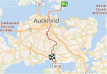
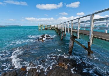
Trail On foot of 19.1 km to be discovered at Auckland, Unknown, Devonport-Takapuna. This trail is proposed by SityTrail - itinéraires balisés pédestres.
Description
"official" distance does not include ferry crossing of about 4 km from Devonport to CBD
Positioning
Country:
New Zealand
Region :
Auckland
Department/Province :
Unknown
Municipality :
Devonport-Takapuna
Location:
Unknown
Start:(Dec)
Start:(UTM)
303422 ; 5921359 (60H) S.
Comments
Trails nearby
![Trail On foot Māngere-Ōtāhuhu - Watercare Coastal Walkway - Photo](https://media.geolcdn.com/t/375/260/493c3a1f-fb22-4a2d-9e7e-65933b14f376.jpeg&format=jpg&maxdim=2)
![On foot On foot](https://static1.geolcdn.com/sitytour/trail-icons/100.png)
Watercare Coastal Walkway
On foot
Easy
Māngere-Ōtāhuhu,
Auckland,
Unknown,
New Zealand
![](/images/other/stat-length.png)
6.2 km | 6.6 km-effort
1h 29min
![](https://static1.geolcdn.com/siteimages/upload/files/16400158638029165_repeat_loop_refresh_sync_direction_icon.png)
No
![Trail On foot Ōtara-Papatoetoe - Te Araroa - 02 Auckland - m Puhinui to Totara Park, Wairere Road, Manurewa - Photo](https://media.geolcdn.com/t/375/260/6a40591b-0473-4b40-9cb2-a2fc3971e9cf.jpeg&format=jpg&maxdim=2)
![On foot On foot](https://static1.geolcdn.com/sitytour/trail-icons/100.png)
Te Araroa - 02 Auckland - m Puhinui to Totara Park, Wairere Road, Manurewa
On foot
Easy
Ōtara-Papatoetoe,
Auckland,
Unknown,
New Zealand
![](/images/other/stat-length.png)
9.8 km | 11.1 km-effort
2h 30min
![](https://static1.geolcdn.com/siteimages/upload/files/16400158638029165_repeat_loop_refresh_sync_direction_icon.png)
No
![Trail On foot Maungakiekie-Tāmaki - Te Araroa - 02 Auckland - k Onehunga to Puhinui - Photo](https://media.geolcdn.com/t/375/260/ext.jpg?maxdim=2&url=https%3A%2F%2Fstatic1.geolcdn.com%2Fsiteimages%2Fupload%2Ffiles%2F1545311037marcheuse_200dpi.jpg)
![On foot On foot](https://static1.geolcdn.com/sitytour/trail-icons/100.png)
Te Araroa - 02 Auckland - k Onehunga to Puhinui
On foot
Medium
Maungakiekie-Tāmaki,
Auckland,
Unknown,
New Zealand
![](/images/other/stat-length.png)
23 km | 25 km-effort
5h 47min
![](https://static1.geolcdn.com/siteimages/upload/files/16400158638029165_repeat_loop_refresh_sync_direction_icon.png)
No
![Trail On foot Hibiscus and Bays - Te Araroa - 02 Auckland - h Long Bay to Devonport - Photo](https://media.geolcdn.com/t/375/260/3c9cf35c-c383-4e73-838b-ce3ea092a4f6.jpeg&format=jpg&maxdim=2)
![On foot On foot](https://static1.geolcdn.com/sitytour/trail-icons/100.png)
Te Araroa - 02 Auckland - h Long Bay to Devonport
On foot
Medium
Hibiscus and Bays,
Auckland,
Unknown,
New Zealand
![](/images/other/stat-length.png)
24 km | 30 km-effort
6h 48min
![](https://static1.geolcdn.com/siteimages/upload/files/16400158638029165_repeat_loop_refresh_sync_direction_icon.png)
No
![Trail On foot Hibiscus and Bays - Te Araroa NI Low tide - Photo](https://media.geolcdn.com/t/375/260/5f39ba41-eb25-4597-a7bd-556f8a65d6d4.jpeg&format=jpg&maxdim=2)
![On foot On foot](https://static1.geolcdn.com/sitytour/trail-icons/100.png)
Te Araroa NI Low tide
On foot
Easy
Hibiscus and Bays,
Auckland,
Unknown,
New Zealand
![](/images/other/stat-length.png)
6 km | 7.6 km-effort
1h 43min
![](https://static1.geolcdn.com/siteimages/upload/files/16400158638029165_repeat_loop_refresh_sync_direction_icon.png)
No
![Trail On foot Waiheke - Rangitoto Coastal Walk - Photo](https://media.geolcdn.com/t/375/260/b2dbe584-2da4-488a-9af0-03542fe64cac.jpeg&format=jpg&maxdim=2)
![On foot On foot](https://static1.geolcdn.com/sitytour/trail-icons/100.png)
Rangitoto Coastal Walk
On foot
Easy
Waiheke,
Auckland,
Unknown,
New Zealand
![](/images/other/stat-length.png)
6.1 km | 7 km-effort
1h 35min
![](https://static1.geolcdn.com/siteimages/upload/files/16400158638029165_repeat_loop_refresh_sync_direction_icon.png)
No