![](/images/other/stat-length.png)
![Trail On foot Mikulovice - NS moravského včelařství - Photo](https://media.geolcdn.com/t/1900/400/aecb43d3-b381-46bc-996f-8597bd3a76e0.jpeg&format=pjpeg&maxdim=2)
NS moravského včelařství
SityTrail - itinéraires balisés pédestres
Tous les sentiers balisés d’Europe GUIDE+
![Length](/images/other/stat-length.png)
Length
4.1 km
![Max alt](https://static1.geolcdn.com/siteimages/upload/files/1508320355ic_sort_altitude_max_24dp.png)
Max alt
358 m
![Uphill gradient](https://static1.geolcdn.com/siteimages/upload/files/1508320355ic_sort_den_pos_24dp.png)
Uphill gradient
59 m
![Km-Effort](/images/other/stat-length.png)
Km-Effort
4.9 km
![Min alt](https://static1.geolcdn.com/siteimages/upload/files/1508320355ic_sort_altitude_min_24dp.png)
Min alt
305 m
![Downhill gradient](https://static1.geolcdn.com/siteimages/upload/files/1508320355ic_sort_den_neg_24dp.png)
Downhill gradient
58 m
![Boucle](https://static1.geolcdn.com/siteimages/upload/files/16400158638029165_repeat_loop_refresh_sync_direction_icon.png)
Boucle
Yes
Signpost
Creation date :
2025-02-07 19:08:51.13
Updated on :
2025-02-07 19:08:51.13
![On foot](https://static1.geolcdn.com/sitytour/trail-icons/100.png)
1h06
Difficulty : Easy
![Scan this QR Code to open this trail in the SityTrail application](https://capi.geolives.com/qq0zvz2zws4bq2lad0pu/sitytour/trails/4346581/qr.png?size=200)
FREE GPS app for hiking
About
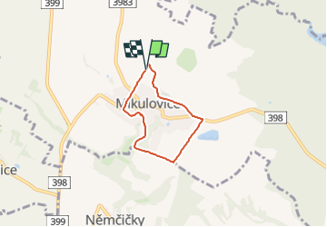
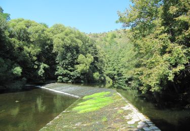
Trail On foot of 4.1 km to be discovered at Southeast, Jihomoravský kraj, Mikulovice. This trail is proposed by SityTrail - itinéraires balisés pédestres.
Description
Trail created by Mikulovice.
Positioning
Country:
Czech Republic
Region :
Southeast
Department/Province :
Jihomoravský kraj
Municipality :
Mikulovice
Location:
Unknown
Start:(Dec)
Start:(UTM)
580107 ; 5423693 (33U) N.
Comments
Trails nearby
![Trail On foot Miroslav - Okruh Miroslavské kopce - Photo](https://media.geolcdn.com/t/375/260/3221cc3c-a9f3-4f28-880f-beaad17e940f.jpeg&format=jpg&maxdim=2)
![On foot On foot](https://static1.geolcdn.com/sitytour/trail-icons/100.png)
Okruh Miroslavské kopce
On foot
Easy
Miroslav,
Southeast,
Jihomoravský kraj,
Czech Republic
![](/images/other/stat-length.png)
4.4 km | 5.7 km-effort
1h 17min
![](https://static1.geolcdn.com/siteimages/upload/files/16400158638029165_repeat_loop_refresh_sync_direction_icon.png)
Yes
![Trail On foot Onšov - NS Karla Claryho - Photo](https://media.geolcdn.com/t/375/260/3ebb76a8-92c2-4bef-81de-0753f94a5be8.jpeg&format=jpg&maxdim=2)
![On foot On foot](https://static1.geolcdn.com/sitytour/trail-icons/100.png)
NS Karla Claryho
On foot
Easy
Onšov,
Southeast,
Jihomoravský kraj,
Czech Republic
![](/images/other/stat-length.png)
3.5 km | 5.1 km-effort
1h 9min
![](https://static1.geolcdn.com/siteimages/upload/files/16400158638029165_repeat_loop_refresh_sync_direction_icon.png)
No
![Trail On foot Šatov - NS Za historií, vínem a opevněním - Photo](https://media.geolcdn.com/t/375/260/55b44c17-a805-4f4d-b8d8-eedf73749f9a.jpeg&format=jpg&maxdim=2)
![On foot On foot](https://static1.geolcdn.com/sitytour/trail-icons/100.png)
NS Za historií, vínem a opevněním
On foot
Easy
Šatov,
Southeast,
Jihomoravský kraj,
Czech Republic
![](/images/other/stat-length.png)
3.1 km | 3.6 km-effort
48min
![](https://static1.geolcdn.com/siteimages/upload/files/16400158638029165_repeat_loop_refresh_sync_direction_icon.png)
Yes
![Trail On foot Božice - NS Údolím lásky - Photo](https://media.geolcdn.com/t/375/260/33569034-0db8-4d72-a0e8-ffb991a038f9.jpeg&format=jpg&maxdim=2)
![On foot On foot](https://static1.geolcdn.com/sitytour/trail-icons/100.png)
NS Údolím lásky
On foot
Easy
Božice,
Southeast,
Jihomoravský kraj,
Czech Republic
![](/images/other/stat-length.png)
3.8 km | 4.2 km-effort
56min
![](https://static1.geolcdn.com/siteimages/upload/files/16400158638029165_repeat_loop_refresh_sync_direction_icon.png)
No
![Trail On foot Lesonice - Lesonická školní naučná stezka - Photo](https://media.geolcdn.com/t/375/260/b285cb7a-55e5-4a04-996b-db6be9f92a12.jpeg&format=jpg&maxdim=2)
![On foot On foot](https://static1.geolcdn.com/sitytour/trail-icons/100.png)
Lesonická školní naučná stezka
On foot
Easy
Lesonice,
Southeast,
Jihomoravský kraj,
Czech Republic
![](/images/other/stat-length.png)
3.7 km | 4.8 km-effort
1h 5min
![](https://static1.geolcdn.com/siteimages/upload/files/16400158638029165_repeat_loop_refresh_sync_direction_icon.png)
Yes
![Trail On foot Mohelno - Naučná stezka národní přírodní rezervace Mohelenská hadcová step - Photo](https://media.geolcdn.com/t/375/260/83a4f499-7909-4101-ba16-31f711dd9df3.jpeg&format=jpg&maxdim=2)
![On foot On foot](https://static1.geolcdn.com/sitytour/trail-icons/100.png)
Naučná stezka národní přírodní rezervace Mohelenská hadcová step
On foot
Easy
Mohelno,
Southeast,
Kraj Vysočina,
Czech Republic
![](/images/other/stat-length.png)
3.2 km | 4.8 km-effort
1h 5min
![](https://static1.geolcdn.com/siteimages/upload/files/16400158638029165_repeat_loop_refresh_sync_direction_icon.png)
Yes
![Trail On foot Lesná - [Ž] Lesná - Ledové sluje - vyhlídka - Photo](https://media.geolcdn.com/t/375/260/ac13b2a6-a2a6-49b6-b151-4f6483ad5d2b.jpeg&format=jpg&maxdim=2)
![On foot On foot](https://static1.geolcdn.com/sitytour/trail-icons/100.png)
[Ž] Lesná - Ledové sluje - vyhlídka
On foot
Easy
Lesná,
Southeast,
Jihomoravský kraj,
Czech Republic
![](/images/other/stat-length.png)
3.3 km | 4.2 km-effort
56min
![](https://static1.geolcdn.com/siteimages/upload/files/16400158638029165_repeat_loop_refresh_sync_direction_icon.png)
No
![Trail On foot Šumná - [M] Šumná - Hardegg - Photo](https://media.geolcdn.com/t/375/260/57463325-aa2b-454f-9571-0eca5929e103.jpeg&format=jpg&maxdim=2)
![On foot On foot](https://static1.geolcdn.com/sitytour/trail-icons/100.png)
[M] Šumná - Hardegg
On foot
Easy
Šumná,
Southeast,
Jihomoravský kraj,
Czech Republic
![](/images/other/stat-length.png)
11.2 km | 13.5 km-effort
3h 3min
![](https://static1.geolcdn.com/siteimages/upload/files/16400158638029165_repeat_loop_refresh_sync_direction_icon.png)
No
![Trail On foot Znojmo - [Č] Vranov - Železné schody - Photo](https://media.geolcdn.com/t/375/260/ca9151e2-7333-4e44-883d-767759caa06c.jpeg&format=jpg&maxdim=2)
![On foot On foot](https://static1.geolcdn.com/sitytour/trail-icons/100.png)
[Č] Vranov - Železné schody
On foot
Difficult
Znojmo,
Southeast,
Jihomoravský kraj,
Czech Republic
![](/images/other/stat-length.png)
30 km | 40 km-effort
9h 10min
![](https://static1.geolcdn.com/siteimages/upload/files/16400158638029165_repeat_loop_refresh_sync_direction_icon.png)
No