


保良新城コース

SityTrail - itinéraires balisés pédestres
Tous les sentiers balisés d’Europe GUIDE+
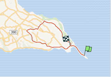

Length
15.2 km

Max alt
72 m

Uphill gradient
169 m
Km-Effort
17.5 km

Min alt
10 m

Downhill gradient
159 m
Boucle
No

Signpost
Creation date :
2025-02-07 18:59:26.006
Updated on :
2025-02-07 18:59:26.006
3h58
Difficulty : Easy

FREE GPS app for hiking
 SityTrail
IGN / Geographical institutes
SityTrail World
The world is yours!
About
Trail On foot of 15.2 km to be discovered at Okinawa Prefecture. This trail is proposed by SityTrail - itinéraires balisés pédestres.
Photos


Positioning
Country:
Japan
Region :
Okinawa Prefecture
Department/Province :
Unknown
Municipality :
Unknown
Location:
Unknown
Start:(Dec)
Start:(UTM)
749353 ; 2736422 (51R) N.
Comments
Trails nearby