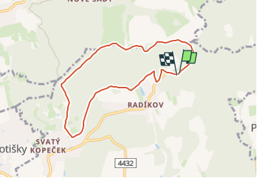
3.2 km | 4.1 km-effort
zelený místní okruh Svatý kopeček
SityTrail - itinéraires balisés pédestres
Tous les sentiers balisés d’Europe GUIDE+
Length
7.2 km
Max alt
439 m
Uphill gradient
180 m
Km-Effort
9.6 km
Min alt
367 m
Downhill gradient
183 m
Boucle
Yes
Signpost
Creation date :
2025-02-07 18:30:44.406
Updated on :
2025-02-07 18:30:44.406
2h10
Difficulty : Easy
FREE GPS app for hiking
About
Trail On foot of 7.2 km to be discovered at Central Moravia, Olomouc Region, Olomouc. This trail is proposed by SityTrail - itinéraires balisés pédestres.
Description
Trail created by cz:KČT.
Positioning
Country:
Czech Republic
Region :
Central Moravia
Department/Province :
Olomouc Region
Municipality :
Olomouc
Location:
Unknown
Start:(Dec)
Start:(UTM)
671179 ; 5501471 (33U) N.
Comments
Trails nearby
žlutý místní okruh Svatý kopeček
On foot
Easy
Olomouc,
Central Moravia,
Olomouc Region,
Czech Republic
56min
Yes
místní okruh Mariánské údolí - Velká Bystřice - Svatý kopeček
On foot
Medium
Olomouc,
Central Moravia,
Olomouc Region,
Czech Republic
16.8 km | 22 km-effort
4h 58min
Yes
Naučná stezka Údolím Bystřice
On foot
Easy
Hlubočky,
Central Moravia,
Olomouc Region,
Czech Republic
13.3 km | 18.3 km-effort
4h 9min
No
[Ž] Svatý kopeček - Pohořany
On foot
Easy
Dolany,
Central Moravia,
Olomouc Region,
Czech Republic
10.2 km | 14.3 km-effort
3h 15min
No
[Z] Mariánské údolí - Velká Bystřice
On foot
Easy
Hlubočky,
Central Moravia,
Olomouc Region,
Czech Republic
10.4 km | 13.4 km-effort
3h 3min
No
[Ž] Mariánské Údolí - Olomouc hl.n.
On foot
Easy
Hlubočky,
Central Moravia,
Olomouc Region,
Czech Republic
11 km | 11.8 km-effort
2h 41min
No
modrý místní okruh Svatý kopeček
On foot
Easy
Olomouc,
Central Moravia,
Olomouc Region,
Czech Republic
11 km | 14 km-effort
3h 10min
Yes