![](/images/other/stat-length.png)
![Trail On foot Unknown - Međimurski planinarski put - MPP PB BUNDEK Mursko Središće - Photo](https://media.geolcdn.com/t/1900/400/0e250a3a-cb22-42b2-afc5-8107afe618da.jpeg&format=pjpeg&maxdim=2)
Međimurski planinarski put - MPP PB BUNDEK Mursko Središće
SityTrail - itinéraires balisés pédestres
Tous les sentiers balisés d’Europe GUIDE+
![Length](/images/other/stat-length.png)
Length
13.2 km
![Max alt](https://static1.geolcdn.com/siteimages/upload/files/1508320355ic_sort_altitude_max_24dp.png)
Max alt
341 m
![Uphill gradient](https://static1.geolcdn.com/siteimages/upload/files/1508320355ic_sort_den_pos_24dp.png)
Uphill gradient
331 m
![Km-Effort](/images/other/stat-length.png)
Km-Effort
17 km
![Min alt](https://static1.geolcdn.com/siteimages/upload/files/1508320355ic_sort_altitude_min_24dp.png)
Min alt
162 m
![Downhill gradient](https://static1.geolcdn.com/siteimages/upload/files/1508320355ic_sort_den_neg_24dp.png)
Downhill gradient
161 m
![Boucle](https://static1.geolcdn.com/siteimages/upload/files/16400158638029165_repeat_loop_refresh_sync_direction_icon.png)
Boucle
No
Signpost
Creation date :
2025-02-07 17:48:50.324
Updated on :
2025-02-07 17:48:50.324
![On foot](https://static1.geolcdn.com/sitytour/trail-icons/100.png)
3h52
Difficulty : Easy
![Scan this QR Code to open this trail in the SityTrail application](https://capi.geolives.com/qq0zvz2zws4bq2lad0pu/sitytour/trails/4346416/qr.png?size=200)
FREE GPS app for hiking
About
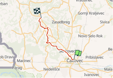
Trail On foot of 13.2 km to be discovered at Unknown, Međimurje County. This trail is proposed by SityTrail - itinéraires balisés pédestres.
Description
Trail created by PD Bundek Mursko Središće.
Website: http://bundek.hr/mpp/medimurski-planinarski-put/
Positioning
Country:
Croatia
Region :
Unknown
Department/Province :
Međimurje County
Municipality :
Unknown
Location:
Unknown
Start:(Dec)
Start:(UTM)
610287 ; 5138371 (33T) N.
Comments
Trails nearby
![Trail On foot - Svetomartinska Mura - Photo](https://media.geolcdn.com/t/375/260/787ffdb7-9087-44c2-8a34-a12d009e25c3.jpeg&format=jpg&maxdim=2)
![On foot On foot](https://static1.geolcdn.com/sitytour/trail-icons/100.png)
Svetomartinska Mura
On foot
Easy
,
Unknown,
Međimurje County,
Croatia
![](/images/other/stat-length.png)
3.7 km | 4.1 km-effort
55min
![](https://static1.geolcdn.com/siteimages/upload/files/16400158638029165_repeat_loop_refresh_sync_direction_icon.png)
No
![Trail On foot Tormafölde - P+ - Photo](https://media.geolcdn.com/t/375/260/ext.jpg?maxdim=2&url=https%3A%2F%2Fstatic1.geolcdn.com%2Fsiteimages%2Fupload%2Ffiles%2F1545311037marcheuse_200dpi.jpg)
![On foot On foot](https://static1.geolcdn.com/sitytour/trail-icons/100.png)