![](/images/other/stat-length.png)
![Trail On foot Domašov - Naučná stezka Rudka - Photo](https://media.geolcdn.com/t/1900/400/cd89e092-9e11-4b0e-847d-1385bffcb052.jpeg&format=pjpeg&maxdim=2)
Naučná stezka Rudka
SityTrail - itinéraires balisés pédestres
Tous les sentiers balisés d’Europe GUIDE+
![Length](/images/other/stat-length.png)
Length
4.2 km
![Max alt](https://static1.geolcdn.com/siteimages/upload/files/1508320355ic_sort_altitude_max_24dp.png)
Max alt
507 m
![Uphill gradient](https://static1.geolcdn.com/siteimages/upload/files/1508320355ic_sort_den_pos_24dp.png)
Uphill gradient
74 m
![Km-Effort](/images/other/stat-length.png)
Km-Effort
5.2 km
![Min alt](https://static1.geolcdn.com/siteimages/upload/files/1508320355ic_sort_altitude_min_24dp.png)
Min alt
440 m
![Downhill gradient](https://static1.geolcdn.com/siteimages/upload/files/1508320355ic_sort_den_neg_24dp.png)
Downhill gradient
97 m
![Boucle](https://static1.geolcdn.com/siteimages/upload/files/16400158638029165_repeat_loop_refresh_sync_direction_icon.png)
Boucle
No
Signpost
Creation date :
2025-02-07 17:19:03.825
Updated on :
2025-02-07 17:19:03.825
![On foot](https://static1.geolcdn.com/sitytour/trail-icons/100.png)
1h11
Difficulty : Easy
![Scan this QR Code to open this trail in the SityTrail application](https://capi.geolives.com/qq0zvz2zws4bq2lad0pu/sitytour/trails/4346349/qr.png?size=200)
FREE GPS app for hiking
About
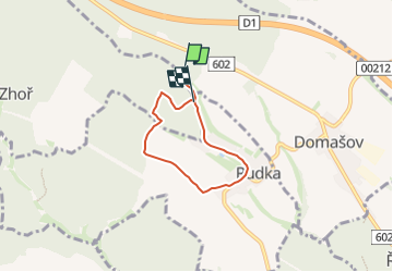
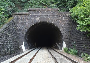
Trail On foot of 4.2 km to be discovered at Southeast, Jihomoravský kraj, Domašov. This trail is proposed by SityTrail - itinéraires balisés pédestres.
Description
Trail created by Obec Rudka.
Positioning
Country:
Czech Republic
Region :
Southeast
Department/Province :
Jihomoravský kraj
Municipality :
Domašov
Location:
Unknown
Start:(Dec)
Start:(UTM)
596124 ; 5456274 (33U) N.
Comments
Trails nearby
![Trail On foot Tišnov - Po starých názvech Jamného - Photo](https://media.geolcdn.com/t/375/260/179411d4-a256-427f-9746-de8ed0aa2d4f.jpeg&format=jpg&maxdim=2)
![On foot On foot](https://static1.geolcdn.com/sitytour/trail-icons/100.png)
Po starých názvech Jamného
On foot
Easy
Tišnov,
Southeast,
Jihomoravský kraj,
Czech Republic
![](/images/other/stat-length.png)
5.4 km | 7.5 km-effort
1h 42min
![](https://static1.geolcdn.com/siteimages/upload/files/16400158638029165_repeat_loop_refresh_sync_direction_icon.png)
Yes
![Trail On foot Čebín - Čebín - Zlobice - Photo](https://media.geolcdn.com/t/375/260/b60cb30c-597c-4eb3-be87-cebf3988ef78.jpeg&format=jpg&maxdim=2)
![On foot On foot](https://static1.geolcdn.com/sitytour/trail-icons/100.png)
Čebín - Zlobice
On foot
Easy
Čebín,
Southeast,
Jihomoravský kraj,
Czech Republic
![](/images/other/stat-length.png)
6.9 km | 10.3 km-effort
2h 20min
![](https://static1.geolcdn.com/siteimages/upload/files/16400158638029165_repeat_loop_refresh_sync_direction_icon.png)
No
![Trail On foot Brno - NS Jelení žlíbek - Photo](https://media.geolcdn.com/t/375/260/6b816b6a-5ba8-4ce8-8ed6-d16b66c07601.jpeg&format=jpg&maxdim=2)
![On foot On foot](https://static1.geolcdn.com/sitytour/trail-icons/100.png)
NS Jelení žlíbek
On foot
Easy
Brno,
Southeast,
Jihomoravský kraj,
Czech Republic
![](/images/other/stat-length.png)
3.3 km | 5.2 km-effort
1h 10min
![](https://static1.geolcdn.com/siteimages/upload/files/16400158638029165_repeat_loop_refresh_sync_direction_icon.png)
No
![Trail On foot Lomnice - naučná stezka Járy Cimrmana - Photo](https://media.geolcdn.com/t/375/260/10d7421d-cfd1-4327-8e81-fb06f3955da3.jpeg&format=jpg&maxdim=2)
![On foot On foot](https://static1.geolcdn.com/sitytour/trail-icons/100.png)
naučná stezka Járy Cimrmana
On foot
Easy
Lomnice,
Southeast,
Jihomoravský kraj,
Czech Republic
![](/images/other/stat-length.png)
4.9 km | 7.7 km-effort
1h 45min
![](https://static1.geolcdn.com/siteimages/upload/files/16400158638029165_repeat_loop_refresh_sync_direction_icon.png)
No
![Trail On foot Předklášteří - Naučná stezka Květnice - Photo](https://media.geolcdn.com/t/375/260/2c18e53a-ea8e-4eb9-9d60-e34adc5101e9.jpeg&format=jpg&maxdim=2)
![On foot On foot](https://static1.geolcdn.com/sitytour/trail-icons/100.png)
Naučná stezka Květnice
On foot
Easy
Předklášteří,
Southeast,
Jihomoravský kraj,
Czech Republic
![](/images/other/stat-length.png)
6.2 km | 9.2 km-effort
2h 5min
![](https://static1.geolcdn.com/siteimages/upload/files/16400158638029165_repeat_loop_refresh_sync_direction_icon.png)
Yes
![Trail On foot Mohelno - Naučná stezka národní přírodní rezervace Mohelenská hadcová step - Photo](https://media.geolcdn.com/t/375/260/83a4f499-7909-4101-ba16-31f711dd9df3.jpeg&format=jpg&maxdim=2)
![On foot On foot](https://static1.geolcdn.com/sitytour/trail-icons/100.png)
Naučná stezka národní přírodní rezervace Mohelenská hadcová step
On foot
Easy
Mohelno,
Southeast,
Kraj Vysočina,
Czech Republic
![](/images/other/stat-length.png)
3.2 km | 4.8 km-effort
1h 5min
![](https://static1.geolcdn.com/siteimages/upload/files/16400158638029165_repeat_loop_refresh_sync_direction_icon.png)
Yes
![Trail On foot Náměšť nad Oslavou - [Ž] Náměšť nad Oslavou - Bába - Photo](https://media.geolcdn.com/t/375/260/8da42828-a837-4296-8ed8-042629ea6d88.jpeg&format=jpg&maxdim=2)
![On foot On foot](https://static1.geolcdn.com/sitytour/trail-icons/100.png)
[Ž] Náměšť nad Oslavou - Bába
On foot
Easy
Náměšť nad Oslavou,
Southeast,
Kraj Vysočina,
Czech Republic
![](/images/other/stat-length.png)
3.3 km | 4.7 km-effort
1h 3min
![](https://static1.geolcdn.com/siteimages/upload/files/16400158638029165_repeat_loop_refresh_sync_direction_icon.png)
No
![Trail On foot Rozdrojovice - [M] Žebětín - Rozdrojovice - Photo](https://media.geolcdn.com/t/375/260/682a79b8-a1d7-45d4-a97b-8208da66a550.jpeg&format=jpg&maxdim=2)
![On foot On foot](https://static1.geolcdn.com/sitytour/trail-icons/100.png)
[M] Žebětín - Rozdrojovice
On foot
Medium
Rozdrojovice,
Southeast,
Jihomoravský kraj,
Czech Republic
![](/images/other/stat-length.png)
15.2 km | 21 km-effort
4h 48min
![](https://static1.geolcdn.com/siteimages/upload/files/16400158638029165_repeat_loop_refresh_sync_direction_icon.png)
No
![Trail On foot Předklášteří - Naučná stezka Předklášteří - Photo](https://media.geolcdn.com/t/375/260/cb9a6e18-c89b-4932-bdd7-cb7bf347623e.jpeg&format=jpg&maxdim=2)
![On foot On foot](https://static1.geolcdn.com/sitytour/trail-icons/100.png)
Naučná stezka Předklášteří
On foot
Easy
Předklášteří,
Southeast,
Jihomoravský kraj,
Czech Republic
![](/images/other/stat-length.png)
5 km | 8.3 km-effort
1h 53min
![](https://static1.geolcdn.com/siteimages/upload/files/16400158638029165_repeat_loop_refresh_sync_direction_icon.png)
No