![](/images/other/stat-length.png)
![Trail On foot Veliny - Naučná stezka rytíře Velingera - Photo](https://media.geolcdn.com/t/1900/400/b2a4504b-4d31-41bf-ab67-463221cb32b7.jpeg&format=pjpeg&maxdim=2)
Naučná stezka rytíře Velingera
SityTrail - itinéraires balisés pédestres
Tous les sentiers balisés d’Europe GUIDE+
![Length](/images/other/stat-length.png)
Length
4.5 km
![Max alt](https://static1.geolcdn.com/siteimages/upload/files/1508320355ic_sort_altitude_max_24dp.png)
Max alt
312 m
![Uphill gradient](https://static1.geolcdn.com/siteimages/upload/files/1508320355ic_sort_den_pos_24dp.png)
Uphill gradient
56 m
![Km-Effort](/images/other/stat-length.png)
Km-Effort
5.3 km
![Min alt](https://static1.geolcdn.com/siteimages/upload/files/1508320355ic_sort_altitude_min_24dp.png)
Min alt
275 m
![Downhill gradient](https://static1.geolcdn.com/siteimages/upload/files/1508320355ic_sort_den_neg_24dp.png)
Downhill gradient
62 m
![Boucle](https://static1.geolcdn.com/siteimages/upload/files/16400158638029165_repeat_loop_refresh_sync_direction_icon.png)
Boucle
No
Signpost
Creation date :
2025-02-07 17:12:29.939
Updated on :
2025-02-07 17:12:29.939
![On foot](https://static1.geolcdn.com/sitytour/trail-icons/100.png)
1h12
Difficulty : Easy
![Scan this QR Code to open this trail in the SityTrail application](https://capi.geolives.com/qq0zvz2zws4bq2lad0pu/sitytour/trails/4346325/qr.png?size=200)
FREE GPS app for hiking
About
Trail On foot of 4.5 km to be discovered at Northeast, Pardubický kraj, Veliny. This trail is proposed by SityTrail - itinéraires balisés pédestres.
Description
Trail created by obec Veliny.
Website: https://veliny.cz/turista/naucna-stezka-rytire-velingera/
Positioning
Country:
Czech Republic
Region :
Northeast
Department/Province :
Pardubický kraj
Municipality :
Veliny
Location:
Unknown
Start:(Dec)
Start:(UTM)
576448 ; 5548260 (33U) N.
Comments
Trails nearby
![Trail On foot Holice - CZ-4243 - Photo](https://media.geolcdn.com/t/375/260/44aaae75-ea87-4e90-8e7c-5cfea5f7e555.jpeg&format=jpg&maxdim=2)
![On foot On foot](https://static1.geolcdn.com/sitytour/trail-icons/100.png)
CZ-4243
On foot
Easy
Holice,
Northeast,
Pardubický kraj,
Czech Republic
![](/images/other/stat-length.png)
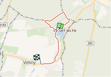
3.3 km | 4 km-effort
55min
![](https://static1.geolcdn.com/siteimages/upload/files/16400158638029165_repeat_loop_refresh_sync_direction_icon.png)
Yes
![Trail On foot Choceň - NS Dívčí doly - Photo](https://media.geolcdn.com/t/375/260/0bcec713-5f83-4b6a-aab0-8a056fd60769.jpeg&format=jpg&maxdim=2)
![On foot On foot](https://static1.geolcdn.com/sitytour/trail-icons/100.png)
NS Dívčí doly
On foot
Easy
Choceň,
Northeast,
Pardubický kraj,
Czech Republic
![](/images/other/stat-length.png)
3.9 km | 5 km-effort
1h 8min
![](https://static1.geolcdn.com/siteimages/upload/files/16400158638029165_repeat_loop_refresh_sync_direction_icon.png)
Yes
![Trail On foot Brandýs nad Orlicí - [Ž] Brandýs nad Orlicí - okruh - Photo](https://media.geolcdn.com/t/375/260/a13f2b27-51e8-4d6a-a5e1-59cd4671df46.jpeg&format=jpg&maxdim=2)
![On foot On foot](https://static1.geolcdn.com/sitytour/trail-icons/100.png)
[Ž] Brandýs nad Orlicí - okruh
On foot
Easy
Brandýs nad Orlicí,
Northeast,
Pardubický kraj,
Czech Republic
![](/images/other/stat-length.png)
3.2 km | 4.6 km-effort
1h 3min
![](https://static1.geolcdn.com/siteimages/upload/files/16400158638029165_repeat_loop_refresh_sync_direction_icon.png)
Yes
![Trail On foot Libel - NS Ovocná stezka - Photo](https://media.geolcdn.com/t/375/260/daee5e00-8280-4983-8fd9-520c10ca8ef1.jpeg&format=jpg&maxdim=2)
![On foot On foot](https://static1.geolcdn.com/sitytour/trail-icons/100.png)
NS Ovocná stezka
On foot
Easy
Libel,
Northeast,
Královéhradecký kraj,
Czech Republic
![](/images/other/stat-length.png)
5.6 km | 6.8 km-effort
1h 32min
![](https://static1.geolcdn.com/siteimages/upload/files/16400158638029165_repeat_loop_refresh_sync_direction_icon.png)
No
![Trail On foot Rychnov nad Kněžnou - PPP Stezka - Photo](https://media.geolcdn.com/t/375/260/3b8acea2-8e53-464b-9838-a97d5e19febe.jpeg&format=jpg&maxdim=2)
![On foot On foot](https://static1.geolcdn.com/sitytour/trail-icons/100.png)
PPP Stezka
On foot
Easy
Rychnov nad Kněžnou,
Northeast,
Královéhradecký kraj,
Czech Republic
![](/images/other/stat-length.png)
4.3 km | 5.4 km-effort
1h 13min
![](https://static1.geolcdn.com/siteimages/upload/files/16400158638029165_repeat_loop_refresh_sync_direction_icon.png)
No
![Trail On foot Vysoké Mýto - NS Knířov - Vánice - Photo](https://media.geolcdn.com/t/375/260/0cd8f36a-2cc8-45ab-8d9e-fb179da62e5a.jpeg&format=jpg&maxdim=2)
![On foot On foot](https://static1.geolcdn.com/sitytour/trail-icons/100.png)
NS Knířov - Vánice
On foot
Easy
Vysoké Mýto,
Northeast,
Pardubický kraj,
Czech Republic
![](/images/other/stat-length.png)
7.9 km | 9.2 km-effort
2h 5min
![](https://static1.geolcdn.com/siteimages/upload/files/16400158638029165_repeat_loop_refresh_sync_direction_icon.png)
Yes
![Trail On foot Týniště nad Orlicí - Poorlická NS - Photo](https://media.geolcdn.com/t/375/260/e040fbfa-7619-48b5-83bf-c6ad79a1d10b.jpeg&format=jpg&maxdim=2)
![On foot On foot](https://static1.geolcdn.com/sitytour/trail-icons/100.png)
Poorlická NS
On foot
Easy
Týniště nad Orlicí,
Northeast,
Královéhradecký kraj,
Czech Republic
![](/images/other/stat-length.png)
11.7 km | 13.1 km-effort
2h 58min
![](https://static1.geolcdn.com/siteimages/upload/files/16400158638029165_repeat_loop_refresh_sync_direction_icon.png)
Yes
![Trail On foot Vysoká nad Labem - NS Koliba - Photo](https://media.geolcdn.com/t/375/260/82fea0da-f465-4ff8-8315-666d12e384fb.jpeg&format=jpg&maxdim=2)
![On foot On foot](https://static1.geolcdn.com/sitytour/trail-icons/100.png)
NS Koliba
On foot
Easy
Vysoká nad Labem,
Northeast,
Královéhradecký kraj,
Czech Republic
![](/images/other/stat-length.png)
7 km | 8.2 km-effort
1h 51min
![](https://static1.geolcdn.com/siteimages/upload/files/16400158638029165_repeat_loop_refresh_sync_direction_icon.png)
No
![Trail On foot Polom - [M] Polom - Pod hradem Velešov - Photo](https://media.geolcdn.com/t/375/260/0391b491-45a7-4827-b429-651f702f935c.jpeg&format=jpg&maxdim=2)
![On foot On foot](https://static1.geolcdn.com/sitytour/trail-icons/100.png)
[M] Polom - Pod hradem Velešov
On foot
Easy
Polom,
Northeast,
Královéhradecký kraj,
Czech Republic
![](/images/other/stat-length.png)
8.8 km | 11.5 km-effort
2h 36min
![](https://static1.geolcdn.com/siteimages/upload/files/16400158638029165_repeat_loop_refresh_sync_direction_icon.png)
No