


3.6 km | 4.6 km-effort
![Trail On foot Nosislav - [M] Nosislav - Výhon - Photo](https://media.geolcdn.com/t/1900/400/f5229b3c-0400-439f-9460-019b796ae514.jpeg&format=pjpeg&maxdim=2)

Tous les sentiers balisés d’Europe GUIDE+


FREE GPS app for hiking
 SityTrail
IGN / Geographical institutes
SityTrail World
The world is yours!
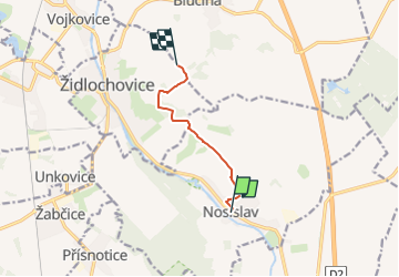
Trail On foot of 5.3 km to be discovered at Southeast, Jihomoravský kraj, Nosislav. This trail is proposed by SityTrail - itinéraires balisés pédestres.
Trail created by cz:KČT.
![Trail On foot Nosislav - [M] Nosislav - Výhon - Photo 1](https://media.geolcdn.com/t/2048/auto/134fa8b0-7e52-45cd-b5aa-a521fd95f978.jpeg&format=jpg&maxdim=0 "Trail On foot Nosislav - [M] Nosislav - Výhon - Photo 1")
![Trail On foot Nosislav - [M] Nosislav - Výhon - Photo 2](https://media.geolcdn.com/t/2048/auto/60ddfb0b-7a90-4abc-9113-005015e18de4.jpeg&format=jpg&maxdim=0 "Trail On foot Nosislav - [M] Nosislav - Výhon - Photo 2")
![Trail On foot Nosislav - [M] Nosislav - Výhon - Photo 3](https://media.geolcdn.com/t/2048/auto/fcd55d25-c3a9-4b5c-8ef8-39a91b93cfb7.jpeg&format=jpg&maxdim=0 "Trail On foot Nosislav - [M] Nosislav - Výhon - Photo 3")
![Trail On foot Nosislav - [M] Nosislav - Výhon - Photo 4](https://media.geolcdn.com/t/2048/auto/804ab926-6dc9-41ee-891c-ac1b77e34536.jpeg&format=jpg&maxdim=0 "Trail On foot Nosislav - [M] Nosislav - Výhon - Photo 4")
![Trail On foot Nosislav - [M] Nosislav - Výhon - Photo 5](https://media.geolcdn.com/t/2048/auto/81fd1a51-929b-4a75-9e7d-6b5031b827dd.jpeg&format=jpg&maxdim=0 "Trail On foot Nosislav - [M] Nosislav - Výhon - Photo 5")
![Trail On foot Nosislav - [M] Nosislav - Výhon - Photo 6](https://media.geolcdn.com/t/2048/auto/a6b0e99d-2438-4852-94cd-45875339b62d.jpeg&format=jpg&maxdim=0 "Trail On foot Nosislav - [M] Nosislav - Výhon - Photo 6")
![Trail On foot Nosislav - [M] Nosislav - Výhon - Photo 7](https://media.geolcdn.com/t/2048/auto/43f507ff-8e68-492b-ae64-519b1345c138.jpeg&format=jpg&maxdim=0 "Trail On foot Nosislav - [M] Nosislav - Výhon - Photo 7")
![Trail On foot Nosislav - [M] Nosislav - Výhon - Photo 8](https://media.geolcdn.com/t/2048/auto/3f3911a3-f2a6-430f-87f2-0b332e295444.jpeg&format=jpg&maxdim=0 "Trail On foot Nosislav - [M] Nosislav - Výhon - Photo 8")
![Trail On foot Nosislav - [M] Nosislav - Výhon - Photo 9](https://media.geolcdn.com/t/2048/auto/4b9147ce-72f0-4076-a261-ea8b6641ff21.jpeg&format=jpg&maxdim=0 "Trail On foot Nosislav - [M] Nosislav - Výhon - Photo 9")
![Trail On foot Nosislav - [M] Nosislav - Výhon - Photo 10](https://media.geolcdn.com/t/2048/auto/f5229b3c-0400-439f-9460-019b796ae514.jpeg&format=jpg&maxdim=0 "Trail On foot Nosislav - [M] Nosislav - Výhon - Photo 10")
![Trail On foot Židlochovice - [Ž] Židlochovice - Skalky - Photo](https://media.geolcdn.com/t/375/260/db85c2d5-5da1-443d-b198-8a8206c0e6ff.jpeg&format=jpg&maxdim=2)
On foot
![Trail On foot Blučina - [Z] Hrušovany u Brna - Blučina - Photo](https://media.geolcdn.com/t/375/260/0f208fae-959c-4546-8942-d838c94e7471.jpeg&format=jpg&maxdim=2)
On foot