


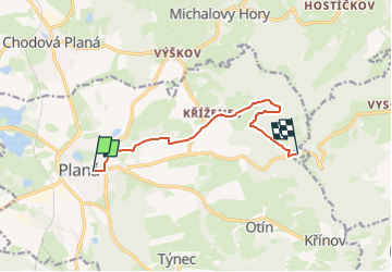

7 km | 8.4 km-effort
![Trail On foot Planá - [Ž] Planá - Caltov - Photo](https://media.geolcdn.com/t/1900/400/d3274dee-8d07-4931-ac79-1d03303a6581.jpeg&format=pjpeg&maxdim=2)

Tous les sentiers balisés d’Europe GUIDE+


FREE GPS app for hiking
 SityTrail
IGN / Geographical institutes
SityTrail World
The world is yours!
Trail On foot of 7.7 km to be discovered at Southwest, Plzeňský kraj, Planá. This trail is proposed by SityTrail - itinéraires balisés pédestres.
Trail created by cz:KČT.
![Trail On foot Planá - [Ž] Planá - Caltov - Photo 1](https://media.geolcdn.com/t/2048/auto/0f2d247c-e853-4dc2-b72d-ce3c0d9b1130.jpeg&format=jpg&maxdim=0 "Trail On foot Planá - [Ž] Planá - Caltov - Photo 1")
![Trail On foot Planá - [Ž] Planá - Caltov - Photo 2](https://media.geolcdn.com/t/2048/auto/e36c21c3-2265-4536-b639-0f84044d5d16.jpeg&format=jpg&maxdim=0 "Trail On foot Planá - [Ž] Planá - Caltov - Photo 2")
![Trail On foot Planá - [Ž] Planá - Caltov - Photo 3](https://media.geolcdn.com/t/2048/auto/3af649c6-1223-4c53-ac0b-731c5836e775.jpeg&format=jpg&maxdim=0 "Trail On foot Planá - [Ž] Planá - Caltov - Photo 3")
![Trail On foot Planá - [Ž] Planá - Caltov - Photo 4](https://media.geolcdn.com/t/2048/auto/32185d89-9f5a-4ddb-841f-109978af5a23.jpeg&format=jpg&maxdim=0 "Trail On foot Planá - [Ž] Planá - Caltov - Photo 4")
![Trail On foot Planá - [Ž] Planá - Caltov - Photo 5](https://media.geolcdn.com/t/2048/auto/e6071fb7-1268-430b-a18e-3ace304274f8.jpeg&format=jpg&maxdim=0 "Trail On foot Planá - [Ž] Planá - Caltov - Photo 5")
![Trail On foot Planá - [Ž] Planá - Caltov - Photo 6](https://media.geolcdn.com/t/2048/auto/0ba8c225-5359-457e-b991-5b5f4708e2af.jpeg&format=jpg&maxdim=0 "Trail On foot Planá - [Ž] Planá - Caltov - Photo 6")
![Trail On foot Planá - [Ž] Planá - Caltov - Photo 7](https://media.geolcdn.com/t/2048/auto/b982f266-e78e-4999-a32b-a17f11eac743.jpeg&format=jpg&maxdim=0 "Trail On foot Planá - [Ž] Planá - Caltov - Photo 7")
![Trail On foot Planá - [Ž] Planá - Caltov - Photo 8](https://media.geolcdn.com/t/2048/auto/231d3a57-66e6-400f-8f30-80200171ae84.jpeg&format=jpg&maxdim=0 "Trail On foot Planá - [Ž] Planá - Caltov - Photo 8")
![Trail On foot Planá - [Ž] Planá - Caltov - Photo 9](https://media.geolcdn.com/t/2048/auto/937c7cf5-50a8-4c8b-82c6-892663ce88a0.jpeg&format=jpg&maxdim=0 "Trail On foot Planá - [Ž] Planá - Caltov - Photo 9")
![Trail On foot Planá - [Ž] Planá - Caltov - Photo 10](https://media.geolcdn.com/t/2048/auto/d3274dee-8d07-4931-ac79-1d03303a6581.jpeg&format=jpg&maxdim=0 "Trail On foot Planá - [Ž] Planá - Caltov - Photo 10")
On foot