


7.1 km | 9.7 km-effort
![Trail On foot Konice - [Z] Runářov - Konice - Photo](https://media.geolcdn.com/t/1900/400/90af7c62-097b-4fe0-b74f-f80499e5b5f8.jpeg&format=pjpeg&maxdim=2)

Tous les sentiers balisés d’Europe GUIDE+


FREE GPS app for hiking
 SityTrail
IGN / Geographical institutes
SityTrail World
The world is yours!
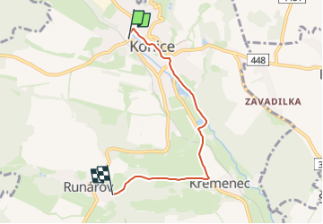
Trail On foot of 4.3 km to be discovered at Central Moravia, Olomouc Region, Konice. This trail is proposed by SityTrail - itinéraires balisés pédestres.
Trail created by cz:KČT.
![Trail On foot Konice - [Z] Runářov - Konice - Photo 1](https://media.geolcdn.com/t/2048/auto/44cbd376-a5a9-467e-9bd9-7f131eae108d.jpeg&format=jpg&maxdim=0 "Trail On foot Konice - [Z] Runářov - Konice - Photo 1")
![Trail On foot Konice - [Z] Runářov - Konice - Photo 2](https://media.geolcdn.com/t/2048/auto/59c9deb1-188d-4c30-92c5-70bf8c324931.jpeg&format=jpg&maxdim=0 "Trail On foot Konice - [Z] Runářov - Konice - Photo 2")
![Trail On foot Konice - [Z] Runářov - Konice - Photo 3](https://media.geolcdn.com/t/2048/auto/569dd492-61fb-46bb-b856-f0f8a714892c.jpeg&format=jpg&maxdim=0 "Trail On foot Konice - [Z] Runářov - Konice - Photo 3")
![Trail On foot Konice - [Z] Runářov - Konice - Photo 4](https://media.geolcdn.com/t/2048/auto/aa2a174d-686c-430c-b9ca-28ce3748589f.jpeg&format=jpg&maxdim=0 "Trail On foot Konice - [Z] Runářov - Konice - Photo 4")
![Trail On foot Konice - [Z] Runářov - Konice - Photo 5](https://media.geolcdn.com/t/2048/auto/a5117e28-1c29-489c-b9c9-8e8adb54ec72.jpeg&format=jpg&maxdim=0 "Trail On foot Konice - [Z] Runářov - Konice - Photo 5")
![Trail On foot Konice - [Z] Runářov - Konice - Photo 6](https://media.geolcdn.com/t/2048/auto/00835467-f406-4b7a-84e3-d64a2d68adbf.jpeg&format=jpg&maxdim=0 "Trail On foot Konice - [Z] Runářov - Konice - Photo 6")
![Trail On foot Konice - [Z] Runářov - Konice - Photo 7](https://media.geolcdn.com/t/2048/auto/b761a79b-15fa-41ae-9287-b17143fcdd4c.jpeg&format=jpg&maxdim=0 "Trail On foot Konice - [Z] Runářov - Konice - Photo 7")
![Trail On foot Konice - [Z] Runářov - Konice - Photo 8](https://media.geolcdn.com/t/2048/auto/9ddb23b6-c820-41c9-9412-705130694c90.jpeg&format=jpg&maxdim=0 "Trail On foot Konice - [Z] Runářov - Konice - Photo 8")
![Trail On foot Konice - [Z] Runářov - Konice - Photo 9](https://media.geolcdn.com/t/2048/auto/7a84e6c3-a6dd-4191-9523-05f82fd69755.jpeg&format=jpg&maxdim=0 "Trail On foot Konice - [Z] Runářov - Konice - Photo 9")
![Trail On foot Konice - [Z] Runářov - Konice - Photo 10](https://media.geolcdn.com/t/2048/auto/90af7c62-097b-4fe0-b74f-f80499e5b5f8.jpeg&format=jpg&maxdim=0 "Trail On foot Konice - [Z] Runářov - Konice - Photo 10")
On foot