


利尻山鴛泊コース

SityTrail - itinéraires balisés pédestres
Tous les sentiers balisés d’Europe GUIDE+
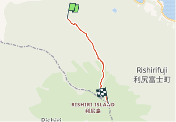

Length
6.2 km

Max alt
1687 m

Uphill gradient
1479 m
Km-Effort
21 km

Min alt
213 m

Downhill gradient
12 m
Boucle
No

Signpost
Creation date :
2025-02-07 16:19:57.223
Updated on :
2025-02-07 16:19:57.223
4h47
Difficulty : Medium

FREE GPS app for hiking
 SityTrail
IGN / Geographical institutes
SityTrail World
The world is yours!
About
Trail On foot of 6.2 km to be discovered at Hokkaido Prefecture, Rishiri County, Unknown. This trail is proposed by SityTrail - itinéraires balisés pédestres.
Photos


Positioning
Country:
Japan
Region :
Hokkaido Prefecture
Department/Province :
Rishiri County
Municipality :
Unknown
Location:
鴛泊
Start:(Dec)
Start:(UTM)
516685 ; 5007720 (54T) N.
Comments
Trails nearby