![](/images/other/stat-length.png)
![Trail On foot Unknown - Path across the peak of Dinara - Photo](https://media.geolcdn.com/t/1900/400/d761895b-49a7-4b3b-8818-06c288ba4289.jpeg&format=pjpeg&maxdim=2)
Path across the peak of Dinara
SityTrail - itinéraires balisés pédestres
Tous les sentiers balisés d’Europe GUIDE+
![Length](/images/other/stat-length.png)
![Max alt](https://static1.geolcdn.com/siteimages/upload/files/1508320355ic_sort_altitude_max_24dp.png)
![Uphill gradient](https://static1.geolcdn.com/siteimages/upload/files/1508320355ic_sort_den_pos_24dp.png)
![Km-Effort](/images/other/stat-length.png)
![Min alt](https://static1.geolcdn.com/siteimages/upload/files/1508320355ic_sort_altitude_min_24dp.png)
![Downhill gradient](https://static1.geolcdn.com/siteimages/upload/files/1508320355ic_sort_den_neg_24dp.png)
![Boucle](https://static1.geolcdn.com/siteimages/upload/files/16400158638029165_repeat_loop_refresh_sync_direction_icon.png)
![On foot](https://static1.geolcdn.com/sitytour/trail-icons/100.png)
6h52
Difficulty : Medium
![Scan this QR Code to open this trail in the SityTrail application](https://capi.geolives.com/qq0zvz2zws4bq2lad0pu/sitytour/trails/4346152/qr.png?size=200)
FREE GPS app for hiking
About
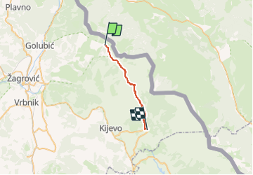
Trail On foot of 17.9 km to be discovered at Unknown, Šibenik-Knin County. This trail is proposed by SityTrail - itinéraires balisés pédestres.
Description
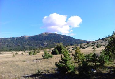
Behind the Brezovac mountain hut, the marked trail continues to the peak of Dinara – the highest peak of Croatia. In 20 minutes, we reach the edge of the meadow called Duler, continuing from that meadow to the wide meadow of Samar. A wide path ascends along Samar for a considerable amount of ...
Website: https://trail.viadinarica.com/tour/hiking/16008868/
Positioning
Comments
Trails nearby
![Trail On foot - yogurt staza Mirkovići-Dinara - Photo](https://media.geolcdn.com/t/375/260/29a1aecf-36fc-498e-8743-c859be60c896.jpeg&format=jpg&maxdim=2)
![On foot On foot](https://static1.geolcdn.com/sitytour/trail-icons/100.png)
On foot
![](/images/other/stat-length.png)
![](https://static1.geolcdn.com/siteimages/upload/files/16400158638029165_repeat_loop_refresh_sync_direction_icon.png)
![Trail On foot - Glavaš-Dinara_brezovac - Photo](https://media.geolcdn.com/t/375/260/70028265-24e3-4592-9650-7b9a1d72b553.jpeg&format=jpg&maxdim=2)
![On foot On foot](https://static1.geolcdn.com/sitytour/trail-icons/100.png)
On foot
![](/images/other/stat-length.png)
![](https://static1.geolcdn.com/siteimages/upload/files/16400158638029165_repeat_loop_refresh_sync_direction_icon.png)
![Trail On foot - Guge-Brezovac - Photo](https://media.geolcdn.com/t/375/260/093a6e50-0cba-4ea6-8f57-cdfc99edf942.jpeg&format=jpg&maxdim=2)
![On foot On foot](https://static1.geolcdn.com/sitytour/trail-icons/100.png)
On foot
![](/images/other/stat-length.png)
![](https://static1.geolcdn.com/siteimages/upload/files/16400158638029165_repeat_loop_refresh_sync_direction_icon.png)
![Trail On foot - Glavaš-Dinara - Photo](https://media.geolcdn.com/t/375/260/b5ccdf9b-e704-4365-8026-b13b6609237c.jpeg&format=jpg&maxdim=2)
![On foot On foot](https://static1.geolcdn.com/sitytour/trail-icons/100.png)
On foot
![](/images/other/stat-length.png)
![](https://static1.geolcdn.com/siteimages/upload/files/16400158638029165_repeat_loop_refresh_sync_direction_icon.png)
![Trail On foot - Martinove košare-Leurdovac-Dinara - Photo](https://media.geolcdn.com/t/375/260/b5ccdf9b-e704-4365-8026-b13b6609237c.jpeg&format=jpg&maxdim=2)
![On foot On foot](https://static1.geolcdn.com/sitytour/trail-icons/100.png)
On foot
![](/images/other/stat-length.png)
![](https://static1.geolcdn.com/siteimages/upload/files/16400158638029165_repeat_loop_refresh_sync_direction_icon.png)